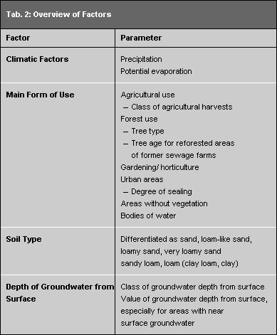
The Map of Total Runoff is the edition updated for Berlin from Map 2.03 (Runoff formation from precipitation and mean annual precipitation) from the "Ecological Resource Planning for Berlin and surrounding countryside" of 1991/92. The map scale was enlarged from 1:200,000 (grid area: 2.5 × 2.5 km) to 1:125,000 (grid area 1 × 1 km). Area information and calculations refer to it. Surface waters and lowland areas with near-surface groundwater were proportionately registered for the grid area and runoff calculations correspondingly taken into consideration. The runoff calculations refer to the precipitation values mentioned above, 1961 – 1990.
Data entered for:
Total Berlin
- long-term distribution of precipitation 1961 – 1990 (cf. Maps 04.08.1 – 3, SenStadtUm 1994a);
- values of potential evaporation, taken from a Map 1:1,000,000 (reduced overview in: Dyck et al. 1978, Image 3.26). It was prepared following Budyko, from climate station data of the GDR regarding the radiation balance of an area with continually high moisture.
- Evaporation from bodies of water from a Map of Evaporation Areas (650, 700, 750 and 800 mm/a) (cf. Richter 1979);
- areas of forest use (excepting reforested areas of former sewage farms) were assigned an average age. Tree type and age were not specially considered.
East Berlin
- Information for land use from the Topographical Maps (National Economy Edition) at a scale of 1:25,000 (status 1975/81) and 1:10,000 (status 1980/85) with specifications regarding
- classifications of agricultural yields from statements in Agricultural Cooperatives _Schlagkartei_ (area cadastre)and from estimates;
- tree type and age for reforested areas at former sewage farms in northern Berlin;
- degree of sealing from procentual estimates of built-up (sealed) areas within the grid area, such as buildings, streets, squares, courtyard areas, etc., by means of a grid pattern with an estimated deviation of about ±5 to ±10 % from actual value. The non-sealed area was classified according to the dominance principle into one of the main use categories; agricultural, forest exploited areas, gardening use, bodies of water.
- Statements about soil type were from Soil Estimate Maps at a scale of 1:10,000 or 1:25,000 (status 1934/51) and from soilgeological maps;
- Statements about groundwater depth from the surface from the difference of statements giving geodetic altitudes (Topographical Map 1:10,000 or 1:25,000) and the groundwater level of the upper groundwater storey (Hydrogeologic Map at a scale of 1:50,000, Map 2.2).
West Berlin
Information for land use:
- agricultural or forest exploited areas, garden areas or bodies of water categorized according to the dominance principle, from the Environmental Atlas – Map 06.02 Inventory of Green and Open Spaces (SenStadtUm 1987) and the Satellite Map of Berlin (SenBauWohn 1989);
- degree of sealing of built-up areas as in the Environmental Atlas – Map 01.02 Sealing of Soil Surfaces (SenStadtUm 1993, work status 1988);
- statements about soil type according to the Environmental Atlas – Map 01.01 Soil Societies (SenStadtUm 1985a);
- statements about groundwater depth from the surface from the Environmental Atlas – Map 02.07 Depth of Groundwater (SenStadtUm 1985b).