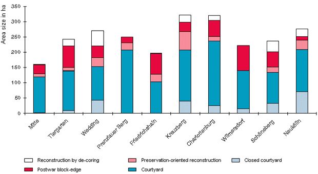
In Prenzlauer Berg, Kreuzberg, Charlottenburg and Neukölln, very much late 19th-century development of the area types “closed courtyard” and “courtyard” – over 200 ha in area – is still preserved in its original form. The share of very dense development of the type “closed courtyard” is relatively high in Neukölln, Wedding and Kreuzberg. Late 19th-century preservation-oriented reconstruction, under which the original block structures were largely preserved, occurred most prominently in the borough of Kreuzberg. In the districts of Tiergarten, Friedrichshain and Wilmersdorf, war-damaged late 19th-century block development was largely eliminated and replaced, particularly by new buildings of the “postwar block-edge” type. “Late 19th-century development with major changes” and “reconstruction by de-coring” became increasingly common in the district of
Wedding.
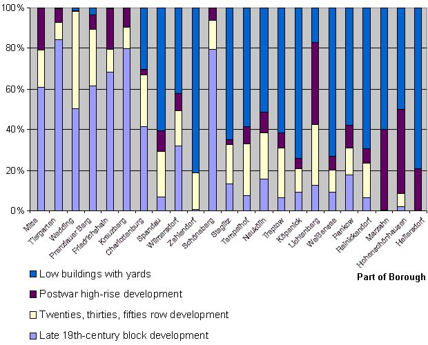
The twenties and thirties block-edge and row development type is found mainly outside the City Rail Circle Line. Frequently, the rows and large courts were erected in neighborhoods dominated by the “late 19th-century block-edge development with few wings and rear buildings” type, at the edge of the former suburbs of Berlin. They are as a rule connected to the City Rail and subway network.
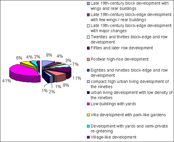
The fifties and later row developments were erected mostly in the Berlin outskirts, outside the City Rail Circle Line. They were laid out on former open spaces (agriculture areas, etc.) without regard to existing transportation corridors or construction structures. Within the Circle Line, formerly built-up areas were replaced by row development. This includes large areas in Kreuzberg, Mitte and Friedrichshain, but isolated areas with row development on top of former late 19th-century block structure also exist in other inner-city districts.
One finds postwar high-rise development of the “unplanned reconstruction” type in the western parts within the City Rail Circle Line. Large areas of this type exist in Wilmersdorf around Bundesallee, in the ditrict of Schöneberg in the area of Nollendorfplatz and Kleiststrasse, and in Kreuzberg between Wilhelmstrasse and Stresemannstrasse. Otherwise the high-rise development of the postwar era occurred within the City Rail Circle Line only in Kreuzberg, Mitte and Friedrichshain. Here smaller developments of the area type “high-rise” emerged. As a rule, the high-rise developments were erected outside the City Rail Circle Line. Such large complexes erected in West Berlin include Gropiusstadt in Neukölln, developments in Lichtenrade, Marienfelde, Lichterfelde and Spandau as well as the Märkische Viertel in Reinickendorf. In East Berlin the largest developments are found in Hohenschönhausen, Marzahn, Hellersdorf and Lichtenberg.
The eighties and nineties block-edge and row development of the pre-fab concrete construction type occurs mainly in Hellersdorf and Marzahn. Smaller settlements were built in Köpenick and Hohenschönhausen.
The approximately 250 areas of the type compact, high urban living development of the nineties, realized usually in the framework of town-planning development projects, are located mainly at the edge of the eastern part of the city, as in Karow north and Buchholz. Some of the big housing projects like e.g. the Rummelsburger Bucht are situated also in the city center. The biggest project in the west part of the city is the water city Spandau.
The structure type urban living development with low density of the nineties with approximately 75 separate areas, also was erected normally in the east part and at the outskirts in Pankow or Treptow-Köpenick. However, you can find this type isolated also in Steglitz-Zehlendorf and Spandau.
Construction structures with yards are as a rule found only on the outskirts of town. These low, single-family and duplex houses with yards are to be found in the entire outskirts area.
The villa development with park-like gardens emerged mainly during the late 19th-century in scenically attractive areas; this has hardly changed since then. One finds larger areas of this type near the Grunewald Forest in Nikolassee, Zehlendorf, Dahlem and Grunewald, in Lichterfelde, near the Tegel Forest in Hermsdorf and Frohnau, along the Dahme at Grünau, and in the area the Müggelspree at Rahnsdorf.
Development with yards and semi-private re-greening, in which villa development and/or low single family houses are interspersed with larger rental and studio-apartment houses, occurs mainly in the southern urban area, particularly in the transitional areas between villas and single family housing in West Lichterfelde and Zehlendorf.
Village-like development is still preserved on the outskirts of town only in the old village cores; in the eastern boroughs more and larger village structures can generally be found.
One finds the development with predominantly commercial and service use frequently in the old central business districts of the various parts of town. This applies particularly to both the city center areas of West and East Berlin concentrated around the Kurfürstendamm/ Tauentzienstrasse and/or around the Alexanderplatz/ Friedrichstrasse.
Structure types with predominantly small business and industrial use are concentrated along waterways and railroad lines. Heavily built-up small business areas occur less frequently than small business areas with low development.
Development with predominantly public facilities and special use is to be found relatively evenly distributed throughout the urban area. Obviously, green and open spaces are more available in the outskirts area than in the inner city. As traffic areas, the airports Tempelhof and Tegel, and the right-of-ways of the City Rail lines stand out.
Detailed information about structure types which do not serve predominantly the residential use are found in the Umweltatlas Maps 06.01 “Actual Use of Built-up Areas” and 06.02 “Inventory of Green and Open Spaces”.