Heavy Rainfall and Flood Hazards 2024

Map Description

Map 02.24.1 Heavy Rainfall Information Map

The heavy rainfall information map illustrates the results of the BWB’s topographic depression analysis and the operations of the Berlin Fire Brigade across the State of Berlin. It shows the extent of the depressions and classifies the number of fire service operations per block segment area. The map also shows for which flood hazard maps and for which flood risk areas there are heavy rainfall hazard maps based on the detailed coupled 1D sewer network/2D surface runoff simulation (1D/2D simulation):

  • block segment areas with one fire service operation (yellow),
  • block segment areas with two to five operations (orange),
  • with more than five fire service operations (red)
  • as well as no or an unknown number of fire service operations (grey).

These fire service operations linked to heavy rainfall act as an indicator for the likelihood of a reoccurrence and, therefore, an elevated risk of flood damage due to heavy rain. The individual fire service operations are displayed as dots when the map is zoomed in to a scale of 1:25,000 or more. Figure 1 provides a visual of the annual number of heavy-rainfall-related fire service operations. The year 2017 is particularly striking, with its heavy rainfall event from June 29 to June 30, 2017, and 1,004 recorded operations. On these two days, Berlin experienced unusually long and intense rainfall, which was mainly concentrated in the northwest of the city. Several regions experienced daily rainfall volumes equivalent to those of a 100-year event. Notably, Berlin-Tegel measured a daily rainfall total of 195.8 mm.

Fig. 1: Number of fire service operations due to heavy rainfall by year for the period from May 2005 to September 2021

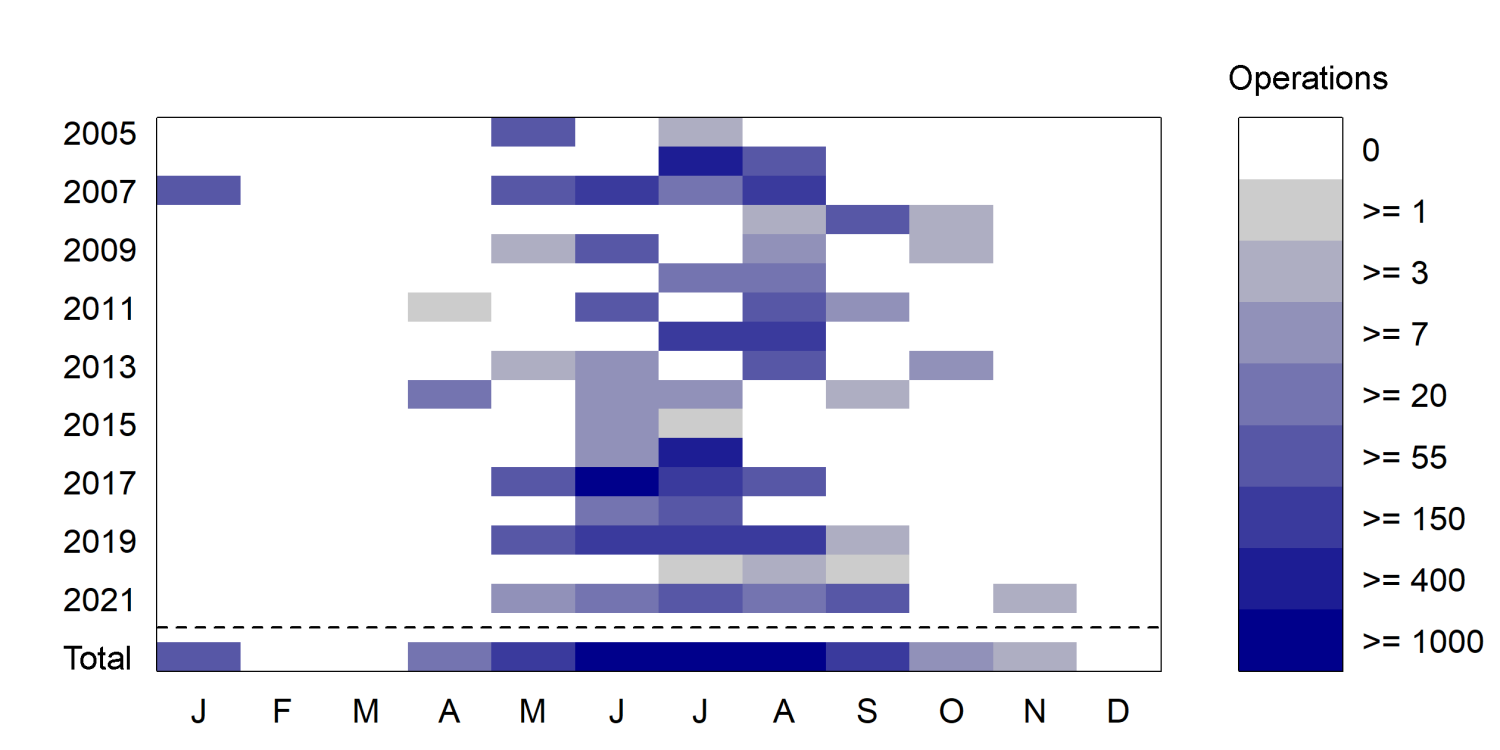
Figure 2 illustrates the distribution of fire service operations both by month and by year. Heavy rain-related fire service operations occur most frequently in the months between May and September, with concentrations peaking between June and August.

Fig. 2: Number of operations (colour coding) by year (rows) and month (columns) for all operations between 2005 and 2021

The depressions (turquoise) represent low points in the terrain where water might accumulate, potentially leading to the flooding of roads, squares, green spaces, and buildings. This is a purely topographic analysis that is not based on any specific precipitation scenarios. The depressions are therefore depicted independently of rainfall events and with their maximum potential volume. Drainage through sewerage systems (sewers, etc.) or factors such as infiltration into the ground were not taken into account in the analysis. Uncertainty in the depression data mainly arises from obstacles that impede the flow, such as bridges, railway and road embankments, or large culverts. Although they are crucial in determining the actual extent of a depression, they were not always considered. Additionally, small-scale structures such as curbs etc., cannot be factored in due to limitations in precision and resolution of the terrain model used.

Additionally, the map highlights areas for which detailed heavy rainfall hazard maps based on a coupled 1D/2D simulation are available. The flood hazard map not only illustrates the spatial extent of flooding from a river flood but also provides information on water depth for low-probability flood scenarios. A comprehensive description of the flood hazard and flood risk maps may be found in the Environmental Atlas. For Berlin, maps were developed only for risk areas and only for floods caused by river flooding. Floods caused by sewarage systems exceeding their capacity or groundwater surfacing, failure of dams installed for water-management purposes, or heavy rainfall are not shown on the maps.

The heavy rainfall information map therefore indicates areas potentially at risk of flooding and shows previously recorded heavy rainfall events. The map presented here combines a simple risk assessment, based on a topographic depression analysis, and data on fire service operations. It therefore offers a preliminary indication of areas prone to heavy rainfall-induced flooding, identifying topographic low points (depressions) and areas with a history of damage from such events. This facilitates an initial assessment and classification of areas at risk from heavy rainfall for existing buildings, infrastructures, and new buildings. Urban and land-use planning, for example, may then incorporate heavy rainfall preventive measures based on the heavy rainfall information map. With the map, areas that are potentially at risk may be identified and awareness for those involved may be raised early on. Please note, the heavy rainfall information map does not exempt individual projects from the responsibility to investigate and verify the hydraulic conditions on site. It is required to compare the model with the actual on-site conditions. All information is provided without a guarantee of accuracy. No liability will be assumed for damages resulting from the use of the retrieved information.

Map 02.24.1 Heavy Rainfall Hazard Map

The heavy rainfall hazard map illustrates the spatial extent of floods, flood depths (water level above ground), and flow velocities, providing insights into heavy rainfall-induced floods for different scenarios, including rare, extraordinary, and extreme events.

The heavy rainfall hazard map provides a detailed assessment of the spatial extent of floods, flood depths, and flow velocities for a variety of heavy rainfall scenarios. They play a crucial role in wastewater planning and are the cornerstone of the municipal heavy rainfall risk management. For the State of Berlin, these maps are particularly important for managing the heavy rainfall risks associated with rare (T = 30a, T = 50a according to KOSTRA-DWD as Euler Type II with a duration of 180 minutes), extraordinary (T = 100a according to KOSTRA-DWD as Euler Type II with a duration of 180 minutes), and extreme events (TExtrem = 100mm in 60 minutes as block rainfall).

The water level, or rather the water level above ground or inundation depth, is categorised into four classes. The highest observed water level is shown for each scenario. Levels below 0.1 m are not displayed, as the accuracy of the method and the underlying data does not allow for reliable assessments at these depths. Damage may still occur at these water levels, however. There is also an increased risk of accidents (e.g. due to aquaplaning). With inundation depths of 0.1 m or more, the risk of water penetrating into buildings or lower-lying parts of structures, such as basement flats, garage entrances, or underpasses, especially through ground-level features such as windows or light shafts, is considerably greater. Apart from the immediate risk of drowning, particularly for infants and children, there is also the risk of electric shock. Moreover, at a water level of 0.1 to 0.3 m, traffic is restricted, and as inundation depths rise (0.3–0.5 m), these risks amplify. Water is able to penetrate into buildings with slightly higher basement windows or raised entrances. Escape routes may be blocked due to the static pressure of the water. Furthermore, there is a risk of damage to parked vehicles, and roads become impassable for standard vehicles. Higher flood depths (> 0.5 m) significantly increase the risk of drowning for both children and adults. The static load on building and structural components increases, potentially posing an additional threat to human health in the event of collapse. At this point, only specialised vehicles are able to navigate the roads.

The flow velocity and direction (colour-coded flow arrows), which are based on the depth-averaged maximum velocity, are displayed when the map is zoomed in to a scale of 1:25,000 or more. From this, the flow paths as well as the origin and catchment area of local floods may be derived. Even minor flow velocities of up to 0.5 m/s may pose a risk to older individuals, those with limited mobility, infants, and children, when traversing a flow path, especially at greater depths. Seals may break due to increased pressure. With accelerating flow velocities (0.5–1.0 m/s), the risk increases during the crossing of a runoff path, which then also applies to adults. Due to the combination of static and dynamic forces the risk of failure of building and structural components increases. Higher flow velocities (> 1.0 m/s) may result in larger solid objects being carried by the flow (e.g., cars, tree trunks). These objects not only pose a direct threat to human safety but may also cause additional damage to building and structural components, amplifying the risk of failure. The water may be contaminated by foreign substances such as oil, faecal matter, or chemicals, leading to greater damage. For instance, damaged oil tanks not only jeopardise the building they are in, but also affect neighbouring structures as well as the environment. The structural integrity may also be compromised by undermining, potentially leading to the collapse of building and structural components. Time plays a key role in heavy rainfall events. The longer water persists, the greater the risk of further structural damage.

The heavy rainfall hazard maps feature additional information. Apart from plots, they also display bodies of water, vegetation areas, roads, parking areas, sidewalks, tree pits, median strips and verges, railway tracks, and building functions. These details are presented as background maps and reflect the current status, rather than that of the heavy rainfall hazard map.

Please note, the heavy rainfall hazard map does not exempt individual projects from the responsibility to investigate and verify the hydraulic conditions on site. It is required to compare the model with the actual on-site conditions. All information is provided without a guarantee of accuracy. No liability will be assumed for damages resulting from the use of the retrieved information.