The borehole data of the geological database of the State of Berlin was checked for plausibility and prepared accordingly. Therefore, 130,615 boreholes were used in subsequent processes. Based on the borehole database, the rock descriptions of each of the approx. 840,000 layers of the boreholes were assigned to ten rock classes with their associated hydraulic permeability (Table 1). The relevant rules to assign rock classes previously used in the process of deriving the Geothermal Potential were developed further, whereby both the genesis and the petrography were taken into account (HGC 2018, G.E.O.S. 2019, SenStadtWohn 2018a). The permeability coefficients typical of these sediments were then used to assign the hydraulic permeability categories high to medium or medium to low. Anthropogenic landfills oftentimes located near the surface were assigned the hydraulic permeability category high to medium, as it is assumed that they are rather friable in nature and possess a relatively loose bulk density. This also applies to sediments at the surface that are classified as soil. Based on the available data, it was impossible to differentiate hydraulic permeability any further.
New
The Environmental Atlas maps are available in the new Map Application
Hydraulic Permeability of the Subsurface 2019
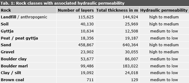
Tab. 1: Rock classes with associated hydraulic permeability
Image: Umweltatlas Berlin
Environmental Atlas Contact
Berlin Senate Department for Urban Development, Building and Housing
Mrs. Haag