Quality of Near-surface Groundwater 2000

Map Description

Electrical conductivity

The concentration intervals of conductivity follow the percentiles of the measuring network operated by the Senate within the “upper aquifer” GWL 2. According to Schleyer & Kerndorff (1992), concentrations above 840 µS/cm are said to be subject to „anthropogenic influences“, whereas – according to Kunkel et al. (2003) – those up to 1,000 µS/cm are said to be of „natural“ origin.

In the context of the regional assessment of the data stock from hydrogeological explorations (LUA 1996; the same data stock that was used in the surrounding area within the page segment) concentration ranges up to 500 µS/cm were considered to be “background values“ in Brandenburg. However, the current assessment of the groundwater condition in Brandenburg (LUA 2002) indicates that conductivities determined at the five measuring sites in the immediate vicinity of Berlin have increased in the mean time to 1,000 µS/cm and more. Values ranging from 600 to 1,200 µS/cm are regarded as “typical“ of Berlin (Fugro & Hydor 2002).

This tendency is also shown very clearly by the calculated area surveys. Concentrations in the range of 500 µS/cm and lower are seen in the urban area only in the mainly wooded suburban areas (Tegel and Spandau forests and south of the Müggelsee lake, but not in the Grunewald forest). In the surrounding area these ranges occur more frequently. Primarily in the northeastern part of the city this seems to be plausible even today. The value measured at the Zepernick measuring site in 2000 was still below 1,000 µS/cm.

Within the city, a tendency of groundwater conductivities increasing from the suburbs towards the city centre is noticed. Whereas in areas of confined groundwater (under glacial marl in the Barnim or Teltow regions) no significantly lower conductivities are seen compared to areas without confined groundwater (leaching fields do not show a clear influence either), areas with clearly increased conductivities (above 1,500 µS/cm) are concentrated in the densely built-up areas in the districts of Mitte (area around Nordbahnhof – a former train station), Prenzlauer Berg (Landsberger Allee / Storkower Straße), Kreuzberg (Gleisdreieck / Yorckbruecken), Schoeneberg and Wilmersdorf (Volkspark). These areas comprise land suspected of being polluted. The Wilhelmsruh industrial estate along the S-Bahn track with numerous polluted measuring sites and dumps can be mentioned as another area where increased contents were measured also for many other parameters.

Areas whose conductivity limiting values are exceeded are very rare and occur only in a few isolated core areas of the above-mentioned areas.

The area around Hahneberg in Spandau occupies a special position, because it is the largest area with values above the limit. Concentrations of almost all other parameters are also very high and therefore the area must be regarded as being clearly impaired. Hahneberg came into being as a rubble dump and has been identified as an area suspected of being polluted by hazardous substances. A number of groundwater measuring sites of the landfill programme have been set up in its vicinity, which all show clearly increased concentrations. The calculation results in areas whose parameters are linked with those in the vicinity of the northeastern industrial estate near Brunsbuetteler Damm.

However, conductivities ranging from 1,000 to 1,500 µS/cm (yellow areas) are relatively widely diffused within the city (including areas with open development) and can be called current „background noise“.

Chlorides

From the geochemical point of view, chloride is extremely mobile. Hence its action in groundwater resembles that of an ideal tracer, that is to say that in most cases it is not retained by permeable rock. Sources of increased chloride concentrations in groundwater may be wet salts, which are used by the city environmental services (BSR) during the winter season to improve road safety. This practice has been clearly reduced in Berlin in the last several years and is mainly limited to streets with rain water sewers. Markedly increased chloride contents of the groundwater, which are not caused by geogenic rising hypolimnetic water, may be regarded as indicators of isolated cases of wastewater discharge or pollution resulting from landfills. Specialized literature (Schleyer & Kerndorff 1992) refers to concentrations of more than 80 mg/l in the groundwater of North Germany as being “influenced by anthropogenic factors”. Members of the regional working-group on water (LAWA) describe concentrations up to 66 mg/l as „natural“.

Values up to 50 mg/l are described as background values in Brandenburg, whereas in Berlin values ranging from 14 to 95 mg/l are considered „typical” (Fugro & Hydor 2002) of the upper aquifer (only GWL 2). Brose & Brühl (1993) mention 9 to 69 mg/l as characteristic values for forest locations in Berlin. Due to glacial erosion of Rupelian, hydraulic contact with the lower saline water level became possible in several areas of Berlin. In principle, the rising of saline groundwater can be intensified by anthropogenic influences (relieving pressure by pumping water from layers above Rupelian). For specific locations in the Berlin area, this problem is of special importance owing to the intensive utilization of groundwater (drinking-water supply, individual water-supply installations, lowering of the groundwater level due to building work).

Within the city boundaries, the possibility of higher concentrations in the aquifers close to the surface due to geogenic salinification is limited; examples are an area in the northern part of the Neukoelln district or the main aquifer (GWL 2) in the area of Schmoeckwitzer Werder. Unfortunately, this could not be confirmed by data, since there are no measuring sites in these areas. In several catchment areas of Berliner Wasserbetriebe (Friedrichshagen waterworks, Beelitzhof), the impact of local saline water on wells is known. In problematic areas, these influences are countered by adapting pumping strategies. For the time being, an area-wide problem is not assumed to exist. The catchment areas of extraction galleries are continuously monitored by Berliner Wasserbetriebe and the problem of rising saline water due to possible climate change (relief of pressure owing to a more limited formation of new groundwater) will be monitored on an area-wide basis by including deeper measuring sites in Berlin’s basic measuring network.

Concentrations below 50 mg/l are almost exclusively found in the wooded suburbs. Also in Brandenburg, concentrations below 50 mg/l are found mainly in areas in the immediate vicinity of Berlin. But there are also large areas to the south of the city, where concentrations above 50 mg/l are found. They seem to be linked to the leaching fields that were mostly operated until 1990.

Within the city, areas with increased chloride contents are interrelated with those having increased conductivities. However, clearly increased contents of more than 100 mg/l are limited to small areas. Such areas exist only in Spandau (Hahneberg), Mitte (Nordbahnhof, a former railway station) and Prenzlauer Berg. Contents above the threshold value of 250 mg/l were identified only in one area (480 mg/l were measured at a measuring site to the northwest of Hahneberg). In the light of these findings, a significantly increased chloride pollution of the Berlin groundwater due to diffuse harmful substances cannot be assumed.

Sulphate

Sulphate is a rock constituent that is readily dissolved in water and relatively quickly leached out. Current anthropogenic sulphate inputs into the ground and groundwater are very high and of diverse origin. In Brandenburg, concentrations up to about 100 mg/l are regarded as background contents; Schleyer & Kerndorff (1992) presented similar findings (100 to 150 mg/l). Kunkel et al. (2003) mention contents of up to 200 mg/l.

Under forests, in contrast, contents corresponding in magnitude to the threshold value derived from TrinkWV (240 mg/l) were regarded as typical in the recent past. Kabelitz (1990) mentions concentrations of up to 1,200 mg/l in Berlin aquifers that date back to upper Pleistocene. Renger et al. (1989) give sulphate concentrations from 5 to 42 mg/l for precipitation measured in a stand of pine trees in the Grunewald forest. However, the reason for the markedly increased sulphate concentration in the Berlin groundwater are the numerous dumps of building and other types of rubble around the city that resulted from World War II (SenStadtUm 1986): the impact of domestic wastewater is also mentioned, but plays a secondary role (Wurl 1995). A characteristic feature of the mainly gypsum-like deposits is that they are scattered across the entire urban area in a more or less diffuse pattern. That is why the Berlin building rubble dumps must be regarded as forming the interface between diffuse and spot sources of inputs. Numerous very small (natural and artificial) cavities were also filled with large quantities of rubble.

We want to illustrate the impact of these dumps by way of an example: Siebert (1956) concluded that the huge quantities of debris and rubble that were dumped around Teufelsberg in the Grunewald forest in the mid-1950s did not affect the groundwater condition yet. In those days, a groundwater measuring site situated directly in the western runoff of Teufelsberg showed a sulphate content of around 50 mg/l. But in the context of the Hydrogeological Structural Model for the Tiefwerder waterworks (GCI & AKS 1998) it was pointed out that the sulphate concentration measured at the same point had increased to more than 400 mg/l in the meantime.

With the exception of small wooded areas, sulphate concentrations below 100 mg/l are no longer measured in the northwestern and southeastern parts of the city. In areas of Brandenburg that are extending to the south and west of the city, most sulphate values are above 100 mg/l. Values are above 180 mg/l in the entire inner-city area (the mean sulphate value being 114 mg/l). Spatial relationships to building rubble dumps exist in many areas (Wilhelmsruh, Spandau, Teufelsberg). The highest sulphate concentration (above 360 mg/l) is measured in densely built-up inner-city areas. An area of about 30 km2 extending along both banks of the lower reaches of the Panke River toward the east up to the Friedrichshain district is affected. In some places, sulphate concentrations of more than 800 mg/l are measured (for instance at Eberswalder Straße south of the Jahn sports field where a mean value of 872 mg/l was determined). The calculation of the retention time of percolating water showed periods of less than 50 years for that area on the southern edge of Barnim, so that the scenario that is based on the materials input caused by dumping after World War II seems to be plausible.

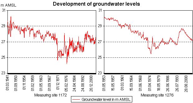
The extremely high sulphate content measured in the southwestern part of the Grunewald forest along the eastern bank of the Havel River is another special case. Here again, values up to 900 mg/l (872 mg/l at Havelchaussee and 922 mg/l in the Havel hills) were measured. At least for the latter measuring site, debris and building rubble dumps can hardly be considered as a cause. According to Fugro & Hydor (2002), the cause of such high contents is the groundwater depletion as a consequence of the water intake by wells operated by the Beelitzhof waterworks. This intake could have resulted in the aeration of formerly saturated areas and thus in the oxidation of sulphidic sulphur dispersed in the sediment. This explanation was also given by Sommer von Jarmersted (1992) for the extremely high sulphate contents measured at these sites. Furthermore, the strata-log sheet of one of these measuring sites includes sapropel strata from the Eemian warm period directly 19-25 m above the filter, which could be another source of sulphidic sulphur.

To check this hypothesis, we include the following figures showing the hydrograph curves of measuring sites 1172 and 1276. The elevation of measuring site 1172 is about 40 m, that of measuring site 1276 about 49 m. That is to say that in both cases the groundwater level curves, as referred to the elevation, range from 10 m to 20 m. At overall amplitudes of 5 m, the marked fluctuation of the groundwater surface (which is free in this case) is clearly shown. These amplitudes cannot be explained by natural causes. A clear decline of groundwater levels is seen at both measuring sites up to the late seventies, which can only be explained by an increase in the water intake by waterworks. Whether or not the extremely high sulphate content is indeed caused by the oxidation of pyrite can only be determined when a hydrogeochemical balance of the constituents of the groundwater, which has very high hardness but is not acidic, is drawn up. Other causes need to be investigated.

Fig. 1: Development of groundwater levels at measuring sites 1172 and 1276 (both located in the Grunewald forest)

Fig. 1: Development of groundwater levels at measuring sites 1172 and 1276 (both located in the Grunewald forest)

Potassium

Potassium is an alkali metal and – like sodium – highly reactive. Natural concentrations usually amount to only a few mg/l, the background value is between 3 and 4 mg/l (LUA 1996, Schleyer & Kerndorff 1992, the threshold value stipulated in the TrinkWV is 12 mg/l).

Apart from the weathering of silicate rocks, potassium is continuously introduced into the ground by the mineralisation of dead vegetable material. Agricultural manuring or fecal pollution (caused by leaking sewerage pipes) can also result in high values. From the geochemical point of view potassium is not very mobile since it may be absorbed by clay minerals. However, if these are not available – as in the mostly sandy sediments of the glacial spillway – the substance can easily get into the groundwater. It was established recently that this happens very often in Brandenburg; the limit laid down by the TrinkWV is already exceeded at numerous measuring sites (LUA 2002). This trend was also seen in the primary statistics based on the measuring sites in the main aquifer (GWL 2) operated by the Senate. Even though every second measuring site is still within the range of the geogenic background (50-percentile 3.2 mg/l), one in four measuring sites is already clearly influenced at concentrations above 7mg/l.

This is confirmed by the regional distribution pattern of the calculated concentrations. The relationship with areas of groundwater confined under glacial marl is clear. Here concentrations exceed only rarely values of about 6mg/l – not even in the densely built-up city centre at the southern edge of Barnim, which is characterized by high sulphate contents. An exception is the agricultural area around Lübars-Blankenfelde in the north of the city, where potassium contents of more than 12 mg/l are predominant even under glacial marl. The impact of a local rubble heap or polluted area in the meadows of the fen along Tegeler Fliess (potassium content of 26 mg/l at measuring site 10839) is another possibility.

In the glacial spillway, in contrast, concentrations measured in the inner-city area are almost everywhere above 6mg/l, in large areas even above 12 mg/l. Examples are the entire area to the north (Muenchehofe) and west of Mueggelsee lake along the Spree River up to Wuhlheide. In the Grunewald forest, in contrast, potassium values are low – an indication that the causes of input of potassium and sulphate are different.

The well-known Brandenburg potassium problem therefore exists also in Berlin and – just like the above-described sulphate contents – should not be underestimated.

Ammonium

Fairly high concentrations of ammonium, which sometimes exceed the limit of 0.5 mg/l stipulated in the TrinkWV, are often measured in the aquifers in North German unconsolidated rock. In Brandenburg, this concentration range was determined to be the geogenic background; in low-lying areas it is even somewhat higher (up to 0.8 mg/l). The reason for these ammonium concentrations is the reduced environmental condition of fine granular aquifers from the Quaternary Period. Influences of anthropogenic pollution (faeces, wastewater) can increase them. Ammonium occurs particularly frequently in low-lying areas with reduced (anoxic) conditions. The increased content is due to organic, peaty constituents of the sediment, from which nitrogen in combined form can be periodically discharged. That is why ammonium values in pure sands are frequently below 0.1 mg/l.

As stated above, variogram analysis of the absolute measured value of ammonium did not yield any correlations that could be interpreted, so that the indicator kriging approach using a threshold value of 0.5 mg/l was used. For ammonium, a clear correlation with areas featuring groundwater confined under glacial marl was found. The probability of exceeding the threshold values applying to the glacial-marl plateaus of Barnim and Teltow is rather low. However, in the glacial spillway lower values are mainly seen in areas of either glacigenic secondary sandy depositions to the west and east of the lower reaches of the Havel River or in intercalation strata of pure valley sands (such as in the Tegel and Spandau forests). In contrast to them, valley sands in the central stretches of the glacial spillway feature intercalation strata of silty and/or humous constituents. The values are particularly high in the effluent of the former Muenchehofe leaching field. For decades, large quantities of nitrogen were introduced into the aquifer – which is expressed by very high probabilities.

The surprisingly high ammonium contents across the city centre are due either to the diffuse disposal of unpurified wastewater into the underground of Berlin that went on for centuries or to current leakage from the sewerage system. Further investigations are necessary before a definite answer can be given.

Oxidizability

Permanganate consumption (measured as CSV manganese, converted to the oxidation equivalent related to O2 in mg/l) is used as a measure of inorganic and organic compounds dissolved in the groundwater. In non-polluted groundwater, the origin of most organic substances is the ground zone inhabited by various forms of life. Dissolved organic substances are sources of energy and carbon for microorganisms living in the groundwater and are therefore relatively quickly decomposed in the presence of dissolved oxygen. However, in many cases dissolved organic substances contained in the groundwater are caused by anthropogenic pollution (for instance by wastewater or synthetic organic compounds). In addition, large amounts of iron or manganese compounds are dissolved in fine-grained sandy-silty aquifers that in the form of reduced inorganic compounds also result in high CSV manganese values.

The geogenic background value in Brandenburg – just like the limiting value stipulated in the TrinkWV and the range that Schley & Kerndorff (1992) considered to be the beginning of anthropogenic interference – is about 5mg/l. In low-lying areas with boggy layers it may be slightly higher.

The Figure shows a clear regional correlation with the hydrogeological boundary conditions of the city zone: in the area of the plateaus, the values are within the normal range of concentrations, whereas in the glacial spillway they are generally increased. Values above 5mg/l were measured mainly along the Spree River in city-centre areas (Wuhlheide), the upper reaches of the Havel River and in Spandau. In those areas there exist both boggy sediments and anthropogenic interferences from industrial estates (Haselhorst, Siemensstadt).

Orthophosphate

Phosphorus is mobile only under anaerobic conditions and is bound in the soil mainly to clay minerals and metal hydroxide. In unconsolidated rock, values up to 0.2 or 0.3 mg/l orthophosphate (LUA 1996) are regarded as natural background contents. Higher phosphate contents in the groundwater are indicative of anthropogenic interferences and are, above all, problematic for the surface waters in the Berlin/Brandenburg region, since these are fed by groundwater to a large extent.

The figure shows the results of calculations done for the probability of exceeding the chosen threshold value of 0.3 mg/l, based on the indicator kriging technique (as for ammonium, the presentation of the calculation of the area based on the original data was dispensed with): As in the case of ammonium and oxidizability, the hydrogeological relationship is clearly discernible. The phosphate contents in the confined aquifers are always low (in most cases below 0.05 mg/l). Higher concentrations and thus a greater probability of exceeding the threshold value of 0.3 mg/l are discernible in the uncovered deposition beds in the glacial spillway and in particular in places where depositions of peat and muds from the Holocene period exist along water bodies. By drawing on the values furnished by the basic measuring network, this pattern was identified also in Brandenburg (LUA 2002). Organically-bonded or complexed phosphorus is easily transported by water that seeps into the ground, since organic anions block the sorption of phosphate.

In the Berlin region, this phenomenon appears mainly along the upper reaches of the Havel River (Henningsdorf, Heiligensee and Spandau) up to the area where the Spree River flows into the Havel River and in the area of the Spandau forest. Huge mud and peaty deposits are found everywhere in these areas. A surprising finding is that very high phosphate contents were measured in some places of the outlying area of Tegelort (on the eastern bank of Havel or of Tegel lake), for which no organogenic sediments were recorded in the General Geological Map 1 : 100,000 (LGRB & SenStadt 1995).

High phosphate contents were identified also in the catchment area of the Johannisthal waterworks; here again, thick Holozenic deposits exist. The high phosphate contents measured in the area north of Müggelsee lake, in contrast, are attributable to pollution caused by the Münchehofe sewage treatment plant. Increased phosphate concentrations were also measured in the entire Berlin catchment area of the Dahme River.

Boron

Boron is a problematic substance in the groundwater. Being an ingredient of detergents (perborate), it is released in large quantities into the environment via the wastewater. Owing to its low geogenic concentration (except for water salinified by deep saline), it is a suitable indicator of anthropogenic influences exerted on the groundwater. According to estimates, two thirds of environmental boron is of anthropogenic origin (LfU 2001a). It is used in cleaning agents because of its disinfecting and bleaching action. It is also a constituent of fertilizers. Because of its numerous uses, boron is often found in wastewater. It is introduced into the groundwater via leaking wastewater systems and waste disposal facilities, which release it into surface water that seeps into the groundwater. That is why increased boron concentrations are measured mainly in areas with high population and industrial densities.

The threshold value stipulated in TrinkWV is 1,000 µg/l. Influences are detectable from contents of about 80 µg/l (Schleyer & Kerndorff 1992). No area-wide investigations of the groundwater boron content are available for Berlin yet. Investigations performed up to now show correlations with the sulphate contents; it was found that the closely built-up city-centre areas have recognizably higher boron contents. These spatial inhomogeneities without any clear reference to the additional information are found in the Berlin urban area: Particularly low concentrations were determined in Grunewald forest and in the north (Tegel forest, Frohnau), especially high ones along the inner-city stretches of the Spree River, but also in the agricultural area around Luebars and Blankenfelde. In the city-centre, almost all measurements showed contents above 100 µg/l and thus a detectable diffuse influence, which might be due to leaky sewerage systems. An analysis of the values measured at particularly polluted measuring sites (above 250 µg/l) should be performed.

Overall view

The purpose of the work was to translate information obtained for the groundwater condition of some sources to the entire area. Measuring sites that are part of measuring networks in Berlin and Brandenburg, data of pollution-related special investigations, networks operated by Berliner Wasserbetriebe and data from hydrogeological explorations were used for that purpose. Measuring sites were chosen on the basis of their assignment to the main aquifer in the region (GWL 2) that is used for water intake; if multiplexing intake points in the same aquifer are used, the uppermost measuring site was chosen. A total of about 1,400 measuring sites were investigated and included in the study. This corresponds to an average density of 1 measuring site/km2.

Eight parameters were selected on the basis of their hydrochemical relevance for the risk resulting from diffuse sources of pollutants. Much attention was given to the verification and preparation of data. In view of the fact that especially the pollution-related special measuring sites are clustered in a restricted area with high hydrochemical variability, the individual measured values or analyses had to be checked/verified individually before they were included in the geostatistic analysis. Values that were not plausible from the spatial and temporal points of view were eliminated from the database. Analyses that mostly date back to the second half of the 90s were then used to determine the arithmetic mean per measuring site and parameter. Additional spatial information was used to facilitate the interpretation of calculation results, however, due to the small-scale variability within the Berlin conurbation they were not directly included in regional analyses.

The database was then subjected to variogram analysis. With the exception of ammonium and orthophosphate, the other six parameters show a correlation between variability and the distance from the measuring site so that the ordinary kriging approach could be used. For ammonium and orthophosphate the proportion of measured values below the detection limit is also relatively great so that indicator coding with subsequent regionalisation had to be performed. In that case, the result was not concentration-oriented, but furnished information on the probability of exceeding a selected threshold value.

The results of the area calculation show very clearly the extensive area from which material was introduced into Berlin’s groundwater close to the surface over many years: whereas pollution by chloride and boron is limited to specific areas, large parts of the Berlin urban area are affected by markedly increased concentrations of sulphate, which are clearly exceeding the threshold value stipulated in the Drinking Water Ordinance (TrinkWV) – the primary cause is the large-scale disposal of building rubble and debris. In the case of ammonium and potassium, besides geogenic causes such as mucky sediments, other anthropogenic sources such as wastewater disposal in the past or current leakage from the sewer system, must be considered.