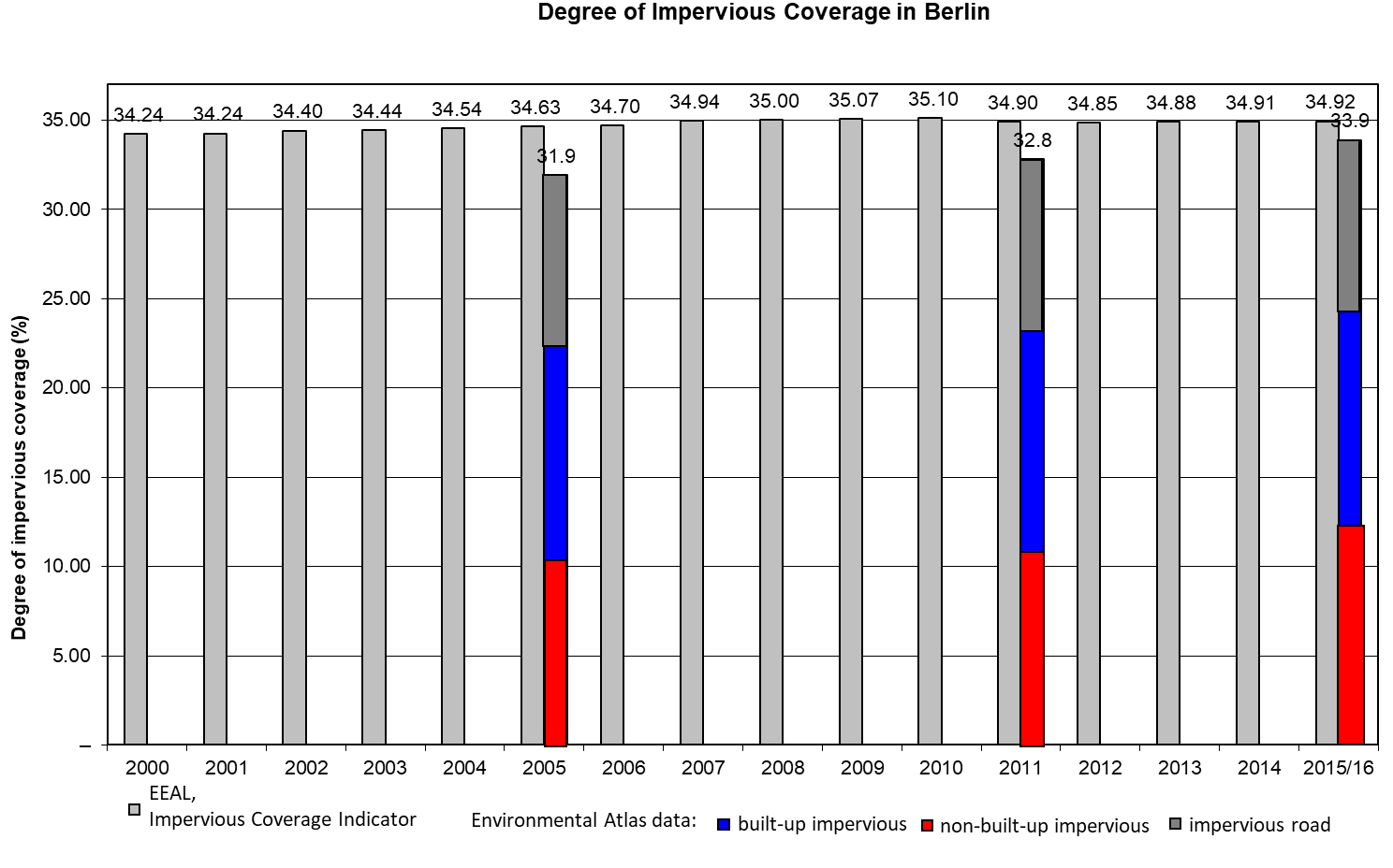
Comparison of the impervious coverage data for 2005, 2011 and 2016 with the “Impervious Coverage Indicator” of the Working Group on Integrated Environmental and Economic Accounting of the German States (EEAL)
The impervious coverage value for Berlin of the Working Group on Integrated Environmental and Economic Accounting of the German States (EEAL), developed by the Federal-State Commission on Soil Protection (LABO) on the basis of the sustainability indicator “land consumption for residential and traffic areas”, is juxtaposed to the results of the Environmental Atlas.
The data survey of degrees of impervious coverage by state is based on official land statistics, in which estimated degrees of impervious coverage are assigned to various use categories of residential and traffic areas, modified in accordance with residential density of the areas, and then used as a factor in calculation. In this way, impervious coverage data can be generated on an annual basis. The data on development of impervious coverage in the states are updated annually (EEAL 2016).
Accordingly, the proportion of impervious coverage in the total area of Berlin rose from 34.24 % in 2000 to 34.92 % in 2015, and thus increased by 0.68 % in 15 years, which comes to an annual rate of increase of 0.05 %. The increase of impervious coverage to reach 35.10 % by 2010, has seen a slight backward trend over the last five years.
The absolute increase in impervious coverage, amounting to approx. 31,140 ha, was thus 770 ha in those fifteen years.
Figure 9 shows the rate of impervious coverage of the Environmental Atlas in 2005, 2011 and 2016, compared with the annually generated data of the EEAL.
Neither approach ascertains impervious coverage precisely; both work with different methods and different goals, and, to a certain extent, with estimates and assumptions.
While the EEAL approach gives the current (2015) overall impervious coverage of Berlin as 34.92 %, the Environmental Atlas mapped only 33.9 % of the city as impervious in 2016.
Under the procedure of the Environmental Atlas, the built-up impervious coverage area was derived directly from a number of different building stock data sets (ALK only for the years 2005 and 2010), and hence has a very high degree of precision, while the non-built-up impervious coverage area, as described above, is determined from satellite imagery. Hence, the above-mentioned error sources must be methodologically taken into account.
By contrast, the EEAL approach operates from the outset with estimates for certain use classes, which are moreover nationally uniform, and hence do not take regional particularities into account. For instance, the elimination of the area of Tempelhof Airport for the category of traffic areas at the time of its closure would have led to a change in the statistical situation, in spite of the fact that the degree of impervious coverage did not actually change.