Depth to the Water Table 2020

Introduction

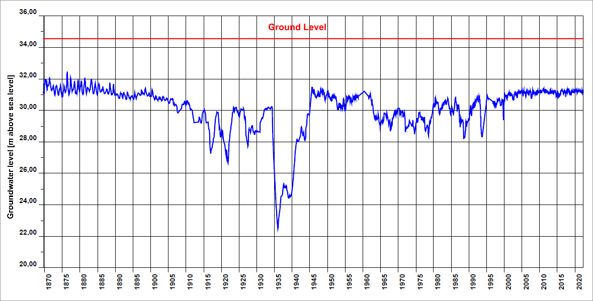
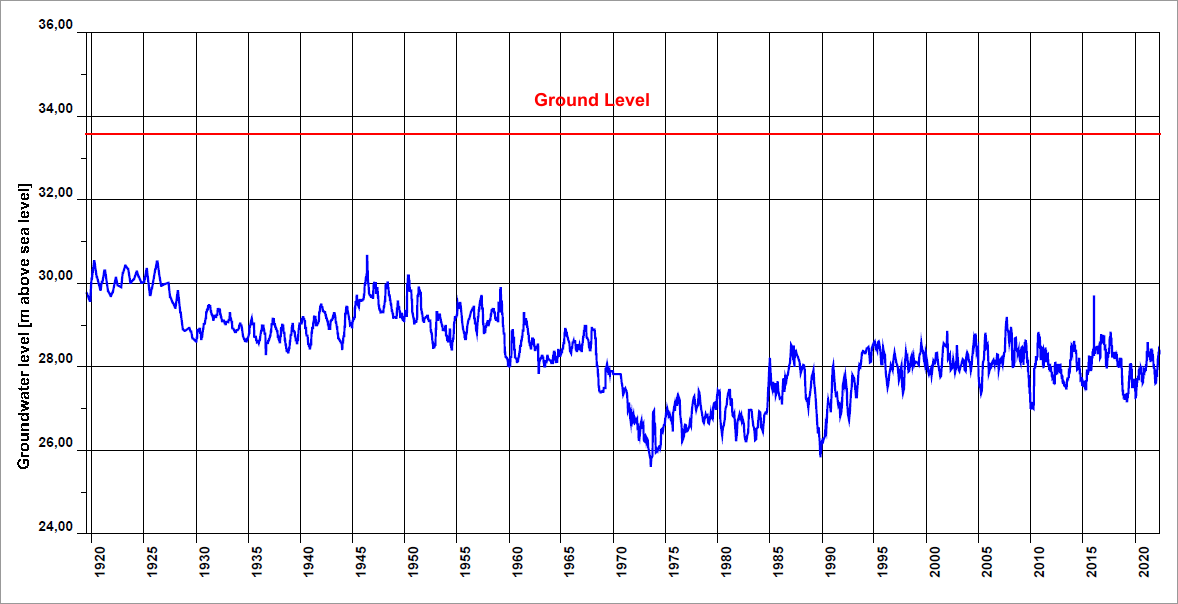
Groundwater levels in a metropolitan area like Berlin not only depend on natural factors, such as precipitation, evaporation, and underground runoff, but are also strongly influenced by human factors, such as groundwater withdrawal, construction, surface permeability, drainage facilities, and recharge.

The main reasons for withdrawal are the groundwater production by public water suppliers, private groundwater withdrawals, and groundwater extraction at construction sites. Groundwater recharge occurs primarily through precipitation (cf. Map 02.17), shore filtration, artificial recharge with surface water, and the return of surface water to groundwater as part of construction measures.

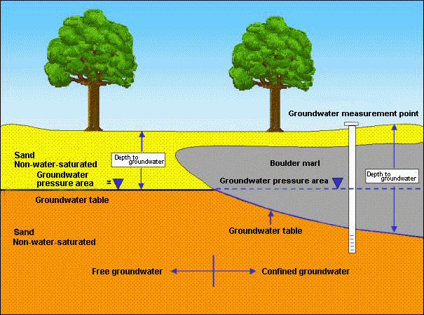
Berlin has two groundwater storeys. The lower storey carries salt water and is hydraulically separated from the upper storey by about 80 metres of clay, with the exception of isolated holes in the clay layer. The upper storey carries freshwater and has an average thickness of 150 metres. It is the source of Berlin’s drinking (potable) and industrial (non-potable) water supply. This storey consists of loose sediments, alternating between permeable and cohesive sediments. Sand and gravel (permeable layers) form groundwater aquifers, while clay, silt, boulder marl and gyttja (cohesive layers) act as aquitards (SenGUV 2007).

How deep the groundwater surface lies in the subsoil varies depending on the (usually slight) groundwater gradient and the terrain morphology (cf. Fig. 1).

Fig. 1: Hydrogeological definition of depth to the water table for unconfined and confined groundwater conditions

Fig. 1: Hydrogeological definition of depth to the water table for unconfined and confined groundwater conditions

The depth to the water table (depth to groundwater) is defined as the perpendicular distance between the ground level and the groundwater surface (DIN 4049-3). If the aquifer is covered by relatively impermeable, cohesive layers (aquitards, such as boulder marl), so that the groundwater cannot rise to the level that its hydrostatic pressure would dictate, it is considered to be confined. In this case, the depth to the water table is defined as the perpendicular distance between the ground and the groundwater surface, which is then the lower edge of the groundwater-obstructing boulder marl or the upper edge of the aquifer underneath (cf. Fig. 1).

The Map “Depth to the Water Table” provides an overview of how areas with the same depth classification (Hydor 2009, Gerstenberg 2009) are distributed across the city. It was calculated based on low groundwater levels of May 2020 and applies to the closest aquifer near the surface with a permanent water supply. This is primarily the main aquifer used for water supply in Berlin (Aquifer 2, according to the classification of Limberg and Thierbach 2002), which is unconfined in the glacial spillway and confined in the plateaus. In the area of the Panke Valley, the depth to the water table refers to the groundwater level of Aquifer 1, however, as it is the uppermost, planar aquifer. The Panke Valley aquifer lies above the main aquifer.

Areas with a shallower depth to groundwater (up to about 4 meters) are of particular importance. Soil pollution in these areas can quickly lead to a deterioration in groundwater quality, depending on the nature of the covering layers (permeable or non-permeable overburden) above the groundwater. The Map “Depth to the Water Table” thus forms an essential basis for developing the Map “Protective Function of Groundwater Coverage” and is included as a thickness parameter in the Map “Dwell Time of Seepage Water in the Non-Saturated Zone” (cf. Map 02.16 the properties of the geological overburden on the depth to groundwater data makes it possible to distinguish between areas with different protective functions of the overburden.

Information on the depth to groundwater also supports the assessment of where groundwater affects vegetation. The influence of groundwater on vegetation depends on the rooting depth of the plants and, depending on the type of soil, the capillary rise of the groundwater. The depth to which trees can use groundwater to some extent is usually given as four metres for Berlin conditions. Wetland vegetation often depends on groundwater as a water source, and requires a depth to the water table of less than 50 cm.

Compared to the Map “Depth to the Water Table” from 2020, which is discussed here and focusses on low groundwater levels, the Map “Depth to the Water Table 2009” presents medium groundwater levels.

Development of Groundwater Levels

The groundwater level in the city has been artificially manipulated in many ways. The first lowering of the groundwater level and the draining of wetlands in the Berlin area can be traced back to the drainage of marshes such as the Hopfenbruch in Wilmersdorf in the 18th century. In the 19th and 20th centuries, further areas were drained, due to the construction of canals. The groundwater was then further lowered or subjected to strong periodic fluctuations with local amplitudes of up to 10 metres. Reasons for this were the increased use as drinking and industrial water, water retention during construction measures and the reduced rate of groundwater recharge where the soil had been paved or otherwise rendered impervious.

Until the end of the 19th century, the groundwater level was largely subject only to the natural seasonal fluctuations caused by precipitation. From 1890 until the Second World War, the increasing water use of the rapidly growing city as well as groundwater retention shaped the groundwater development. Large groundwater reservoirs, created for the construction of the underground (U-Bahn) and city rail (S-Bahn) (e.g. Alexanderplatz, Friedrichstraße) and other large buildings, lowered the groundwater in extensive areas of the city centre by up to eight metres over long periods of time. As a result of the collapse of the water supply after the end of the War, the groundwater almost returned to its natural conditions (Fig. 2).

In the period that followed, from the early 1950s to the early 1980s, the groundwater was again continuously lowered extensively as a result of increasing withdrawals. This trend was particularly noticeable in water catchment areas (waterworks facilities). In addition to the general rise in water consumption by private households, this development was also caused by construction activity (rebuilding of the severely destroyed city, construction of the underground, and large-scale construction projects). The expansion of the water extraction facilities of the municipal waterworks in West Berlin was completed by the beginning of the 1970s. In the mid-1970s, the expansion of the Friedrichshagen Waterworks in East Berlin began in order to supply water to the new large estates areas in Hellersdorf, Marzahn and Hohenschönhausen.

Fig. 2: Development of the groundwater level at measurement point 5140 in Mitte, Charlottenstraße (blue line) compared to the ground level (red line) since 1870

Fig. 2: Development of the groundwater level at measurement point 5140 in Mitte, Charlottenstraße (blue line) compared to the ground level (red line) since 1870

Permanent, large and deep cones of depression have formed in water catchment areas around the wells of the waterworks. The pumping rates of most waterworks fluctuate throughout the year. This is accompanied by, at times considerable, fluctuations in groundwater levels. As early as the beginning of the last century, the Riemeistersee and Nikolassee lakes were drained by water withdrawals from the Beelitzhof waterworks. The groundwater level of the Schlachtensee lake sank by two metres, and that of Krumme Lanke by one metre. To counteract this, water has been pumped from the Havel river into the Grunewald lakes since 1913, reversing the natural direction of flow. It is only through this measure that the wetlands Hundekehlefenn, Langes Luch and Riemeisterfenn as well as shore areas of the lakes could be preserved.

The cones of depression around the well groups on the Havel have an impact far into the Grunewald forest. The groundwater level at Postfenn, for example, sank by 3.5 metres between 1954 and 1974, and at the Pechsee lake in the Grunewald by 4.5 metres between 1955 and 1975. Withdrawals by the well groups on the banks of the Havel have led to severe drying out in the root zone of plants even in the immediate vicinity of the Havel.

Some wetlands and peatlands have been restored by flooding and the introduction of surface water for percolation, to mitigate the negative effects of the lowered groundwater level. Examples include the nature reserves Großer Rohrpfuhl (large pool) and Teufelsbruch (marsh) in the Spandauer Forst, the Teufelsfenn (fen) in Grunewald and the Lietzengrabenniederung (lowland) including the Bogenseekette (chain of lakes) in Pankow.

Another area where the groundwater level has dropped is the Spandauer Forst, withdrawals by the Spandau waterworks have increased considerably since the 1970s. With the aid of a groundwater recharge facility, commissioned in 1983, the groundwater level was gradually raised again through the infiltration of purified Havel water. By May 1987, the groundwater level in the Spandau Forst had risen by an average of 0.5 – 2.5 metres. Measures to recharge the groundwater in this area were somewhat restricted again because of flooded basements in nearby residential areas. With the simultaneous increase in the withdrawal quantities of the Spandau waterworks, the groundwater level dropped again until 1990. A further reduction in pumping rates caused the groundwater level to rise again thereafter (cf. Fig. 3).

Fig. 3: Development of the groundwater level at measurement point 1516 in Spandauer Forst (blue line) compared to the ground level (red line)

Fig. 3: Development of the groundwater level at measurement point 1516 in Spandauer Forst (blue line) compared to the ground level (red line)

Generally, a resurgence of groundwater levels has been observed in West Berlin since the end of the 1980s. This was primarily due to three measures that counteract the falling groundwater levels:

  • The increase in artificial groundwater recharge using purified surface water in areas near the waterworks (Spandau, Tegel and Jungfernheide) led to a smaller drop in groundwater levels.
  • The enforcement of groundwater returns in cases of groundwater retention measures accompanying large construction projects has lowered the burden on the groundwater balance.
  • The introduction of groundwater withdrawal fees led to a more economical use of groundwater as a resource.

Following the reunification in 1989, the raw water production of the Berlin Waterworks (BWB) decreased, due to lower water consumption. The eastern areas were significantly impacted by this. Five small Berlin waterworks ceased production completely between 1991 and 1997, i.e. Altglienicke, Friedrichsfelde, Köpenick, Riemeisterfenn and Buch. As a result, groundwater levels rose again throughout the city until the mid-1990s.During this period, the groundwater recharge caused waterlogging in numerous basements that had not been properly sealed. The damage was so extensive in two areas (Rudow, Kaulsdorf) that groundwater regulation measures were introduced.

In September 2001, drinking water production was also temporarily discontinued at the Johannisthal and Jungfernheide waterworks; at the latter, the artificial groundwater recharge was stopped in addition. As part of groundwater management, groundwater is, however, still withdrawn at the Johannisthal site, so as not to jeopardise ongoing local remediation of contaminated sites and construction measures. At the Jungfernheide site, a company has been managing the groundwater to protect its buildings since January 2006.

The total volume of water pumped by the waterworks for drinking water purposes in Berlin has dropped by over approx. 40 % in 30 years: in 1989, 378 million m³ were withdrawn, whereas in 2020 only 234 million m³ were pumped.