The inclusion of climatological aspects in evaluating environmental situations of urban metropolitan areas and their spatial planning requires a definition of the term urban climate. Urban climate is understood, according to Schirmer et al. 1987, to be “the strongly modified mesoclimate (local climate) of cities and concentrated industrial areas in comparison to their surrounding areas. It encompasses the entire volume of near-surface air layers above and in the direct vicinity of the city and its urban borders. It is caused by the type and density of building, the heat storage capacity of the soil, a lack of vegetation, a changed water balance and increased emissions of waste gasses, aerosols, and heat wastes.”
Approaches to Evaluation and Investigation
Definite limit values and guidelines for evaluating climate situations analogously the air quality values of the Federal Air Pollutuon Control Law are lacking. Recommending character possesses a guideline of the VDI- (Association of Engineers)Commission on Air Pollution Prevention (cf. VDI (Association of Engineers) 3787 sheet 2 1998 ). The target of this guideline is to offer evaluation procedures of the human-biometeorology as a standard for the integration of bioclimate-affairs in city- and regional-planning. The human-biometeorology is engaged in the effects of weather, climate and air hygiene on the human organism. In the present first part of this guideline, the human-biometeorological complexes are put together and the suggested evaluation methods for the climate area are explained. Especially, focus is on the thermal action complex, to put this theme into the city- and regional-planning processes, in order to secure healthy residential- and working-conditions. Planning questions from the bioclimatological view can be treated with its help. The ideal urban climate to be striven for is one largely free of pollutants. It offers its inhabitants as great a diversity of atmospheric conditions as possible, and avoids extremes (cf. Deutsche Meteorologische Gesellschaft 1989 – German Meteorological Society 1989).
The classical climatological research methods for surveying urban climate are mobile field surveys, both vehicular and pedestrian (cf. Maps 04.02 – 04.05). Another method is the calculation of individual surface element temperatures (roofs, streets, tree crowns, etc.) by means of Thermal-Infrared (IR) Imaging. It proceeds from the physical principle that all objects give off heat radiation corresponding to their surface temperatures (cf. Methodology).
Indicators
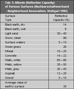
Heat radiation, and thus surface temperature as component of an object’s heat balance, is of great importance as a control quantity for the heat balance of the earth’s surface. The primary daytime determinant is the short wave radiation spectrum, particularly the direct irradiation of solar energy onto an object’s surface, and the absorption or reflection of this energy (reflection = albedo, cf. Table 1). The only influence affecting the thermal radiation behavior of an object at night is the long wave spectrum and the soil heat flux.