Age and Inventory Structure of the Forests 1990

Methodology

The present map, like the map from the 1985 Environmental Atlas, refers only to the main tree layer, and, to the extent available, to residual and/or seed-tree stands.

In the age-class forest, the main tree layer is understood to be that layer of the forest which is the most important from the point of view of forestry, and which is the most characteristic from a visual point of view. In the main tree layer, the trees raised by the forestry operation grow to harvest maturity; the age of the main tree layer can vary greatly. After the afforestation of a clear-cut area, the one-year-old seedlings already form the main tree layer, while old self-contained stocks can be as much as 140 years and older. With the progressive build-up of a near-natural forest with a mix of tree-ages, it is becoming ever more difficult to maintain the mapping method of main tree layer and undergrowth developed from the point of view of forestry, because the clearly recognizable stratification is purposely being broken up. The main tree layer consists of main and subsidiary tree species. The main tree species is the tree species which currently characterizes the stand. The subsidiary tree species are accompanying species which occur alongside the main tree species in the main tree layer.

Seed-trees are trees, usually individuals, which are of an age greater than that of the main tree layer. Residual stands are trees of another tree species, which occur only in isolation in the main tree layer. Both serve mostly as seed providers for the natural new generation. The layer of young trees which do not yet constitute stands are called undergrowth. With near-natural forestry, they should arise mainly from the natural regeneration (e.g., through seeding from the seed trees). A change in species composition can first be ascertained In the undergrowth, as the first successes of 14 years of near-natural forestry show. This layer is not shown on the map for technical reasons. Also, the herbaceous layer is not shown, because it is not ascertained during the forestry stocktaking.

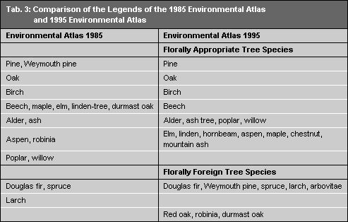
In contrast to the 1985 Environmental Atlas, the tree species are divided into florally foreign and florally appropriate species and/or species groups. For the formation a near-natural forest, only site-appropriate and florally appropriate tree species should be introduced. In the Berlin area, pine and oak are the major domestic species. The soft-wood deciduous moist-site trees, such as alder, ash, poplar and willow, are included in a class, as are such precious-wood species as elm, linden, hornbeam, maple, aspen, chestnut and mountain ash, which occur in the Berlin forests traditionally as mixed-stand tree species. An example of a florally foreign (i.e. not domestic), but site-appropriate species is the durmast oak. The Douglas fir can be considered florally-foreign and site-inappropriate. It was introduced because of its fast growth; however, it cannot regenerate under Berlin site and climatic conditions. As a result of the new break-down and the changed legend in the Environmental Atlas, the red oak was, for instance, removed from the class of oaks and added to the class of a florally foreign tree species (cf. Tab. 3 and Tab. 10). A contrast of the old and the new legends in Table 3 elucidates the changes.

Tab. 3: Comparison of the Legends of the 1985 Environmental Atlas and 1995 Environmental Atlas

Tab. 3: Comparison of the Legends of the 1985 Environmental Atlas and 1995 Environmental Atlas

The representation of the age structure is shown according to three age classes (A.Cl.):

Age class : 1 0 – 40 years,

Age class : 2 41 – 80 years,

Age class : 3 > 80 years.

By contrast to the 1985 Environmental Atlas, the subsidiary tree species, too, are shown in this map according to their respective age class.

The main tree layer with the main and subsidiary tree species is represented in the respective district in the pertinent section and subsection (if present), i.e. in the respective position in the forest.

In order to bring together the mass of the existing information into a format readable in a map, the data evaluation was undertaken according to the following criteria:

  • The percentage shares (ratios) of the various tree species for a reference area (total area of the position in the forest) are shown, rounded up or down to 5 %-stages.
  • The minimum share for the display of a class is 10 %; if the proportion is smaller, the class is added to the share the main tree species.
  • If several classes together have an area share of over 10 %, they are represented as “others tree species” without an age indication (cf. 1 in Tab. 4).
  • Different age classes of a tree species within a reference area, which each have shares of under 10 %, are summed up and represented under the older age class (cf. 2 in Tab. 4).
  • Different age classes of a tree species, of which one (or two) has an area share of under 10 %, are grouped together under the age class with the larger area (cf. 3 in Tab. 4).
Tab. 4: Examples for the Summary of the Ratios of Tree Species

Tab. 4: Examples for the Summary of the Ratios of Tree Species

The ratio of the tree species at a given position in the forest could not be taken directly from the Waldfonds data base, but had to be calculated separately (cf. Tab. 5).

Tab. 5: Example from the Available Data (Buch District) for the Calculation of the Ratio of Tree Species

Tab. 5: Example from the Available Data (Buch District) for the Calculation of the Ratio of Tree Species

The survey of the West Berlin Forsteinrichtung distinguishes according to stands, which, however, are not delimited spatially on the corresponding map. So the respectively occurring species were grouped together on a subsection or segment level and the ratio was calculated anew. For the example area (cf. Tab. 6), four stocks and reference sizes were distinguished to obtain ratios, which, however, are all referenced to Section 67 a in terms of total area. The occurrence of the species was summed accordingly for display on the map.

Tab. 6: Example for the Recalculation of the Ratio in the Grunewald Forest Agency, Dreilinden District, Section 67a

Tab. 6: Example for the Recalculation of the Ratio in the Grunewald Forest Agency, Dreilinden District, Section 67a

With the exception of some federal forest areas, only those areas are shown which belong to the Berlin Forests and are used as forests. This includes also non-wooded areas which are property of the forests, but not forested. In cooperation with the State Forestry Agency, these have been included if they display a forest-like character (e.g. nature reserves in the forest).