Soil Associations 2015

Methodology

Developing the First City-wide Map of Soil Associations

Starting Point

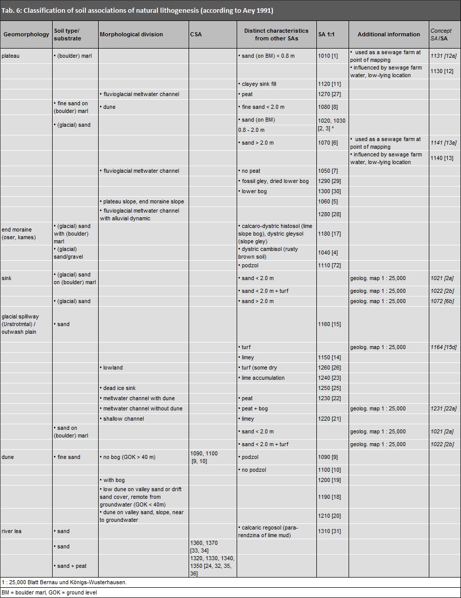
Aey (1991) wrote a guide on how to prepare a Concept Map of Soil Associations for the entire city. This guide was based on: the method described by Grenzius (1987) for preparing a Soil Association Map for West Berlin, and the Map of Soil Associations by Grenzius, which was transferred into the spatial reference system of the Urban and Environmental Information System (Informationssystem Stadt und Umwelt, ISU) by Fahrenhorst, Haubrok, and Sydow (1990). No Soil Association Map of this or a similar kind existed for East Berlin. The bases for the development of the soil association map of West Berlin were the excavations and drilling stock samples conducted in all of West Berlin. These were conducted in forest plantations and agricultural areas under consideration of geomorphological-hydrological conditions, and, in populated areas, under consideration of uses. All basis rock and most uses, with the exception of industrial areas, were surveyed several times, and appropriate soil-scientific mapping was carried out. Based on the analysis of this mapping, conclusions were derived for soil conditions in unmapped areas.

The comprehensive soil-scientific studies used for the Map of Soil Associations in West Berlin have verified the Soil Map for many areas, such as forest and agricultural areas (farmland). The map is only verified partially, however, for areas linked to fewer soil-scientific studies. Such detailed soil mapping for East Berlin, however, only existed for forests. The present map is thus to be regarded as a verified map only for these areas and as a concept map for all remaining areas. Mappings for further individual areas were added at a later stage. All derivations and determinations of soil associations for East Berlin – excluding forests – had to be derived from existing material, such as geologic and topographic maps, soil maps, and data on land use, etc. The accuracy, content, and age of this material varied greatly.

More precise classification models for soil associations, as well as the definition of new soil associations not described by Grenzius, were enabled both by maps and soil studies conducted in West Berlin after the publication of the West Berlin Soil Association Map, and existing soil maps for East Berlin, particularly for forest areas.

Since a scale of 1 : 50,000 does not allow the spatial distribution of individual soil types to be differentiated in sufficient detail, Grenzius’ methodology for soil associations was retained which involves the selection of unifying geomorphological units. Soils of spatial and material coherence are combined as soil associations.

In conclusion, the whole map should be considered a Concept Map with some verified areas (partially verified concept map) only, which exclusively focuses on pervious soils.

Naming

The naming of the soil associations was based on the interactions of characteristic soils. The first and last soil of each soil association were specified, and, usually, one of the soils that characterizes material translocations (Grenzius 1987). This interacting system, or the link between soils in areas still extensively near-natural is characterized in the map legend by “-”.

Near-natural soils are found only in loosely populated areas.

The structures of soils in populated areas have sometimes been greatly altered by human intervention. These anthrosols appear randomly next to each other and are connected in the legend by “+”.

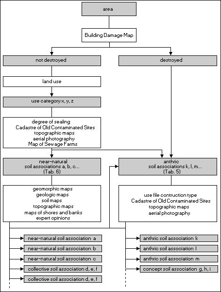
The legend is structured according to the degree of anthropogenic influence on and alterations of the soil. Near-natural soil associations are listed at the beginning; first the terrestrial soils, followed by the semi-terrestrial soils. Soil associations of anthropogenic aggradations and erosion are listed at the end. (Translator’s note: “aggradation” describes soils and materials which have been placed somewhere by natural processes (glaciers, water flows) or human actions. Anthropogenic aggradations include deep landfills (waste and debris depots, etc.), and shallow landfill of upper layers (playgrounds, building construction sites, street construction, etc.))

Drawn Borders

Borders were drawn between soil associations following reliefs in ridges and sinks. Neighbouring units can hence display the same starting and concluding elements. The area delineation of soil associations also had to conform to the Berlin Digital Spatial Reference System based on block and block segment areas of homogeneous use. If this process led to great losses of information, particularly in non-built-up and loosely built-up areas such as forests, agricultural areas, and settled areas with low degrees of impervious soil coverage, these block map areas were divided further, according to the borders of the soil associations. The decisive factors in these cases were the borders of geomorphological and geological units, contour lines, soil types (detail map), and aggradation borders. The factors for the delineation of anthropogenic soil associations were land use and the borders of aggradation or erosion. The further subdivision of soil associations thus directly influences the formation of block segments in block maps 1 : 5,000 and 1 : 50,000 (ISU5 and ISU50, Spatial Reference Environmental Atlas) and their continuous updates.

Near-natural and Anthropogenic Soil Associations

Determining factors for soil development are parent material, prevailing soil type, relief (slope, sink, channel, gradient etc.), water and climate conditions, as well as the degree of human influence. Anthropogenic influences are characterized by aggradation of natural soil material and non-natural materials (e.g. war debris, construction debris, slag and cinders), and erosion of natural soil. Important measures for anthropogenic alterations in soil include present and previous use, and the degree of impervious soil coverage. The map only shows pervious soils, independent of the degree of impervious soil coverage. The latter is used only to support the analysis of the degree of anthropogenic alterations of pervious soils in this area.

Near-natural soil associations are characterized by typical soil types, geomorphological structures, substrate/ soil types, and the influence of water. There are few alterations caused by humans.

The soil structure and soil associations of anthropogenic soil associations are not influenced by the topographical relief but rather by type of use, as well as the occurrence and type of aggradations. Some transitional forms still retain the characteristics of parent material, geomorphology, groundwater levels, and some natural soils. This is the case at military training areas, former surface mining sites, cemeteries, and levelled sewage farms.

Tab. 4 presents the effects human intervention has on soils. It classifies the urban area into various soil association categories (anthropogenic soil associations) under consideration of historic and current uses, damage to buildings in the Second World War, the type of construction, and the degree of impervious soil coverage.

Landscape Segments, Land Uses and Effects on Soils

Tab. 4: Landscape segments, land uses and their effects on soils

Soil Associations / Collective Soil Associations / Concept Soil Associations

The near-natural and anthropogenic soil associations defined for West Berlin by Grenzius were transposed onto East Berlin with the aid of existing data bases, and inferred conclusions for comparable areas, such as geomorphology, use, water conditions, etc. Problems occurred in areas where soil associations could not be derived and thus classified based on existing data bases, or where combinations of uses and geomorphology appeared that were not considered or did not exist in West Berlin. Examples of these areas are former sewage farms, sinks in plateaus, and mapped end moraines podzols. Besides the soil associations included in the Soil Association Map of West Berlin, the availability of appropriate mapping was used to develop new soil associations. In the case of insufficient pre-existing information, concept soil associations and collective soil associations were developed. The soil associations used in the map thus have three different levels of differentiation and characterization:

  1. Soil Associations (SA) – Soil associations in dependence on geomorphology and use. These can be verified by field studies in the form of detailed maps, key profiles, and soil profile studies.
  2. Collective Soil Associations (CSA) – These soil associations are collective, as insufficient data material for East Berlin does not allow for a differentiated categorization of individual soil associations within the collective soil association.
  3. Concept Soil Associations – are soil associations which do not exist or which have not yet been verified in West Berlin. They are a combination of use and geomorphology, such as levelled sewage farms. They have not yet been verified by soil studies.
Classification of Soil Associations

Fig. 1: Classification of Soil Associations, Schematic Depiction of Procedure

Categorization of Soil Associations

The categorization of soil associations was carried out in several steps:

  1. The actual use of each area was extracted from the land use data record. Each type of use category was linked to a specific model pattern on which the categorization of soil associations was based (cf. Fig. 1).
  2. Areas were defined as having mainly naturally developed soils or highly anthropogenic soils. Land use and degree of impervious coverage were used as criteria to pinpoint the extent of anthropogenic alterations of soils. Other factors of determination were existing data material such as the cadastre of old contaminated sites, geologic and topographic maps of various ages, building damage maps, etc. (cf. Tab. 5).
  3. For areas with hardly altered soils without aggradations or erosion, and a degree of impervious coverage of < 30 %, or a degree of impervious coverage of < 25 % at new, large area construction areas, soil associations were categorized into near-natural soils according to the model pattern in Tab. 6.
  4. Areas with a degree of impervious coverage of >= 30 %, or >= 25 % at extensive areas of new constructions, were classified as highly anthropogenic soil associations, depending on the type of use and the type of construction (cf. Tab. 5).
Classification Guidelines for Soil Associations

Tab. 5: Classification guidelines for soil associations, in dependence on use category and degree of impervious coverage

The classification rules presented in the figures and tables are general guidelines. It was often impossible to classify soil associations precisely, based on insufficient information on current land use or the degree of impervious coverage. Decisions hence had to be made on a case-by-case basis. The classification of soil associations in residential areas considered the construction type; the historical land use was also significant. Residential areas located on sites with previous industrial used were considered industrial areas, e.g., the Thälmannpark residential unit. Waste disposal sites, military locations, sewage farms, and other aggradations were analyzed also based on information such as maps, the Cadastre of Old Contaminated Sites, aerial photography, expert opinions, etc.

Near-natural soil associations were determined following the process presented in Tab. 6, if it had been ruled out that soils were greatly altered by human influence.

Classification of Soil Associations

Tab. 6: Classification of soil associations of natural lithogenesis

Typical landscape segments with characteristic soil types, key profiles and the most important ecological properties exist for almost all soil associations.

Presentation within the map

For the map, soil associations, concept soil associations, and collective soil associations were aggregated into groups of uniform colour. Geomorphic uniformity was decisive for the formation of near-natural soil association groups. Land use was decisive for the formation of anthropogenic soil association groups.

Update of the Map in 2003

Due to the modified geometry of the basic map (splitting or merging of areas) and update of land use and impervious soil coverage, the map had to be revised after a decade in 2003.

For all new areas, the soil association of the existing map was adopted, if a clear geometric mapping was possible, no major change of land use had taken place and the degree of impervious soil coverage was close to that of the old soil association. In the case of a land use change from built-up to open space use, the old soil association was also maintained.

In the case of a land use change from open space to a built-up use combined with impervious coverage, an anthropogenic soil association was assigned. This was also the case if excessive impervious soil coverage was recorded.

All other new areas were assigned a soil association by expert opinion.

Since its creation in 1998, the map of soil associations was supplemented with the essential and additional differentiation of the soil association BG 50 (regosol + calcaric regosol + hortisol) and BG 50a (calcaric regosol + loose lithosols + regosol), depending on the different parent materials including glacial sand, drift sand, fluvial sand and boulder marl. The assignment process was based on the geological overview map of Berlin and surrounding areas 1: 100,000 (GÜK 100). With this, the number of units in the legend increased to 76. In addition, a four-digit ID was introduced to distinguish the soil associations. Each soil association and its characteristics are stored in the soil database under their ID. The map at hand has a scale of 1 : 50,000 and is an overview map used by public planning agencies in determining goals and measures. Detailed statements about individual lots cannot be inferred, as they would require project-specific detail maps.

Update of the Map in 2008

Due to the modified geometry of the map basis (splitting and merging of areas – as of December 31, 2005) and update of land use and impervious soil coverage, the map had to be revised and updated once again in 2008.

The methods to record new areas, detect changes in land use or impervious soil coverage numbers exceeding class limits were the same as used in 2003.

Soil association 1251 [c] (transitional eutric histosol – histo-humic gleysol – dystric gleysol, dead-ice sink in ground moraine flat upland), an oligotrophic transitional histosol located in the Düppeler Forst area, was newly defined.

Furthermore, the findings of the following large-scale soil-scientific mappings from the Geography Department of Humboldt-University of Berlin were integrated into the map (Makki and Bíró 2008):

  • sewage farms Blankenfelde,
  • nature protection area and landscape protection area Johannisthal,
  • landscape protection area Tiefwerder Wiesen as well as
  • Tempelhof airport.

Update of the Map in 2012

Due to the modified geometry of the map basis (splitting and merging of areas – as of December 31, 2010) and update of land use and impervious soil coverage, the map had to be revised and updated once again in 2012.

The methods to record new areas, detect changes in land use or impervious soil coverage numbers exceeding class limits were the same as used in 2003.

Furthermore, the findings of the following large-scale soil-scientific mappings from the Geography Department of the Humboldt-University of Berlin were integrated into the map (Kissner 2010):
  • Königsheide.

Update of the Map in 2017

Due to the modified geometry of the map basis (splitting and merging of areas – as of December 31, 2015) and update of land use and impervious soil coverage, the map had to be revised and updated once again in 2017.

The methods to record new areas, detect changes in land use or impervious soil coverage numbers exceeding class limits were the same as used in 2003. See Gerstenberg (2017a) for a comprehensive description of the methods.

In addition, the results of various individual mappings by the Soil Science Department of the Technical University of Berlin and the Chair of the Geography of Soils of the Geography Department of the Humboldt University of Berlin were included (Böhme 2009, Makki et al. 2014a, Makki et al. 2014b, Godbersen 2007, Edelmann 2014). By incorporating the results of the research project “Berlin’s peatlands and climate change “ (Klingenfuß et al. 2015, Gerstenberg 2014), the location/ extent of peat soil associations and their characteristics could be defined in more detail.

The soil association 2441 [43a] (calcaric regosol + regosol + loose lithosols on military training area on (glacial outwash plain) moraine area of sand containing war debris and construction) was added as a new association. It is a part of the former military training area Parks Range in Lichterfelde Süd.