The Environmental Atlas Map “Building and Vegetation Heights” (06.10, 2014 Edition) (SenStadtUm 2014) data forms the basis for calculating the green volume number for all ISU5 blocks and road areas (Spatial Reference, Environmental Atlas 2015).
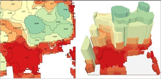
The Partial Map “Vegetation Heights” contains all vegetation areas in the State of Berlin indicating their mean vegetation height (Figure 1).
Basic data was collected in two aerial photography flight phases; one in early autumn 2010 covering the city centre and parts of the southern city area and the other in late summer 2009 covering the outskirts of the city. Thus, the green volume data was collected already 6 or 7 years prior to its analysis.
Due to changes in land use (e.g. by covering agricultural and fallow areas) or vegetation type (e.g. by succession of vegetation-free fallows that developed into meadows, shrubbery and trees) and the creation of new parks (such as the facilities at Gleisdreieck), the values stated here may have considerably changed in the meantime. In order to study individual cases, current aerial imagery is available for reference in the Geoportal Berlin. Furthermore, some errors due to methodology occurred in the vegetation data of the outskirts (e.g. of Grunewald and Spandauer Forst).
Both content-related and topological errors had to be rectified in the vegetation data before transferring the same to the ISU5 areas.
- Topological errors, such as multiple vertices, areas overlapping with themselves as well as overlaps within and between data sets.
- Vegetation areas with a height of 0 were generally assigned a height of 10 cm (corresponding to lawns, low-growing roof greening).
Rather than creating a 3D canopy model, a simple cylinder graph was used (Figure 1). As a result, the green volume has mostly been somewhat overestimated.