The Teltow and Barnim flat uplands are usually characterized by depths to groundwater greater than 10 m. Confined groundwater often occurs here. Groundwater here was not reachable for vegetation previously either.
Current depths to groundwater in the deeper-lying areas of the Warsaw-Berlin Pleistocene Watercourse are often less than 4 m. Exceptions include the areas near well galleries, and the highpoints of the Müggelberge and Gosener Berge (hills), which are a morphological island in the glacial valley. Groundwater only appears here in depths of greater than 10 m (some more than 40 m). Groundwater levels in the pleistocene watercourse were generally higher previously. The lowering of groundwater by public waterwork withdrawals has strongly influenced local conditions for vegetation (cf. Map 02.11).
Low depths to groundwater are found along the glacial meltwater channel which runs from the Barnim into the pleistocene watercourse. These valley sections, in which the Tegeler Fliess and the Mühlenfliess, as well as the Panke and the Wuhle (creeks) flow today, sometimes stretch deeply into the Barnim. The depth to groundwater in this area is usually under 2 m, and some localized depths of < 1.0 m can be found. The Tegeler Fliess, important because of its relatively large area, has very low depths to groundwater. Withdrawals made from the Tegel Waterwork are noticeable here, too.
Low depths to groundwater are also found in the Spreetal (valley) between Dämeritzsee and Seddinsee (Gosen Meadows).
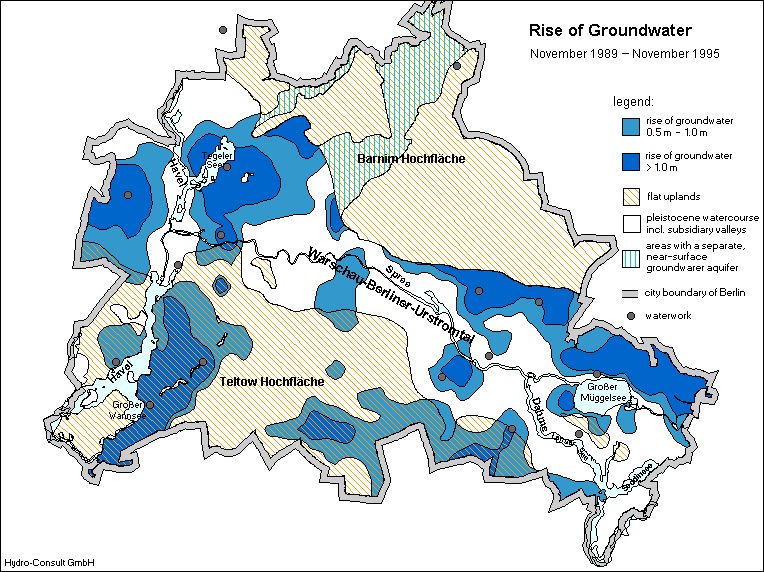
The dimensions of the groundwater rise in Berlin since 1989 are clearly shown on the Figure 4. Here the rise of groundwater levels from November 1989 to November 1995 is illustrated. Groundwater rise of > 0.5 m can be found in broad areas of the pleitocene watercourse, which anyway has low depths to groundwater. The rise of groundwater especially in the closer catchment areas of waterworks is very significant. Due to the decreasing levels of withdrawals in these areas, the groundwater levels have risen between 1 m and 3 m. The results of the groundwater rise in the flat upland areas are not so important because there the depths to groundwater are generally higher. In those areas of the Teltow flat upland, where confined groundwater occurs, the depicted rise of groundwater refers only to the groundwater pressure area. Depths to groundwater in such areas remain unchanged.