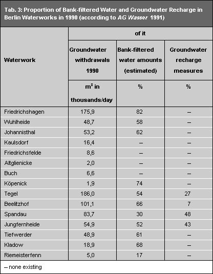
Unused groundwater may be fed into surface waters. Unused groundwater from the Barnim and Teltow flat uplands flows into the Berlin Pleistocene watercourse. It flows as groundwater parallel to the Spree, and as surface water in the Spree, in the direction of the Havel. It may also be used as bank-filtered water, or for groundwater recharge at the Jungfernheide waterworks.
The strong effect of groundwater withdrawals on groundwater divides is reflected especially by the groundwater catchment area of the Rupenhorn and Schildhorn galleries, as well as the catchment area of the north and south galleries of the Tiefwerder waterworks. The catchment areas extend not only to the east (where the galleries are), but also to the west of the Havel. The galleries withdraw groundwater that was percolated through the sewage farms of Karolinenhöhe. The groundwater dynamic shows an undercurrent of the Havel in the areas of these galleries (Leibenath 1990). The groundwater from both sides of the Havel would flow into this area under natural conditions.
A reversal of natural flow directions because of anthropogenic intervention has also occurred around other galleries which withdraw groundwater as bank-filtered water (the galleries at Müggelsee, Langen See, both sides of Tegel lake, and the Havel). Groundwater does not flow towards the surface waters, but rather away from them. It flows towards the galleries.
The map shows on the whole that the entire city can be seen as a catchment area for the Berlin waterworks. Most of the catchment areas extend beyond the city limits into the state of Brandenburg.

