Building and Vegetation Heights 2012

Map Description

For the first time, Berlin has a record of the “vertical extent” of the city which is largely very precise. In project Phase 1, an area of approx. 445 sq km, covering the entire inner city and also a large part of the southern half of the city, has been assessed. In project Phase 2, the assessment of the rest of the cities area and of the surrounding area of Berlin amounting to a total of 1,800 sq km, was also assessed. Especially with regard to vegetation, there is now a new and very suitable information base for many types of utilization.

Based on the ALK building outlines and their storey lines, amine height has been provided for each building portion. Mean height values are also provided for the vegetational items.

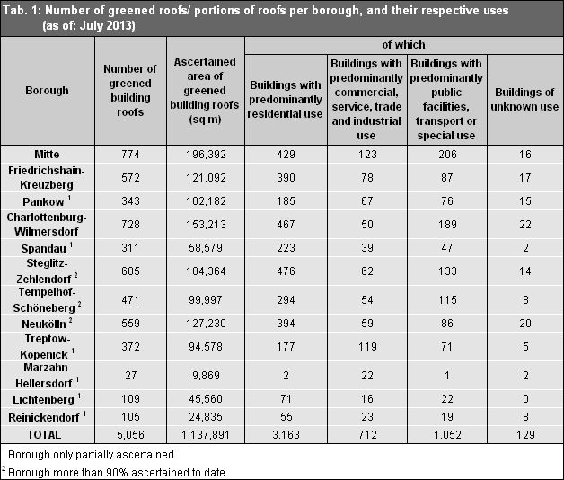
For the first time, roofs with a green component have been ascertained in this context, albeit, due to the data quality, they have been published only for the inner city area examined the Project Phase 1. In the context of the project, some 5,000 buildings with roofs which have been partially or completely greened have been “initially ascertained” with sufficient precision. Upon conclusion of the determination of the remaining areas of the city currently being processed, a complete overview of the city will be available. Table 1 gives an overview of the state of ascertainment of the area of Project Phase 1 (the inner city and the southern half of the city), broken down by borough.

Tab. 1: Number of greened roofs/ portions of roofs per borough, and their respective uses (area ascertained shown in red, as of: July 2013); the ascertainment of green roofs in the rest of the city did not provide sufficient data quality to permit an assessment.

Tab. 1: Number of greened roofs/ portions of roofs per borough, and their respective uses (area ascertained shown in red, as of: July 2013); the ascertainment of green roofs in the rest of the city did not provide sufficient data quality to permit an assessment.

By bringing together both the built-up and green shares, the areas with various green segments in the urban area are very well recognizable. It is noticeable that even in the inner city, not all areas are densely built-up or impervious. Rather, in the old neighbourhoods dating back to the Imperial era, for instance to the north and south of the former Görlitz Station (now a park), there is not only a high share of trees, but rather a significant amount of green space is recognizable in private and semi-public areas, often with very old stands of trees. Here, it is clear that at least in those parts of the inner city built after 1918, residentially oriented open spaces were accorded very great significance (cf. Figure 19).

This effect is even more obvious in residential estates in which an open design interspersed with gardens was used. Figure 20 shows this effect clearly in two areas at the edge of the inner city, the Neu-Tempelhof estate, and the row-house construction with landscape residential greenery along An der Wuhlheide in the borough of Treptow-Köpenick.

Fig. 19: Classification results in the Berlin inner city: Highly impervious inner-city buildings on both sides of Friedrichstraße (left), and Imperial era block construction with a high share of green space in the area of “Görlitz Park (right) (scale 1: 7500)

Fig. 20: Classification results in the area of loose, intensively green construction at the edge of the inner city (inside the Circle Line): Row-houses and duplexes with gardens in Neu-Tempelhof (left) and row-houses with landscaped residential greenery south of An der Wuhlheide in Treptow-Köpenick (right) (scale 1: 7500)

The structure, including the vertical structure, within parks, such as the Great Tiergarten, the green space around Gleisdreieck, or the Görlitz Station Park is very impressively visible, thanks to the classification system selected; the share of the area covered by lawns can be clearly distinguished from the higher standing vegetation and from the trees. This is also true in forests and forest-like stands of trees.