For the evaluation of the soil functions the characteristic soil values (cf. 01.06) derived from the Soil Association Map (Map 01.01) and the associated dissertation by Grenzius (1987) were largely used. The quality of these basic data decisively determines the quality and informational value of the evaluation of the soil functions. From this and other information criteria were derived (cf. 01.11) which permitted an initial evaluation of the soil functions (according to Lahmeyer 2000). The method of valuation was developed within the context of work on a soil protection concept, and used exemplarily for a part of Berlin (Lahmeyer 2000). Later, the method was transferred to the whole city and the now-existing maps were drafted. (Gerstenberg / Smettan 2001)
The Environmental Atlas maps are available in the new Map Application
Soil Functions 1990
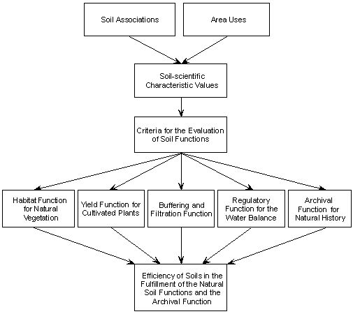
Figure 1: Plan for the evaluation of soil functions
Image: Umweltatlas Berlin
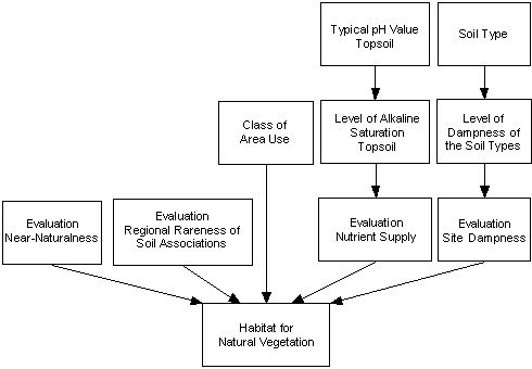
Figure 1: Plan for the evaluation of the habitat function for natural vegetation
Image: Umweltatlas Berlin
Evaluation of the soil function Habitat for natural vegetation from the evaluation of Near-Naturalness, broken down into special and other sites
Image: Lahmeyer 2000
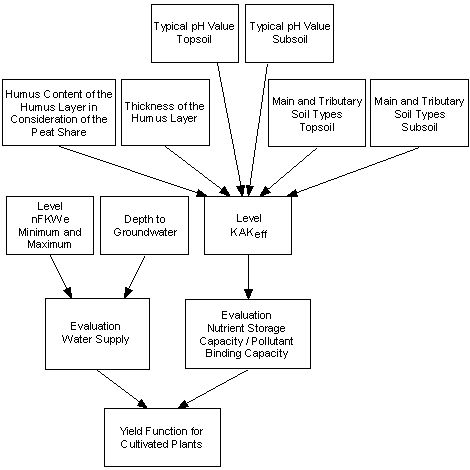
Figure 1: Plan for the evaluation of the yield function for cultivated plants
Image: Umweltatlas Berlin
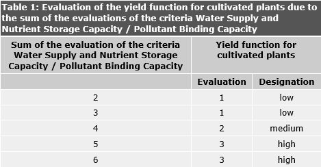
Table 1: Evaluation of the yield function for cultivated plants due to the sum of the evaluations of the criteria Water Supply and Nutrient Storage Capacity / Pollutant Binding Capacity
Image: Lahmeyer 2000 and Gerstenberg / Smettan, 2001

Figure 1: Scheme for the evaluation of the buffering and filtration function
Image: Umweltatlas Berlin
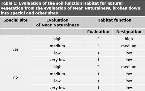
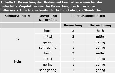
Table 1: Evaluation of the soil function Habitat for natural vegetation from the evaluation of Near-Naturalness, broken down into special and other sites
Image: Lahmeyer 2000
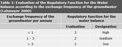
Table 1: Evaluation of the Regulatory Function for the Water Balance according to the exchange frequency of the groundwater
Image: Lahmeyer 2000
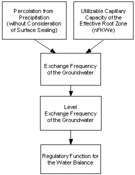
Figure 1: Plan for the evaluation of the Regulatory Function for the Water Balance
Image: Umweltatlas Berlin
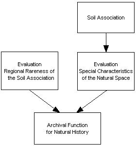
Figure 1: Plan for the evaluation of the archival function for natural history
Image: Umweltatlas Berlin
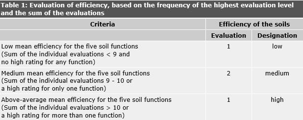
Table 1: Evaluation of efficiency, based on the frequency of the highest evaluation level and the sum of the evaluations
Image: Umweltatlas Berlin
Environmental Atlas Contact
Berlin Senate Department for Urban Development, Building and Housing
Mrs. Haag