Planning Advice for Soil Protection 2001

Methodology

Specific Assessment of Soil Functions

For the solution of these two tasks – a differentiated assessment of soil functions, and implementation of soil-function assessment in the Planning Notes – the following considerations and work steps have been implemented in Map 01.13:

First of all, the soil functions (Maps 01.12.1 through 01.12.5) have been weighted differently, in accordance with their significance to the specific conditions in Berlin (in detail in GERSTENBERG et al., 2007):

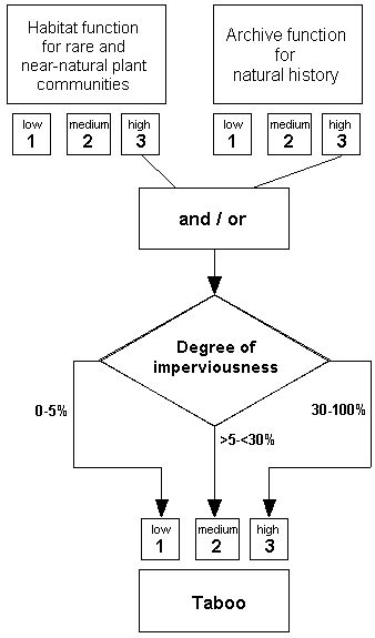
  • Archive soils and soils which constitute sites for rare and near-natural plant communities are classified as deserving of extraordinary protection, due to their non-restorability.
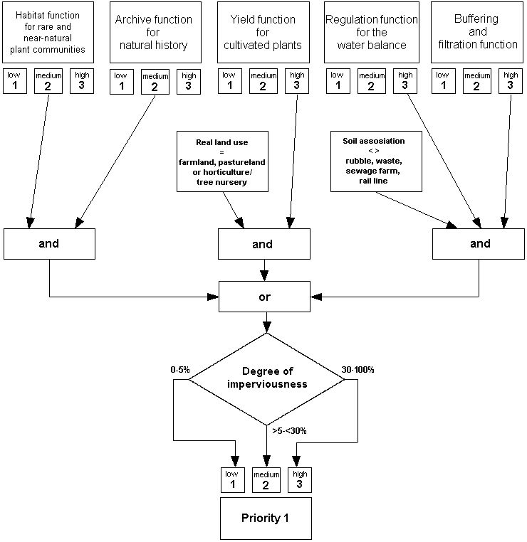
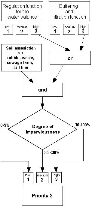
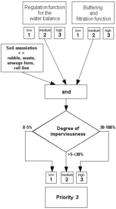
  • Soils which are efficient with respect to the regulation function for the water balance and the buffering and filtration function are deserving of protection generally; the significance rises at these locations still further if these two functions appear together, with a high assessment.
  • Soils which show a high yield function for crops exist in agriculturally used sections.

This establishes a prioritization regarding the significance and sensitivity of soil functions.

Moreover, soils with considerable potentials for material contamination (e.g. sewage farms) are removed from the assessment process regarding the regulation and the filtration and buffering functions, since they represent a possible source of burden for the groundwater.

For the assessment of soils with regard to their protection-worthiness, four protection categories have been established, graduated from the highest to the lowest protection status. They imply consequences for requisite action, and recommendations regarding interventions in the soil due to development plans and construction projects. These four soil protection categories are:

  • Taboo (off-limits sections)
  • Priority 1 (soils deserving exceptional protection)
  • Priority 2 (soils deserving special protection) and
  • Priority 3 (soils deserving protection).

The concept “priority” refers first of all to the discipline of soil protection, and should not be confused with the prioritization used in spatial planning, which involves the weighing of conflicting interests. Since the object of examination is the entire area of the State of Berlin, the concept “priority” is designed to certify the significance of a section within the context of Berlin from the aspect of soil protection.

The non-certified areas of the city belong to the “non-relevant area.”

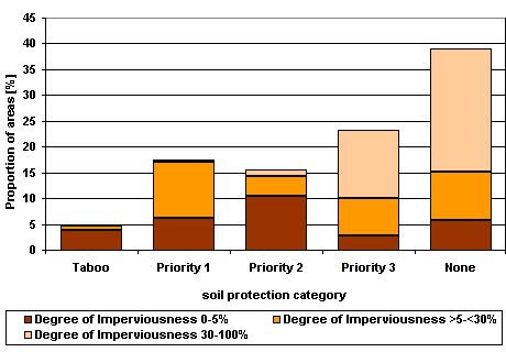
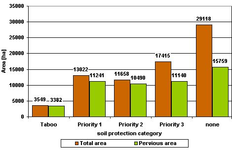
As in the case of all Environmental Atlas maps on the topic Soil, except the Imperviousness map, the information and assessments shown here refer to the pervious portion of the soil. However, since the extent of imperviousness is of great importance, the degree of imperviousness is not shown only in the display of factual data, but also in the coloring of sections by protection category: these are shown in three degrees of intensity, decreasing with the increasing degree of imperviousness.

The imperviousness levels 5 % and 30 % have been chosen here as the boundaries between the three categories of intensity shown by this shading: with imperviousness of 5 % or less, a section can be considered completely pervious, interrupted only by scattered buildings, pathways or the like; this includes forests, fields and pastureland. Allotment gardens, single-family homes, parks and other open areas, which may also have near-natural soils, dominate in the medium-level category. Imperviousness greater than 30 % occurs primarily in residential and commercial sections, and in transportation areas, which for the most part have no natural soil associations at all any more.

Taboo (Off-limits Areas)

The “taboo areas” are thus certified on the basis of their high assessments as providing “habitat functions for rare and near-natural plant communities “ and/or for their “archive function for natural history.”

This category shows the highest protection status, and covers only approx. 5 % of the area evaluated. The category is described as an Off-Limits Area in respect to possible planning, since the habitat function for rare and near-natural plant species is virtually unrecoverable, and the archive function for natural history is definitely unrecoverable (SMETTAN & LITZ 2006). Therefore, projects or plans which involve intervention in the soil can definitely not be authorized for reasons of soil protection.

The term “taboo” has no legal status, in planning law or otherwise, but is designed to underscore the special significance of these sections from the technical aspect of soil protection.

Figure 1: Chart for assignment to the protection category "taboo"

Figure 1: Chart for assignment to the protection category "taboo"

Priority 1 (Soils Deserving Exceptional Protection)

The category Priority 1 may be based on any of several assessment factors:

  1. The “habitat function for rare and near-natural plant communities” and likewise the “archive function for natural history” are of medium importance, or
  2. the yield function for crops is high, or
  3. the “regulation function for the water balance” and/or the “buffering and filtration function” are high.

The majority of the sections in this protection category have been assigned to it due to their habitat and archive functions, a smaller number due to their regulatory or buffering and filtration functions, and only a few sections because of their yield function for crops.

The area category “Priority 1” means that interventions should be avoided as a matter of priority, for reasons of soil protection.

Figure 2: Chart for assignment to the protection category "Priority 1"

Figure 2: Chart for assignment to the protection category "Priority 1"

Priority 2 (Soils Deserving Special Protection)

The category Priority 2 is based on a high assessment for the “regulation function for the water balance” or for the “buffering and filtration function.

The lower protection status compared with Priority 1 is due to the considerably lower number of soil functions involved. It is sufficient that only one criterion (either the regulation function for the water balance or the buffering and filtration function) be assessed as high.

Figure 3: Chart for assignment to the protection category "Priority 2"

Figure 3: Chart for assignment to the protection category "Priority 2"

Priority 3 (Soils Deserving Protection)

The category Priority 3 is based on a medium-level assessments for the “regulation function for the water balance” and simultaneously for the “buffering and filtration function.

This class, with the weakest protection category, covers the greatest share of area of any protection category (cf. Fig. 5).

Figure 4: Chart for assignment to the protection category "Priority 3"

Figure 4: Chart for assignment to the protection category "Priority 3"

Non-Relevant Areas (Soils with No Special Requirements)

The remaining soils (29,118 ha) are grouped in a category of their own, “soils with no special soil protection requirements.”

For non-relevant areas, the general legal soil protection requirements (FEDERAL SOIL PROTECTION LAW 1998, FEDERAL SOIL PROTECTION AND RESIDUAL WASTE ORDINANCE 1999, BERLIN SOIL PROTECTION LAW 2004, BUILDING CODE 2004) apply.

Figure 5: Area shares of soil protection categories by imperviousness class (percentages, without roads and waters)

Figure 5: Area shares of soil protection categories by imperviousness class (percentages, without roads and waters)

Figure 6: Total area and pervious area of soil-protection categories

Figure 6: Total area and pervious area of soil-protection categories

Figure 7: Area shares of use classes per soil-protection category

Figure 7: Area shares of use classes per soil-protection category

Notes for Implementation in Planning Practice

From the soil-protection aspect, the planning notes are relevant requirements and stipulations for the relevant categories of soil protection. They refer to the level of development planning, but can be substantively transferred analogously to another spatially relevant plans or projects. For methodological reasons, the representation is shown in the map only in very general form in the legend. Detailed information is available in the display of factual data for each section for the map via the FIS Broker, in tabular form. The terms used, such as “avoidance,” “compensation,” or “inadmissibility,” should not be seen as legal categories, but rather represent technical soil protection stipulations. In this connection, it should be recalled that the weighted soil functions refer exclusively to the pervious segments of the blocks.

The factual data display shows the soil protection category, the soil association and land use upon which the assessment is based, the assessment of the five individual soil functions (from Map 01.12) as well as the degree of imperviousness. The planning requirements table, which can also be shown for each section separately, is of special interest, however.

Structure and contents of the planning requirements table:

Line 1 states the soil protection category and indicates the degree of protection-worthiness from the soil-protection aspect.

Line 2 represents the reasons for the classification (cf. “Methodology Item 1”) into shortened form. The statements in the additional lines justify themselves respectively by these value giving soil functions.

Line 3 states the general soil protection goal.

Line 4 evaluates development plans to be drafted or changed, from the soil protection aspect.

Line 5 shows in detail the fundamentally desirable avoidance and reduction steps. No distinction has been made between avoidance and reduction, since assignment in the context provided will be decided differently, depending on point of view of the actor. The key goal is the prevention of interventions in the soils deserving protection, not the precise language of the terminology.

Line 6 gives suggestions for compensation, as function-related as possible. Accordingly, such requirements are stated which can conditionally be imposed as per the stipulations of the Building Code.

Line 7 contains in some cases additional measures which would be useful from the soil-protection aspect to compensate for considerable impairments of soil functions.

Line 8 contains other notes and explanations.