An essential problem in the definition of climatically based aims and methods exists therein, that concrete limits and index values for the appraisal cannot be drawn from one of the regulations comparable to the Technical Instruction Air (i.e. TA-Luft). The commission “Reinhaltung der Luft” (Air Purity) of the Union of German Engineers (VDI) and the German Institute for Standardization (DIN) is working of course on a guideline for establishing of climate and air hygiene maps also for urban spaces. However, their release is to be expected in 1994 at the earliest.
It was thus necessary to define particular criteria and goals for the map of climate functions. The guidelines of the German Meteorological Society (DMG, 1989) prescribe a crude framework in that they strive for as ideal state of affairs a city climate which is largely free from pollutants and offers city-dwellers the largest possible diversity of atmosphere conditions under avoidance of extremes.
Basis for the available climate function maps (e.g. City manager of the City of Münster 1992, Neighborhood Association Stuttgart 1992, Local Government Association Ruhrgebiet (KVR) 1992) is the determination of the so-called climatope, spatial units, which are defined essentially through the elements relief and use and assumed to be relatively homogeneous in their microclimate. The synthetic climate function map for the Ruhr area, Dortmund part of the KVR defines for the urban area the following climate types: villa, outskirts, city, inner city, city center, industry and small business. The way they are recorded for large spaces makes it relatively easy to generate interpretations of heat pictures of the surface temperatures, topographical maps and land use inventory. On the basis of these climatopes climatic function areas are delimited and planning references compiled.
In the present map an attempt is made, which relies more essentially on the measurements of climate parameters and also further criteria, such as the area, location in the city and/or surrounding countryside as well as considers the mutual interactions among the sections. Thus the same terrain in the inner city load area would be judged differently than if it were situated on the outskirts of town. That is because the influential factors to which the area is subject and/or the influence, which the area exercises on others can be very different. In case of an appraisal based only upon structure types, it would only be concerned an uniform appraisal in both cases (e.g. Type “villa climate”).
The delimited function spaces should be able to deliver statements as to which areas where
- on one hand a potential for the relief of other (adjacent and also further remote) spaces is available (areas of 1a and 1b) and
- on the other hand beyond the wide-area effects, the strongest addition loads are to be expected (areas of 4a and 4b).
Between these two poles, spaces were defined,
- in which the climatic conditions are favorable, i.e. no climatic load exists (relieved area 2)
- those in which their structures and functions present transitions between burdened and relieved areas (area 3).
Besides areas were to be marked, which to be assumed as preferred air exchange areas, i.e. which play an important role for the near ground fresh air transport.
For these climatic function areas the sensitivity was estimated against use intensifications. This sensitivity was rated as high, if an use intensification made probable a new classification as a more unfavorable function area. By use intensification is understood an increase in the built-up share as opposed to the undeveloped area. “This includes the transformation of the natural ground surface into a three-dimensional modeled space consisting predominantly of artificial materials, the reduction with it of vegetation covered surface as well as the influence through technical arrangements that cause waste heat and pollutant emissions” (Kuttler 1993).
The most important equalization effects issue from the relief areas. A low mean temperature as well as high cooling rates in the evening and night hours are made possible by their slight degree of sealing (< 20 %) and high vegetation share, so that these areas function as cold air generators. The wind and exchange relationships over open areas during the day can be considered as very good. However in tree stocked parks and especially in forests, they worsen rapidly. Above all, high pollution risks emerge occasionally at night, dependent on the proportion of open areas, through the stabilization of the near ground air layer, causing a significant decrease in the climatic equalization potential of these areas. This is especially true in the vicinity of emitters.
All open spaces were defined as climatic relief areas 1a, which lie within the load areas 4a/4b or border directly on these. The areas stand spatially in direct cover overbuilt areas and present in their function as cold air origin areas an essential potential for the relief of these equalization spaces. The extent to which this potential affects any single area can only be clarified through detailed investigations. Beside the area size and -geometry, the area’s edge structures and/or the surrounding development are most important. According to v. Stülpnagel (1987) an area of approx. 10 ha can be taken as orientation measure for a larger outside effect. This assumes however, that also smaller areas at suitable local conditions can perceive equalization functions.
The extreme sensitivity toward development and sealing applies to the surfaces in area 1a. They are on the contrary in need of continuous maintenance, i.e. above all through avoidance of any pollutant emissions within these areas.
Area 1b can be found on the outskirts of town and in the open spaces of the surrounding countryside. They do not of course lie in direct proximity to the load areas. However due to their extensive area they exercise likewise an important relief function. Here a high sensitivity exists toward use-intensifying measures. It is especially their extensive area and the fact that these areas reach well into the outskirts of the city which gives them their decisive importance.
These areas are to be distinguished from built-up areas, which profit of course from the relief function the 1b areas, however through their development and degree of sealing which leads to average higher temperatures and slighter cooling rates than the relief areas themselves. Due to the still favorable climatic structure, the relieved area (area 2) offers the greatest potential for structural consolidation of all function spaces. According to current knowledge a cautious consolidation of these areas would result in no new classification as a climatically more unfavorable area. In which orders individually the boundaries for a structural condensation lie, can not be indicated all-inclusive; in each trap the possibilities are to be examined at the place itself, to compensate with measures like roof or facade greening negative climatic effects.
The climatic transition area (area 3) includes areas of very heterogeneous uses with different degrees of sealing and vegetation shares; accordingly the climate parameters differ between the values of the area 2 and the load area of 4a.
In the Map of Urban Climate Zones (Map 4.05, SenStadtUm 1993e) corresponds to the transition area in wide parts of the climate zone 3. That means moderate urban climatic change. In the areas direct nearby and with it direct interaction with relieved (area 2) or loaded (areas of 4a/4b) city spaces exists a high sensitivity facing use-intensifying actions, since at a structural condensation a climatically unfavorable consequence on this interaction function is to be expected. The exact delimitation of the sensitivity areas presupposes however broader investigations.
Load areas are those with a high degree of sealing (> 60 %) and over-construction (chiefly > 50 %), in which high mean temperatures, a slight cooling in the evening and night hours as well as a high humidity risk have been recorded. The in part, bad wind and exchange relationships lead locally to high pollution loads (cf. Map 04.03, SenStadtUm 1994).
The load area in areas are divided according to the intensity of climatically negative changes into high sensitivity toward use-intensifying actions (area 4a) and areas with very high sensitivity and urgent necessity for the implementation of suitable rehabilitation measures (area 4b). Here all open spaces are, even the smallest, are to be maintained.
The local and/or regional wind systems which produce air exchange between green and built-up areas (plain wind effect) and/or the surrounding countryside and the inner city cannot as a rule be registered without costly, targeted measurements in the terrain or model tests. In this map areas are shown on one hand, as preferred because of their structure for the near ground fresh air transport depicted and/or are to be examined for this purpose. Criteria for their appropriateness are above all a slight roughness of the surface, a sufficient width (as more as possible as the 10-fold amount of the surrounding edge structures) as well as predominantly low pollution load (Kuttler 1993, Mayer and Matzarakis 1992). Good airstream channels thus become formed e.g. through broad courses of the river, path lines and green areas with lower vegetation. On the other hand a small scale air exchange between equalization and load spaces for open spaces within or in direct proximity to the areas of 4a and 4b is presented. Here plain wind currents are primarily to be expected because of the large temperature gradient to the overheated neighboring developments during low exchange radiation weather conditions. The range of the relief effects or the existence of possible exchange obstacles can be ascertained however only through more exact investigations in the vicinity or experiments.
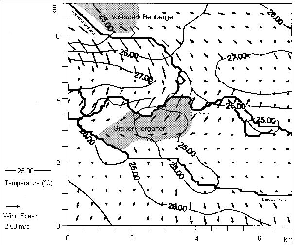
The first investigations into plain wind effects for Berlin were produced by the model study meanwhile supported by the BMFT “Project Effect of Regional Climate Changes in Urban Conurbations Using the Example of Berlin” (Wagner 1993). Here temperature and currents were simulated for a 7 × 7 km2 inner city area on the basis of different land use parameters. Figure 1 shows a summer simulation, which was run using the marginal values typical for this season: In the green spaces of Tiergarten and Volkspark Rehberge the temperatures lie clearly lower than in the heated greatly sealed areas. In the area of the green spaces an acceleration in the current is indicated, while currents decelerate in the heavily built-up areas because of the friction. The increased air exchange proceeding with it is significant for the air hygiene situation in Berlin.