Vegetation Heights 2020

Methodology

Approach

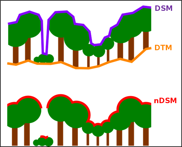
The process for determining the vegetation height is based on a complex workflow, which is presented here only as a rough overview. Please refer to the project report (only in German) for more details regarding each step.

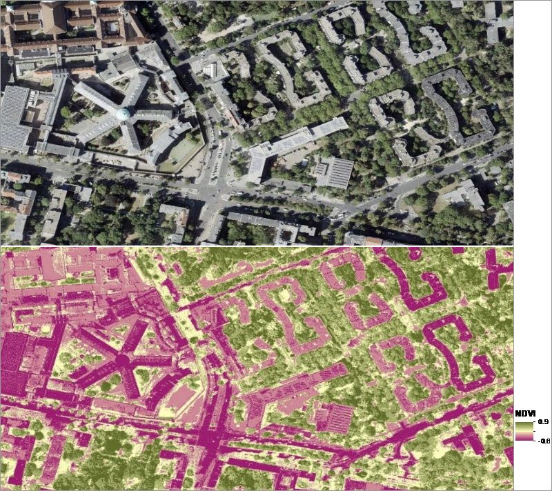
When updating the dataset to the version of 2020, the entire procedure was switched from object-based sectioning (aerial photography flights in 2009/ 2010) to grid-based sectioning. This is, first and foremost, advantageous with regard to the size and completeness of the dataset and therefore its suitability for further processing. Using this method, the 2010 dataset could also be reclassified and recalculated. The two periods could therefore be compared without methodological discrepancies while also minimising potential errors. As mentioned above, the calculations of the 2010 dataset were based on image-based digital surface models from aerial photography flights in 2009 and 2010. This document, however, only indicates the year 2010 as the reference year for the mapping. This is the case as the colour-infrared orthophotos from aerial photography flights in 2010 form the main source for the vegetation index calculations.

Data Processing (DSM)

Before vegetation heights may be recorded, information on heights needs to be derived from the true orthophotos in a digital surface model first. The processing of the image-based Digital Surface Model (iDSM) is based on stereo photography. Orientation parameters are used to link the individual, generously overlapping, aerial photographs together via tie points. They are then joined together to form a cohesive image and transferred to the required coordinate system at the same time (Kraus 2004).

The iDSM provides coded elevations of the earth’s surface including all objects located on it (buildings, roads, vegetation, etc.). This is achieved by adding the terrain elevation to the height of the object. Berlin’s terrain elevation is inconsistent, despite rather small differences in topography (ranging from ~35 m to ~100 m above sea level). The absolute height of an object may therefore not be established reliably at this point. A normalised digital surface model (nDSM) is required for this, i.e. the terrain needs to be set to zero for the entire model. An nDSM is thus generated by subtracting the Digital Terrain Model (DTM) from the digital surface model (DSM):

  • nDSM = DSM – DTM

With regard to the subsequent classification, this simplifies the distinction between elevated and non-elevated objects and ensures the direct measurement of object heights. It permits the differentiation of roads, elevated vegetation and buildings and provides precise information on heights (cf. Figure 3).

Fig. 3: Principle for generating a normalised Digital Surface Model (nDSM)

Fig. 3: Principle for generating a normalised Digital Surface Model (nDSM)

Calculation of the NDVI

The Normalised Difference Vegetation Index (NDVI) may be calculated based on the generated true orthophotos. Using the characteristic reflective properties of plants in the spectrum of red and near-infrared wavelengths, this index may be used to identify the density and intensity of vegetation in a grid-based dataset. The NDVI is calculated from the quotient of the difference and the sum of the near-infrared channel (NIR) and the visible red channel ® (Rouse et al. 1974):

  • NDVI = (NIR – R) / (NIR + R)

The NDVI ranges from -1 to 1. The higher the value, the higher the amount of green vegetation present (cf. Figure 4).

Fig. 4: top: 2020 true orthophoto, bottom: NDVI, normalised vegetation index, on the left: JVA Moabit (former prison facility)

Fig. 4: top: 2020 true orthophoto, bottom: NDVI, normalised vegetation index, on the left: JVA Moabit (former prison facility)

Development of the Vegetation Inventory

Supervised classification of CIR-True-Orthophotos

The true orthophotos from 2020 were classified to delineate areas with vegetation from those without. For this purpose, training areas were manually sorted into land cover categories on screen and thus digitised. The classification contained the following categories: “areas without vegetation”, “low-growing vegetation” and “high vegetation”. Due to the prolonged summer drought in 2020, large areas with low-growing vegetation (predominantly meadows) withered. The additional category of “low-growing vegetation, withered” was therefore included.

Based on these training areas, a supervised classification of the entire mosaic could be carried out using a machine learning algorithm (RandomForest, cf. Breiman 2001).

Establishing a rule base and deriving vegetation heights for 2010 and 2020

Five smaller sample areas were selected to further develop the process (cf. Figure 5). These sample areas met the following criteria:
  • distributed across the urban area with varying urban and vegetation structures:
    • heterogeneous inner-city location,
    • forest area,
    • transition from forest to residential area,
    • transition from forest area to body of water,
    • agricultural structure on the periphery,
  • deviating topography.

Fig. 5: Location of the sample areas used for method development, background: true orthophotos from 2020

A rule base for differentiating 5 classes that distinguish between different types of changes that have occurred since 2010 was established with the help of the sample areas to prevent errors as much as possible during the analysis phase. This was necessary as the true orthophotos of the 2009 and 2010 aerial photography flights were not available. The existing data could therefore not be reclassified directly. Digital orthophotos (DOP) from 2010 and the nDSM from 2010 were used instead, as well as vegetation sections from the 2010 mapping.

The rule base defines queries regarding the vegetation sections from the 2010 mapping, the NDVI in 2010 and 2020, any ALK or ALKIS and OSM buildings at the relevant times, as well as the normalised surface height (see the project report for more details, only in German).

Following these rules, the following 5 classes are created, forming the grid of thematic changes:
  • Class 1: Vegetation sections are missing mistakenly in 2010, vegetation is still present in 2020,
  • Class 2: Vegetation is present in 2010 and 2020,
  • Class 3: Vegetation is present in 2010 but not in 2020,
  • Class 4: Vegetation is present in 2020, no vegetation in 2010,
  • Class 5: Vegetation sections are missing mistakenly in 2010, no vegetation in 2020.

Using the grid of thematic changes, vegetation heights were derived from the respective nDSM at a grid resolution of 1 × 1 m² for both 2010 and 2020.

Calculation of vegetation heights and shares at block (segment) area and road level

For all block (segment) areas and road sections of the 2020 ISU5, a zonal analysis (zonal statistics) was carried out to calculate the mean, maximum, minimum and median of the vegetation heights based on the two vegetation height grids. Furthermore, the vegetated area within a block (segment) area (in percent) was determined for both years.

The data display in the FIS Broker includes the following information on the block (segment) area or road area that has been selected:

Tab. 1: Attribute label and factual data display of the 2020 Vegetation Heights dataset

  • Attribute label

    Description

  • ANTEIL_OEFF_BAUM2020

    Area share (%) of the road section that contains trees from the tree register

  • ANTEIL_VEG_2010

    Area share (%) covered with vegetation (2010)

  • ANTEIL_VEG_2020

    Area share (%) covered with vegetation (2020)

  • change_anteil

    Change in the above shares between 2010 and 2020 (2010 minus 2020)

  • MAX_OEFF_BAUM2020

    Maximum height (m) of trees in the tree register within a road section (2020)

  • MAX_VEGH_BL2010

    Maximum height (m) of vegetation (2010)

  • MAX_VEGH_BL2020

    Maximum height (m) of vegetation (2020)

  • MEAN_OEFF_BAUM2020

    Average height (m) of trees in the tree register within a road section (2020)

  • MEAN_VEGH_BL2010

    Average height (m) of vegetation (2010)

  • MEAN_VEGH_BL2020

    Average height (m) of vegetation (2020)

  • MED_VEGH_BL2010

    Median height (m) of vegetation (2010)

  • MED_VEGH_BL2020

    Median height (m) of vegetation (2020)

  • MIN_VEGH_BL2010

    Minimum height (m) of vegetation (2010)

  • MIN_VEGH_BL2020

    Minimum height (m) of vegetation (2020)