The analysis of the stock of green space covered all green spaces in the area of the city with recreational potential.
In addition, the Britz Garden, the Marzahn Recreational Park, and facilities of the Foundation for the Prussian Palaces and Gardens in Berlin and in Brandenburg, the Charlottenburg Palace grounds and Glienicke Park have been included. The Botanical Garden and the two Zoos have not been included in the availability analysis.
The Britz Garden in Neukölln and the Recreational Park in Marzahn are two exceptional cases in the evaluation. Both green spaces have limited accessibility due to the fact that an entry fee is charged; moreover, they are not under the responsibility of the green space agencies. Due to their important recreational functions and the relatively low amount of their entry fees, they have nonetheless been assigned to the category of unrestrictedly usable green space.
The Berlin forest areas have been included, so as to ascertain the residential blocks in the intake areas near the forests and the edges of the forests.
The following criteria were used for the assessment:
-
Area size
Open spaces for near-residential recreation must have a minimum size of 0.5 ha, to make type-specific use possible. For green spaces bisected by streets, the resulting segments are considered only if one of them is larger than 0.5 ha. However, smaller areas can also be included, provided that they border on green facilities directly, and are thus located in the context of the green network structure.
Moreover, it is assumed that green facilities which are greater than 10 ha and are assigned to the “Near-Development” category are needed and visited by residents living nearby, in the manner of near-residential use. Therefore, for the purposes of this analysis, these larger facilities have also been assigned intake areas, and calculated accordingly. -
Accessibility
Unhindered accessibility to the open space must be guaranteed. Obstacles include railway lines, large bodies of water, and motorways.
The classification of heavily-traveled streets with more than 15,000 motor vehicles/day as obstacles, and hence as barriers, has been changed since the 2009 Edition. The barrier effect of heavily traveled urban streets is now assessed as less limiting to recreational use, since the possibility of crossing at traffic lights is now evaluated as sufficient to assure accessibility.
Ascertainment of Intake Areas
Based on the map of Dedicated Public Green and Recreational Facilities (Senate Department for Urban Development I C 2, as of Dec. 31, 2011), all green spaces found to be usable were assigned an intake area (green facilities in adjacent areas in the state of Brandenburg were not taken into account).The intake areas were determined by means of a circle drawn automatically around the respective open space, with the distance determined as the crow flies. To compensate for the difference between this distance and the actual distance to the green space, approx. 10% was subtracted from the maximum distance. Thus, a radius of 450 m resulted for near-residential open spaces. Only complete blocs with residential use were used in the calculation.
For smaller facilities, the centre was chosen as the point of origin of the radius; for larger spaces, the entrance area was used (approx. 100 m inside the open space). The intake area calculated for near-residential green space, for a distance of between 300 and 500 m around that green space, took only complete blocks and block segments into account.
Since the accessibility of a green space can be reduced by psychological or physical barriers, these were addressed next. Barriers include e.g. rivers and canals, railroad lines, airports and motorways. If such barriers exist around a green space, the intake area was corrected.
Wooded areas were also assigned an intake area. It was assumed that the edges of forests can to some extent assume the functions of a near-residential open space. Forest edges were evaluated so highly as recreational areas that throughout Berlin, blocks in an intake area of 500 m from forest areas were categorized as having green space available.
The same was done in some cases even for well-structured farmland areas, or other high-quality open spaces (e.g., Gatow, Großglienicker Weg or Krugpfuhl Blankenfelde); these were likewise categorized as provided with green space, and were assigned an intake area.
Recreational use of agricultural areas is possible only to a limited degree, and only in some parts of the area; however, in the Berlin portion of the Barnim region, the areas accessible by footpath were included in the assessment. For this developing near-urban recreational area, the agricultural segments of the planned park landscape are important.
Calculation of the Degree of Availability
According to the standard value applicable in Berlin, the availability of public green spaces to the population at a level of 6 sq m or more of near-residential open space per inhabitant is considered sufficient. As a result of the ascertainment of the sq m of green space per inhabitant in a defined intake area, the degree of availability of public green space per inhabitant is obtained. Based on this value, the degree of availability (sq m of green space/inh) was broken down into four levels. The categories are, first, Areas of availability, where near-residential green space is available at a level of more than 6 sq m/inh. (Category 1: Availability provided); Areas of non-availability, which have no useful green space (less than 0.1 sq m/inh., Category 4: Availability not provided); Areas of insufficient availability, including all residential areas with a degree of availability between 0.1 and 5.9 sq m/inh. Availability of less than 50 % of the standard value, i.e. less than 3 sq m/inh., is shown separately (Category 2: < 6.0 sq m/inh.- 3.0 sq m: Availability poorly provided; Category 3: < 3.0 – 0.1 sq m/inh.: Availability minimally provided).
For the calculation of the respective degree of availability, the number of inhabitants in the intake area of a green space was divided by the size (the calculated population by the sq m of green space).
For the block and segment-based calculation of the availability of green space, all blocks were included in which more than 10 inhabitants/ha live. This so-called population threshold was established for the planning process to ensure theat the automated analysis also considered the population of areas with structure types with predominantly commercial, services, trades and industry, and those with “other uses”, without however including building supervisors (caretakers) or security personel in purely industrial areas. This established planning value has been halved since the 2009 Edition, from 20 inhabitants to 10. In this way, more inhabited blocks could be included, especially in inner-city locations with key metropolitan use types, or mixed-use areas (see Figure 2).
Provision with Private Green Space
The map with the matrix of the degree of availability of public green space was superimposed on a map of the building structure of residential areas, and thus provides further insight into the availability situation. It shows the relationship between public and private availability of open space.
In order to ascertain not only the availability of public green areas to the population, but also that of private green space, the urban structure recorded in the Environmental Atlas was divided into three structure types with different proportions of private open space (see the gradations high – medium -low in the legend). Examples of these respective types include single-family home areas, row-house neighbourhoods, and the imperial-era residential blocks of the inner city.
Deduction of the Housing Type
The building structure can be examined as an indicator for the available share of private open space. Areas with different building structures, but with comparable shares of private/semi-public open spaces, were lumped together, and classified into three categories (cf. Fig. 1):
-
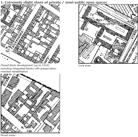
Extremely slight share of private/ semi-public open spaces
This involves predominantly areas of closed-block development (up to 1914), including all preservation-oriented reconstructed blocks integrated into this building structure. In addition, core and mixed areas are counted in this category. -
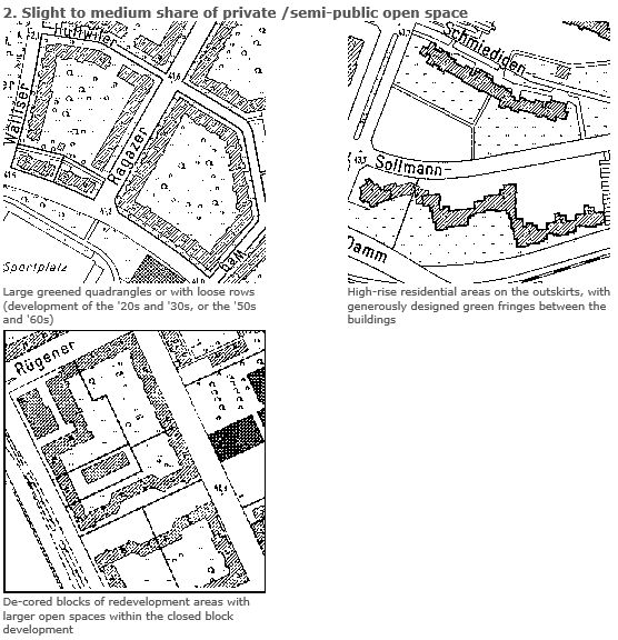
Slight to medium share of private/ semi-public open spaces
To this category belong all building structures which display large quadrangles or strips of green space (development from the ’20s and ’30s and/or from the ’50s and ’60s), and the high-rise apartment developments on the outskirts of town with generous green spaces (green separators) between the buildings. Furthermore, the redeveloped apartment blocks also include closed block development which was decored completely, and thus has larger open spaces. The compact, high-rise developments of the ’90s are also included here. -
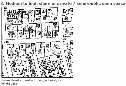
Medium to high share of private/ semi-public open spaces
This category includes all open development (for instance single-family or row-house development), and also the low density single-family housing developments of the ’90s. to a large extent, the buildings have their own gardens, so that the share of private green space is very high.