Criteria for the Evaluation of the Soil Functions 2005

Methodology

01.11.1 Regional Rareness of Soil Associations

Description

In order to preserve great site variety, the goal is to safeguard the existence of as many different soil types as possible.

The criterion “rareness” was used to describe the spatial distribution of soil associations in the State of Berlin. Soils occur with varying frequency in the Berlin area. With the aid of the Soil Association Map, a survey of the distribution and hence the rareness or frequency of soil associations can be provided.

The less the relative area share of a soil association is, the more endangered it is, i.e., with the level of endangerment increases with the inverse of the area share.

The evaluation of rareness refers exclusively to soil associations and not to single soil types. Thus, rare soil types may occur in less rare or even relatively frequent soil associations, and vice versa.

Statistical Base

The data base for the determination of regional rareness is the Soil Association Map.

Methodology

The determination of the spatial shares of the single soil associations was carried out in reference to the land sections by means of the data available in the City and Environment Information System. Areas covered by roadways and bodies of water were not taken into account. The section sizes were summed up for each soil association, and compared with the total area observed. The result includes values for area shares of the respective soil associations as percentages of the total area.

The procedure represented by Stasch, Stahr and Sydow (1991) was selected for the evaluation of the rarity of soils. The evaluation was carried out according to the spatial occurrence of soil associations in Berlin.

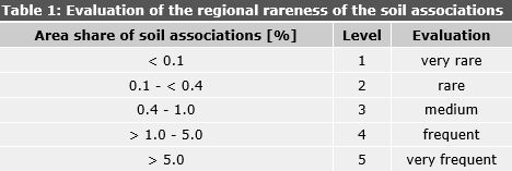
The rarity of the soils was classified in five categories from “very rare” to “very frequent” (Tab. 1). The combined associations (cf. Map 01.01) were assessed as belonging to their component soil association with the lowest spatial distribution. The conceptual soil association2471 [49a] was classified in category “frequent”, like soil association 2470 [49].

Tab. 1: Evaluation of the regional rareness of the soil associations

Tab. 1: Evaluation of the regional rareness of the soil associations

01.11.2 Special Characteristics of the Natural Space

Description

The Ice-Age accretions have given the natural space of the Berlin area special characteristics considerably different from those of other landscapes in Germany. Particularly striking features include such geomorphological peculiarities as dead-ice kettles, end and push moraines, dunes and former glacial-stream channels.

Dead-ice kettles resulted from blocks of ice remaining from the last Ice Age which melted away later and which today appear as round, sometimes water-filled depressions featuring groundwater-influenced soils and mire associations. Loamy soils with sandy wedges in which dry fissures were filled with blown drifting sand during the late Ice Age are located on undisturbed glacial-till plateaus, and are recognizable in an aerial view as a regular polygonal network.

End and push moraines are accretion moraines which formed at the edges of the ice when there was a balance between melt-off and fresh ice. They appear in the landscape today as ridges and hills.

Late and post-glacial dunes are still clearly recognizable from their shapes, but hardly move anymore, due to their covering of vegetation.

The glacial stream channels have in many cases survived, and form chains of lakes and wetlands. The soil developments and the soil associations which occur are closely connected with the morphology and the source materials present, and reflect special characteristics and peculiarities of the natural space here.

Methodology

Only those soil associations have been considered which are associated with unusual Ice-Age-related geomorphologically features, and which have been able to develop undisturbed from the Ice-Age accretions. Soils with a special peculiarity may be only little anthropogenically affected; therefore, only near-natural soil associations were considered (cf. legend to Map 01.01). Soils consisting of land-fills and dumps, or rearranged soil material, have received no identification of natural spatial peculiarity. A compilation of soil associations which represent special characteristics of the natural space, due to their source material, their special morphology and their largely undisturbed soil development, is shown in Table 1. These are primarily moraine plateaus with sand wedges, moraine hills, glacial stream channels with groundwater soils and mires, flood-plains with alluvial soils, gyttjas and peats, and dunes.

The soil associations listed in the Table 1 receive a positive evaluation with regard to their natural-spatial peculiarity. All other soil associations do not show any particular natural-spatial peculiarity.

Tab. 1: Soil associations with a special natural-spatial peculiarity

Tab. 1: Soil associations with a special natural-spatial peculiarity

01.11.3 Near-Natural Quality

Description

In the Berlin city area, soils have been subjected to great anthropogenic changes. The criterion “near-naturalness” describes the extent of the changes vis-à-vis the original natural situation. Changes in this connection include particularly intermixing of the natural horizons of the soils, the removal of soil material, or the overburdening with outside materials. Substance immission and lowering of the groundwater table are not considered here. With the aid of the Soil Association Map and information on land use, it is possible to provide an overview of the extent of anthropogenic change, and hence of the near-naturalness of the soils and soil associations in Berlin.

This criterion has special significance, inasmuch as it can be assumed that natural soil characteristics and the variety of soil qualities have primarily been preserved at little-changed sites, whereas anthropogenic influence has led to a homogenization of soil types and qualities. Therefore, the rough distinction between near-natural and anthropogenically characterized soil associations has already been undertaken in the formation of the legend units of the Soil Association Map.

Methodology

For the determination of the near-naturalness, Blume, Sukopp (1976) introduced the term “hemerobic levels” for soils, analogous to the term hemerobia in botany. Accordingly, various land-use forms were classed in so-called hemerobic levels, according to the degree of cultural effect on ecosystems. Grenzius used this system in 1987 to describe the anthropogenic influence on soils and soil associations in the Map of Soil Associations of Berlin (West), 1985.

Grenzius further subdivided the hemerobic levels, depending on land use (cf. Tab.1). The point of departure was that particularly the specific anthropogenic uses of sections determine the type and size of the change and destruction of their natural soil.

The classification of the sections is shown in Table 1 according to use, by various authors.

Tab. 1: Evaluation of the Near-Naturalness based on Hemerobics

Tab. 1: Evaluation of the Near-Naturalness based on Hemerobics

Since no completely unchanged soils exist in Berlin anymore, the categories of unchanged or little-changed soils were not considered. Accordingly, the categories were newly established, with consideration for the classification criteria of Blume, Grenzius and Stasch, Stahr, Sydow, repectively, for the evaluation of Berlin soils.

For the determination of the near-naturalness of the soils, data for soil associations, use, use type and sealing degree were used. From these values, an automated classification was carried out as an initial aggregation step, by assignment of certain combinations of soil associations, uses and sealing degrees to the corresponding evaluation categories with regard to near-naturalness (levels 1-10 in Grenzius, according to Tab. 1), including use type if appropriate.

For selected land uses, such as green areas and parks, fallow areas etc., an individual evaluation of near-naturalness was required. Soils in park and green areas and of fallow areas can have been changed to very different degrees. While soils in inner-city areas have as a rule changed considerably, or even been completely newly formed by land-filling, etc., in the outlying areas, near-natural soils can often be found, which have the same use, but have undergone only minor changes. The near-naturalness of these sections was therefore determined individually with the aid of topographical maps, protected-area maps and reports.

For the presentation in this map, an evaluation and summary in four levels, from “very low” to “high”, was used (cf. Tab. 2, according to Lahmeyer 2000).

Tab. 2: Evaluation of Near-Naturalness, Based on Levels

Tab. 2: Evaluation of Near-Naturalness, Based on Levels

01.11.4 Exchange Frequency of the Soil Water

Description

The exchange frequency of the soil water indicates how quickly the water in the animate soil zone is replaced by incoming precipitation water. The lower the exchange frequency, the longer the dwell time of the water in the soil. Longer dwell times have a compensating effect on the groundwater flow rate, and permit a better reduction of certain immitted substances.

Methodology

The exchange frequency of the soil water has been calculated as a relationship (quotient) between the percolation (in mm per annum, long-time mean values) and the utilizable capillary capacity of the effective root space (mm).

The percolation was calculated with the help of the ABIMO runoff formation model of the Federal Institute of Hydrology, as the difference between precipitation and evaporation. This model incorporates surface-section-specific data on precipitation, land use, vegetation structure, capillary capacities (from the soil types), and depth to water table (i.e., from the surface) (Glugla et al 1999) (cf. Map 02.13.4)

For the determination of the percolation in connection with the evaluation of soil functions, the effect of sealing has not been considered here, i.e. the calculation was carried out under the assumption of completely unsealed conditions. In the proximity of sealed soils, exchange frequencies increase considerably again, due to runoff precipitation water.

The utilizable capillary capacity of the effective root space was derived from the Soil Association Map, and the land uses by means of the schematic soil profiles of soil associations in Grenzius (1987).

Since the exchange frequency of the soil water is ascertained only seldom, there are no general evaluation standard. The values ascertained in Berlin were therefore evaluated in such a way that each level covers a similarly large share of the city’s area.

Tab. 1: Levels of the exchange frequency of the soil water

Tab. 1: Levels of the exchange frequency of the soil water

01.11.6 Nutrient Storage Capacity/ Pollutant Binding Capacity

Description

The storage and binding capacity describes the ability of a soil to bind nutrients or pollutants to the organic substance or to the clay minerals of the soil. It depends on the clay content, the type of clay minerals and the humus content. Organic material in the form of humus or peat has a considerably higher binding capacity than do clay minerals. This is dependent on the pH value, however, and drops with the pH value. Soils with high clay contents and a high proportion of organic substance, with weakly acidic to neutral pH values, therefore have a high binding capacity for nutrients and pollutants.

Methodology

The nutrient storage capacity/ pollutant binding capacity of the soils is derived from the levels of the ascertained effective cation exchange capacity (cf. Map 01.06.9), which is very largely reflected by the above-mentioned characteristic values.

The evaluation of the binding capacity is carried out in three steps, according to Table 1, from the levels of effective cation exchange capacity, where levels 1 and 2 are combined as low, and levels 4 and 5 are combined as high.

Tab. 1: Evaluation of the Nutrient Storage Capacity/ Pollutant Binding Capacity, Based on the Levels of Mean Effective Cation Exchange Capacity (KAKeff)

Tab. 1: Evaluation of the Nutrient Storage Capacity/ Pollutant Binding Capacity, Based on the Levels of Mean Effective Cation Exchange Capacity (KAKeff)

01.11.7 Nutrient Supply

Description

The nutrient supply for a site is determined by the stock of nutrients and from the nutrients available to plants. The nutrient stock consists of the minerals in the parent rock, which are released when the soil weathers. The nutrients currently available as basic cations of calcium (Ca), magnesium (Mg), potassium (K) and sodium (Na) in the soil solution can be derived from sum of interchangeable cations. (S-Value) (cf. map 01.06.08).

This only permits statements on the total set of basic cations, not information on the relationship of the mutual interrelationship of various cations. Thus, e.g., a site may have good nutrient supply in terms of calcium and magnesium, yet have a potassium deficit.

The nutrients phosphorus (P) and nitrogen (N), which could be approximately ascertained from the content of organic substances in the soil, were not taken into account here – only the share of alkaline cations.

Methodology

For a rough statement on the current nutrient supply of the soil associations, the layers of sum of interchangable cations of topsoil were used for the evaluation (cf. Map 01.06.8).

The simplified evaluation of the nutrient supply by means of alkaline saturation is accomplished as in Table1: Level 1 to 6 are nutrient-poor, level 7 is Medium and level 8 to 10 are Rich nutrient.

Tab. 1: Evaluation of the Nutrient Supply, from sum of interchangeable cations

Tab. 1: Evaluation of the Nutrient Supply, from sum of interchangeable cations

01.11.8 Water Supply

Description

Water supply of plants depends on capacity of soil to store precipitated water in root zone and capability of sending this water again to plant root. Quantity of water which soil can hold depends on the type of soil, humus, storage thickness and share of coarse soil. Ground water in contact with soil climbs by capillary action and plays vital role in water supply of plants.

Evaluation of soil with respect to water supply depends on average utilizable capillary capacity of flate root zone.

Methodology

Water supply of locations and soil assosiations is derived from medium utalizable capillary capacity (nFk) of flate root zone ( 3 dm) (cf. map. 01.06.02), this criteria is only for evaluation of yield function of cultivated plants ( cf. 01.12.2), and of living space function of near natural and seldom plant association ( cf. 01.12.1). Water supply for deep root plants for example trees are not considered here. Evaluation is given in table. 1. By increasing ground water depth to < 0,8 m evaluation of capillary capacity will become one level higher. (If its not already high).

Tab. 1: Level of utilizable capillary capacity and evaluation of water supply

Tab. 1: Level of utilizable capillary capacity and evaluation of water supply

01.11.9 Filtration Capacities

Description

The filtration capacity of a soil indicates its capacity to bind dissolved and suspended substances in the soil and not let them reach the groundwater. The decisive factor is the type of soil and the resulting speed with which precipitation water moves through it by the force of gravity. Therefore the filtration capacity of gravelly and sandy soils with high water permeability is low, since the water moves more than two meters per day in water-saturated soil, while for soils consisting of boulder clay, the speed of movement amounts to only 0.1 to 0.2 meters per day.

However, how much water – if any – actually moves toward the groundwater (depending on evaporation/ vegetation) has not been taken into account in the evaluation of Filtration Capacity. This has been partly taken into account under the criterion Exchange Frequency of the Soil Water (cf. Map 01.11.4).

Methodology

The filtration capacity of the soils is ascertained on the basis of the water permeability (kf value) (cf. Map 01.06.10). The thickness of the filtration path up to the groundwater is not considered under this method.

The evaluation is carried out in three categories, based on Table 1. Soils with high water permeability, with kf levels 4-6, are assigned a low filtration capacity, and less permeable soils, with kf levels 1-2, are assigned a high capacity.

Tab. 1: Evaluation of Filtration Capacity, Based on the Levels of Water Permeability

Tab. 1: Evaluation of Filtration Capacity, Based on the Levels of Water Permeability

01.11.10 Binding Power for Heavy Metals

Description

The binding of heavy metals is accomplished by means of the adsorption of humins, clay minerals and sesquioxides. The solubility of heavy metals is dependent on their total content, and on the pH value of the soil solution. The solubility of heavy-metal compounds generally increases with increasing acidification. This is connected with the fact that the metals tend to form stable oxides at higher pH values, or to enter into not easily dissoluble compounds, e.g. PbCaCO3, through precipitation.

Relative binding power of heavy metals is used as one critiera for Filter and Buffer function.

Some of heavy metals are bind quite differently (DNWK 1988). Cadmium relatively dissolve quickly and spread as background load in Berlin.That’s why recommended method from Hamburg Senate department of Health and Environment (2003) power of binding of easily dissolved cadmium would be used as binding power for heavy metal.

Methodology

Blumen and Brümmer (1987-1991) found a concept to judge the sensitivity against metal load that is now used for allover Berlin. Principle of Progonosis is that relative binding power of some metal dependens on Ph value of soluble soil solution, based on condition of sand soil with week binding power and poorly humus Higher humus, clay and ironhydroxide enhances binding power and vice versa.The calculation is valid till 1 m depth. So here stepwise evalution for topsoil and subsoil dependent on ph value of humus and clay contents was determined, that’s how it gives the sum of binding power BSSM. This value could be further corrected by coarse soil , horizontal depth and this value could be between 0 to 5, nothing to very high binding power for heavy metal

Tab. 1: Evaluation of the Relative Binding Power of Heavy Metals in Dependence on pH Value Humus and Clay Contents, Coarse Soil and Horizontal Depth

Tab. 1: Evaluation of the Relative Binding Power of Heavy Metals in Dependence on pH Value Humus and Clay Contents, Coarse Soil and Horizontal Depth