As a rule, population density increases from the city edge to the city center. In the city center itself, however, only up to 70 p/ha are found in most blocks. Factors for this are the large open areas of the Tiergarten park and the Zoo, trade and service centers, and the large number of construction sites. Leipziger Strasse (street) and the new residence units on Wilhelmstrasse are densely populated and are conspicuous exceptions to general conditions in the city center.
The Wilhelminische Ring stands out with a “predominately high population density of 351 and more p/ha”. The area has a block structure from the late 19th-century and is located within and on the edge of the City Rail Circle line. There are peak values of 793-796 p/ha in the Neukölln, Kreuzberg and Charlottenburg boroughs. Outside the City Rail Circle line, the relatively high population density continues south into the Schöneberg, Friedenau, and Steglitz boroughs. Population distribution similar to that within the inner City Rail Circle line is found in older development areas of Spandau, and is similar to other areas such as Tegel, Schöneweide, Adlershof, and Tempelhof. When these areas were developed around the turn of the century, they were on the edge of Berlin. They were later incorporated into Berlin.
The high-rise and industrially-prefabricated settlements at the edge of the city are relatively densely populated with 151 to more than 550 p/ha in large block areas. These are Märkisches Viertel, Hohenschönhausen, Marzahn, Hellersdorf, and Gropiusstadt.
Small settlements with post-war high-rise development fall predominately in the 151 to 250 p/ha range. These areas at the edge of the city in Spandau, Lichterfelde, Marienfelde, Waidmannslust, Bohnsdorf, and Köpenick are relatively less densely populated. Some locations in this population density class are settlements with block-edge and row development. Examples are Haselhorst, Siemensstadt, Zehlendorf, and Plänterwald.
Typical for the city edge, and the most numerous, are relatively thinly populated settlements with 5 – 150 p/ha. These blocks are block-edge or row development, 71 – 150 p/ha; low developments with yards, 5 – 70 p/ha; and villa developments with park-like gardens and some semi-private re-greening, 31 – 70 p/ha. The eastern edge of Berlin is generally less densely settled than the western edge.
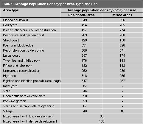
The distribution of population density correlates quite clearly with Environmental Atlas Map 06.07, “Urban Structure”. It is apparent that area types can be assigned a certain range of population density. Table 1 gives average population densities for residential area types. These calculations are based only on areas of uniform use, not on blocks of heterogenous use.

