The pre-2001 inner-city boroughs of Wedding, Tiergarten, Mitte (all now in the borough of Mitte), Prenzlauer Berg, Friedrichshain, Kreuzberg (the latter two now combined) and Schöneberg,as well as parts of Neukölln and Wilmersdorf, the Westend area of Charlottenburg and the old town of Spandau are connected to the combined sewerage system.
The outlying former boroughs of Köpenick, Neukölln, Tempelhof, Reinickendorf, most of Spandau (the latter both still single boroughs), Pankow, Weissensee (now combined), Hohenschönhausen, Lichtenberg (now combined), Marzahn, Hellersdorf (now combined), and parts of Wilmersdorf and Charlottenburg (now combined), are connected to the separate sewerage system.
In Berlin, the prevalent type of separate sewerage system is that of rainwater drainage plus a sewerage system. Areas with this type of system are mainly found in closer proximity to the inner city areas, in the new boroughs of Spandau, Reinickendorf, Pankow, Lichtenberg, Marzahn-Hellersdorf, Treptow-Köpenick, Neukölln, Tempelhof-Schöneberg and Steglitz-Zehlendorf, as well as some south-western sections of Wilmersdorf-Charlottenburg, a small area in the north-eastern part of Mitte, and the Stralau peninsula in the south-eastern section of Friedrichshain.
There are a few small residential areas with rainwater drainage with no sewerage system in the eastern parts of the city, in the Blankenburg and Karow neighbourhoods.
To reduce the load on the combined sewerage system in some areas of Wilmersdorf to the north of the municipal motorway, rainwater sewers were built which discharge into the rain overflow drains of the combined sewerage system. Sewage continues to pass through these combined sewers. This is also true of central Spandau, Weissensee and some areas of Charlottenburg along Schloßstraße, north of Bismarckstraße.
Areas with existing sewerage systems but percolation of rainwater can be found at the outskirts in Gatow, Spandau, Konradshöhe, Heiligensee, Frohnau and also sporadic in other parts of the periphery. There are still some old settlement areas without sewerage systems. Some of these areas like Mahlsdorf Nord IV, Buchholz West II, Altsiedlung Blankenburg, Stadtrandsiedlung Blankenfelde, Altsiedlung Heinersdorf, Buchholz Nord II, Siedlung Spreetal und Siedlung Wartenberg will being connected to the sewerage systems depending on the costs for local public infrastructure and issues of urban development (planned realisation period 2009 up to 2015) (Berlin Waterworks 2012b). The development activities are in progress in all these areas, and some sections have already been completed.
02.09.2 Catchment Areas of Rainwater Drainage
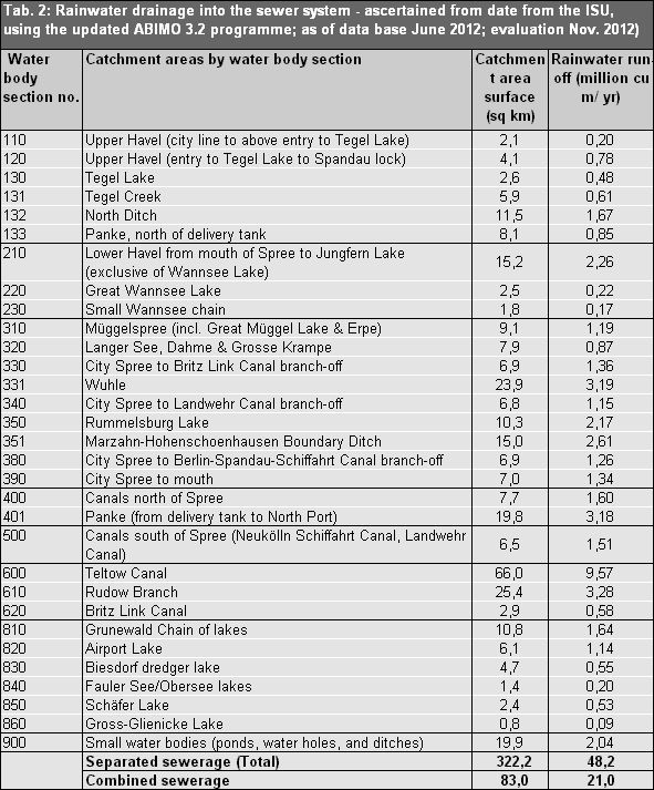
Depending on the main receiving water body, the catchment areas of rainwater sewers are found in the intake areas of the Spree and Dahme rivers in the eastern and southeastern sections of Berlin, of the Havel river in the northern, northwestern and southwestern parts of Berlin, and of the Teltow Canal in southern Berlin.
Lakes, park lakes, ponds and other blind drainage water bodies are spread over the entire area of the city.
Since within the inner S-Bahn Circle Line, the combined system prevails, and this area for the most part has no separate sewerage, it has not been assigned to any rainwater drainage catchment area. The only exceptions are Tempelhof Airport and parts of Wilmersdorf to the north of the motorway, which drain into the canals south of the Spree (the Neukölln Schifffahrts Canal and the Landwehr Canal).


