Strategic Noise Maps 2017

Calculation Results / Tabular Evaluations

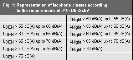
As required in the “Directive on the Assessment and Management of Environmental Noise”, strategic noise maps graphically represent the noise situation in the following isophone classes:

Fig. 1: Representation of isophone classes according to the requirements of the "Directive on the Assessment and Management of Environmental Noise"

Fig. 1: Representation of isophone classes according to the requirements of the "Directive on the Assessment and Management of Environmental Noise"

They form the basis for preparing an overall urban noise reduction plan (only in German).

The noise exposure is specified through the following variables:

  • Tabular data about the estimated number of persons living in areas located within the isophone bands according to Figure 1. Figures should be rounded up or down to the next hundredth place.
  • Tabular data about noise-exposed areas as well as the estimated number of dwellings, schools and hospitals in these areas for the following LDEN values: LDEN > 55 dB(A), LDEN > 65 dB(A), LDEN > 75 dB(A). Figures of impacted dwellings should be rounded up or down to the next hundredth place here.

The summarized results of the exposure and area statistics for the main federal railway lines for conurbation areas are available here.

Road Traffic

Note: The current strategic noise maps required a change in the detailing of the statistical parameters used, including the building uses and the inhabitant distribution across block segment areas. Therefore, the impact statistics of the 2012 and 2017 Berlin noise maps cannot be compared directly to each other.

Table 4: Number of people impacted in their homes due to road traffic noise on all streets assessed (based on the noise index LDEN)

Table 4: Number of people impacted in their homes due to road traffic noise on all streets assessed (based on the noise index LDEN)

Table 5: Number of people impacted in their homes due to road traffic noise on all streets assessed (based on the noise index LNight)

Table 5: Number of people impacted in their homes due to road traffic noise on all streets assessed (based on the noise index LNight)

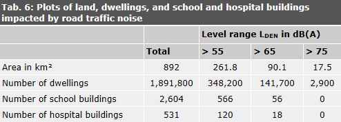
Table 6: Plots of land, dwellings, and school and hospital buildings impacted by road traffic noise on all streets assessed

Table 6: Plots of land, dwellings, and school and hospital buildings impacted by road traffic noise on all streets assessed

In the assessment of schools and hospitals affected, each building of the respective facility was considered.

Streetcar and Subway Traffic

Note: The current strategic noise maps required a change in the detailing of the statistical parameters used, including the building uses and the inhabitant distribution across block segment areas. Therefore, the impact statistics of the 2012 and 2017 Berlin noise maps cannot be compared directly to each other.

Table 7: Number of people impacted in their homes due to streetcar and subway noise (based on the noise index LDEN)

Table 7: Number of people impacted in their homes due to streetcar and subway noise (based on the noise index LDEN)

Table 8: Number of people impacted in their homes due to streetcar and subway noise (based on the noise index LNight)

Table 8: Number of people impacted in their homes due to streetcar and subway noise (based on the noise index LNight)

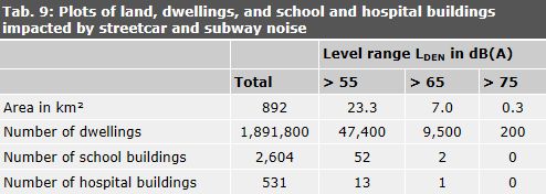
Table 9: Plots of land, dwellings, and school and hospital buildings impacted by streetcar and subway noise

Table 9: Plots of land, dwellings, and school and hospital buildings impacted by streetcar and subway noise

In the assessment of schools and hospitals affected, each building of the respective facility was considered.

Industry and Commerce

Table 10: Number of people impacted in their homes due to industrial and commercial noise (based on the noise index LDEN)

Table 10: Number of people impacted in their homes due to industrial and commercial noise (based on the noise index LDEN)

Table 11: Number of people impacted in their homes due to industrial and commercial noise (based on the noise index LNight)

Table 11: Number of people impacted in their homes due to industrial and commercial noise (based on the noise index LNight)

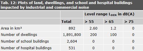
Table 12: Plots of land, dwellings, and school and hospital buildings impacted by industrial and commercial noise

Table 12: Plots of land, dwellings, and school and hospital buildings impacted by industrial and commercial noise

All individual buildings were included in the evaluation of the schools and hospitals involved.

Air Traffic

Note: The current strategic noise maps required a change in the detailing of the statistical parameters used, including the building uses and the inhabitant distribution across block segment areas. Therefore, the impact statistics of the 2012 and 2017 Berlin noise maps cannot be compared directly to each other. However, this effect is of minor importance when it comes to air traffic, as mixed use only occurs in a limited part of the impacted areas.

Berlin-Tegel Airport, reference year 2015

Table 13: Number of people impacted in their homes due to aircraft noise from Berlin-Tegel Airport (2015) (based on the noise index LDEN).

Table 13: Number of people impacted in their homes due to aircraft noise from Berlin-Tegel Airport (2015) (based on the noise index LDEN).

Table 14: Number of people impacted in their homes due to aircraft noise from Berlin-Tegel Airport (2015) (based on the noise index LNight).

Table 14: Number of people impacted in their homes due to aircraft noise from Berlin-Tegel Airport (2015) (based on the noise index LNight).

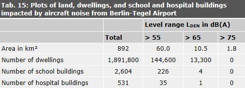
Table 15: Plots of land, dwellings, and school and hospital buildings impacted by aircraft noise from Berlin-Tegel Airport

Table 15: Plots of land, dwellings, and school and hospital buildings impacted by aircraft noise from Berlin-Tegel Airport

Schönefeld Airport, reference year 2010

Table 16: Number of people in Berlin impacted in their homes due to aircraft noise from Schönefeld Airport (2010) (based on the noise index LDEN)

Table 16: Number of people in Berlin impacted in their homes due to aircraft noise from Schönefeld Airport (2010) (based on the noise index LDEN)

Table 17: Number of people in Berlin impacted in their homes due to aircraft noise from Schönefeld Airport (2010) (based on the noise index LNight)

Table 17: Number of people in Berlin impacted in their homes due to aircraft noise from Schönefeld Airport (2010) (based on the noise index LNight)

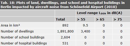
Table 18: Plots of land, dwellings, and school and hospital buildings in Berlin impacted by aircraft noise from Schönefeld Airport (2010)

Table 18: Plots of land, dwellings, and school and hospital buildings in Berlin impacted by aircraft noise from Schönefeld Airport (2010)

Berlin-Tegel (2015) and Schönefeld Airports (2010)

Table 19: Total number of people in Berlin impacted in their homes due to aircraft noise from Berlin-Tegel (2015) and Schönefeld Airports (2010) (based on the noise index LDEN)

Table 19: Total number of people in Berlin impacted in their homes due to aircraft noise from Berlin-Tegel (2015) and Schönefeld Airports (2010) (based on the noise index LDEN)

Table 20: Total number of people in Berlin impacted in their homes due to aircraft noise from Berlin-Tegel (2015) and Schönefeld Airports (2010) (based on the noise index LNight)

Table 20: Total number of people in Berlin impacted in their homes due to aircraft noise from Berlin-Tegel (2015) and Schönefeld Airports (2010) (based on the noise index LNight)

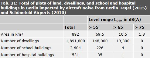
Tab. 21: Total of plots of land, dwellings, and school and hospital buildings in Berlin impacted by aircraft noise from Berlin-Tegel (2015) and Schönefeld Airports (2010)

Tab. 21: Total of plots of land, dwellings, and school and hospital buildings in Berlin impacted by aircraft noise from Berlin-Tegel (2015) and Schönefeld Airports (2010)

All individual buildings were included in the evaluation of the schools and hospitals involved. For example, if school complexes consisted of three buildings, three school buildings were evaluated.