The inventory analysis covered all open spaces listed in the Green Space List, and hence open to the public, with the use type “park and green spaces.”
For the East Berlin boroughs, the probable status of the open spaces first had to be determined, since the major part of the areas listed in the Green Space List, at the time of compilation, were still in the hands of the boroughs, and thus under the legal auspices of the Green Space agencies, although a reorganization and/or change of ownership was to be expected for many areas.
Areas which, according to estimation of the Green Space agencies, would remain under their jurisdiction, and would in addition retain their public character, were classified as public. The basis for this estimation was, as a rule, preliminary consultation between the Conservation and Green Space agencies, the Urban Planning Agency, Public Housing Companies and the Trust Holding Agency (Treuhand) (as of November 1991). The inventory analysis incorporated all parks and city squares, but also areas within those new residential areas generously interspersed with green spaces, for instance, along the so-called “supply corridors” or in the large residential courtyards, provided these constituted an unbroken area of more than 1 ha, and were generally accessible.
The statements regarding probable status of the areas represent the status as of November/December 1991, and are to be reexamined after clarification of ownership and responsibilities.
Appraisal of the Suitability for Recreation
Since near-development green spaces can also fulfill the function of a near-residential open space, the appraisal of the suitability for recreation covered all green spaces over 0.5 ha with regard to the observance of the minimum requirements for near-residential open space examined (cf. Kellermann 1974). The appraisal of the green spaces was based on the existing data and map material.
The following criteria were used for the appraisal:
-
Area size
Open spaces for near-residential recreation must have a minimum size of 0.5 ha, to make the type-specific use possible. For green spaces cut by streets and for which size data for the individual parts is lacking, open spaces are considered only if one of the segments is larger than 0.5 ha. -
Area shape
The open space must be at least in part broader than 15 m. Areas with embankments must have a level space of at least 15 m. -
Accessibility
Unhindered accessibility to the open space must be guaranteed. Green spaces may not be surrounded entirely by obstacles which shut out the intake area. Obstacles include heavily-traveled streets (more than 10,000 motor vehicle/day), rail lines, bodies of water and enclosures (such as at the Kaulsdorfer Busch / water reservoir). The possible existence of pedestrian footbridges and/or tunnels, or of traffic lights, which could mitigate the barrier effect at isolated points, was not considered. -
Ecological damage
Noise pollution and air pollution diminish the recreational value of a period outdoors. Since detailed measurements and/or prepared data in reference to the situation in green spaces were not available at the time of compilation, the pollution factor is here limited to the element of traffic noise.
For green and open spaces, German Industrial Standard (DIN) 18005, 5.87, Sound Protection and Urban Development for Urban Development Planning, specifies a limit of 55 dB (A). With free acoustic propagation, this limit can be reached on a city street with a speed limit of 50 km/h even at a vehicle load of 2,000 motor vehicles per day. Major thoroughfares are as a rule burdened with far more than 10,000 motor vehicles per day. This corresponds to a noise pollution of more than 60 dB (A), and frequently more than 70 dB (A). Intermittent vegetation in green spaces provides no noise buffer. A reduction of the noise can be ascertained solely at increasing distance from the source of the noise. Due to the location of many green spaces on heavily traveled streets, a large number must be considered heavily noise-polluted, and would not therefore be classified as useful for recreation. As a minimum requirement, it was stipulated that at least a part of the open space had to be unaffected by major ecological damage. This criterion was further specified to indicate that an open space on a heavily-traveled street – with a noise level of more than 70 dB (A) – would only be classed as suitable for recreation if it had a minimum depth of 100 m from the street, or a minimum size of 1 ha. Minimum size and/or depth should guarantee that a visit to the open space would be possible at a distance from the street. Green spaces with a size of over 1 ha were thus fundamentally classified as useful.
Minimum requirements with regard to the equipment of open space facilities were not included in the appraisal, since some open spaces examined, especially in East Berlin, are inadequate in terms of equipment. Deficits in this area can be corrected with the appropriation of sufficient funds, however, so that this was not considered a criterion for exclusion.
The Britz Garden in Neukölln und the former horticultural exhibition area in Marzahn constituted two exceptions in the appraisal. Both green spaces are limited in their accessibility by entrance fees, and they do not fall under the responsibility of the Green Space Agencies. Because of their important recreational functions, and the relatively low entrance fees, they were nonetheless classified as fully useful green spaces.
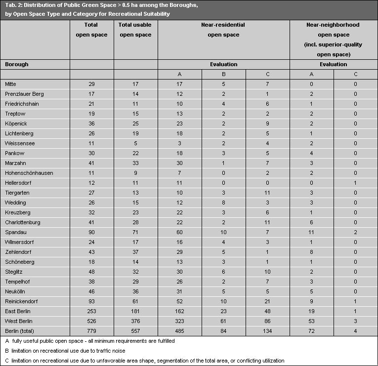
Altogether, 779 public green spaces had a minimum size of 0.5 ha, and were included in the appraisal. Of these, 557 could be classified as fully useful, while 222 green spaces did not meet the standards, 84 of them because of too-high noise pollution levels (cf. Tab. 2).