Environmental Justice Berlin 2021/2022

Analysis results for the entire city and the boroughs

The data analysis is compiled in a comprehensive set of maps and published in the Geoportal as thematic maps. This both involves work on the five-part core indicator approach and the aggregated multiple burden maps that are based on it, which merge the individual topics quantitatively and qualitatively. The three integrated multiple burden maps form the heart of Berlin’s integrated environmental justice monitoring.

The statistical analyses are presented and described below, divided into those relating to the individual core indicators and the multiple burden maps – the entire city and the boroughs – as well as analyses for each individual borough.

Results in a city-wide comparison

Tab. 2. Number of highly burdened planning areas according to the core indicators and status index in Berlin (as of: 2021/ 2022 Monitoring Environmental Justice)

h5. 1) The percentages are related to the absolute number of the 95 planning areas with a low to very low status index.

The correlation of these multiple environmental parameters with the social index indicates their relationship, i.e. the degree of environmental injustice, in Berlin.

Thus, planning areas that are subject to two, three or even four environmental burdens have a significantly higher proportion of low and very low status indices. In contrast, more than 25% of PLA without any environmental burden are characterised by a very high/ high index. If one includes medium indices, too, more than 80% of the affected PLA are covered (see Fig. 6 from SenUMVK 2022).

Fig. 6: Social problem density by number of environmental burdens per planning area (PLA) (as of: 2021/ 2022 Monitoring Environmental Justice)

Fig. 6: Social problem density by number of environmental burdens per planning area (PLA) (as of: 2021/ 2022 Monitoring Environmental Justice)

Cumulating the means of the categories of the 5 core indicators, as well as the categorised population density/ km² and the number of multiple burdens affecting the Berlin boroughs, a distribution emerges that highlights the boroughs within the City Rail Circle Line, i.e. primarily Mitte and Friedrichshain-Kreuzberg, as districts with the highest burdens on average (cf. Figure 7). The summed means of the two boroughs are close together and largely exhibit numbers well above 2 for each indicator.
This means that, generally, the burdens of each of their PLA were categorised as either medium or poor. Mitte is home to 11 of the 19 most polluted planning areas. In Friedrichshain-Kreuzberg, 25 out of 36 planning areas, with a combined 67 percent of the borough’s inhabitants, are facing a twofold or threefold burden; a very high number, compared to the rest of the city.

Fig. 7: Stacked means of the categories of the core indicators, the population density and the number of multiple burdens per borough (as of: 2021/ 2022 Monitoring Environmental Justice)

h5. The categories of the indicators and the population density, summed up by borough, represent the following qualitative ratings:
value 1 = low burden (good situation or high status index), 2 = medium burden, 3 = high burden (poor situation or low/ very low status index);
Population density categories:
value 1 = > 10,000 inhabitants/ km², 2 = 10,000 to < 20,000 inhabitants/ km², 3 = 20,000 and more inhabitants/ km².

Spandau, Steglitz-Zehlendorf and Treptow-Köpenick are the boroughs that are quantitatively least affected by the investigated environmental burdens.

Treptow-Köpenick is the ‘leader’ when it comes to air quality and green space supply. In terms of social burdens, it is also one of the least affected boroughs.

Spandau stands out with an equally very good green space supply. Air pollution and the climate are largely unproblematic, especially in the outer areas of Hakenfelde, Gatow and Kladow.

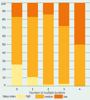
Steglitz-Zehlendorf takes first place in the overall assessment according to Figure 7, i.e. the added means of the individual categories result in the lowest total number. What is particularly striking is the considerably lower number of multiple burdens compared to the rest of Berlin, which indicates a large spread of unburdened or only slightly burdened PLA. Only 4 of the 44 planning areas, clustered around the service area of Schloßstrasse, are subject to twofold burdens. There are no PLA with predominantly simple residential areas, which also makes it a unique borough in Berlin.

For more in-depth information on the boroughs, please refer to the comprehensive report on the updated data and maps of the Berlin Environmental Justice Concept. It presents each of Berlin’s boroughs in a detailed profile (SenUMVK 2022, only in German).

The figures used in the report to compile the borough-specific pie charts are attached as spreadsheets to the data linked to Figure 7 in the Environmental Atlas in the list of Figures and Tables on Environmental Justice 2021/ 2022.