Depth to Groundwater 2002

Introduction

Groundwater levels in a metropolitan area like Berlin are subject not only to natural factors such as precipitation, evaporation and subterranean outflows, but are also strongly influenced by such human factors as development, sealing of surface, drainage plants, withdrawals and recharge.

The main factors of withdrawal include the groundwater demands of public water suppliers, private water production, and the lowering of groundwater levels at construction sites (cf. Map 02.13.15). Groundwater recharge is accomplished by precipitation, shore filtration, artificial recharge with surface water, and return of groundwater at construction sites.

In Berlin, there are two groundwater layers. The deeper layer carries salt water and is largely separated from the upper groundwater layer by an approx. 80 m thick layer of clay, except at occasional fault points in the clay. The upper layer carries fresh water and has an average thickness of 150 m. It is the source of Berlin’s drinking (potable) and process (non-potable) water supplies. It consists of a variable combination of permeable and cohesive loose sediments. Sand and gravel (permeable soils) combine to form the groundwater aquifer, while the clay, silt and organic silt (cohesive soils) constitute a groundwater-obstructing layer.

The groundwater table is dependent on the (usually slight) gradient of groundwater and the terrain morphology (cf. Fig. 1). The depth to groundwater is defined by calculating the perpendicular distance between the upper edge of the surface, and the upper edge of the free, unconfined groundwater table. When the groundwater aquifer is covered by relatively impermeable, cohesive soil layers (a groundwater-obstructing layer), the groundwater is unable to rise enough to reach the height of its hydrostatic pressure. It is under these conditions that the groundwater level becomes confined. Only drilling through the obstructing layer will permit the groundwater at a groundwater measurement site to rise to the level of the groundwater pressure area (Fig. 1). In such a case, the depth to groundwater is defined by calculating the perpendicular distance between the upper edge of the surface and the lower edge of the groundwater-obstructing marl layer which covers the aquifer.

Fig. 1: Terminological Definition of the depth to groundwater at free and unconfined groundwater

Fig. 1: Terminological Definition of the depth to groundwater at free and unconfined groundwater

The Map of Depth to Groundwater gives an overview of the spatial distribution of areas with the same depth classifications, at scale of 1 : 50,000 (SenStadt 2003). It was calculated on basis of the data of May 2002, and applies to the respective near-surface aquifer with an uninterrupted water supply. In Berlin, this in most cases means the main groundwater aquifer (GWL), which is used for water supply (GWL 2, according to the structure of Limberg and Thierbach 2002), and which is uncovered in the glacial spillway, but covered in the more elevated areas. In exceptional cases, the GWL 1 (e.g. in the area of the Panke valley) or the GWL 4 (tertiary formations) were used to determine the groundwater depth.

Areas with a lesser depth to groundwater (to about 4 m) are of particular importance. Pollution of soils can quickly lead to deterioration of groundwater in these areas, depending on the nature of the mantle (permeable or non-permeable) above the groundwater. The Map of Depth to Groundwater is thus a significant basis for the preparation of the Map of the Protective Function of Groundwater Coverage (cf. Map 02.06). The spatial overlaying of groundwater depth onto geological characteristics of the covering mantle permits the delimitation of areas of varying protective functions of groundwater coverage).

Knowledge of groundwater depths enables an estimation of groundwater influence on vegetation. The influence of groundwater on vegetation depends on the root depths of plants and, according to soil type, the capillary climbing capacity of groundwater. The threshold depth at which groundwater can be used by trees is given at 4 m for general Berlin conditions. Vegetation in wetlands depends mostly on the groundwater, and requires a depth to groundwater of less than 50 cm.

The groundwater level in the city is subject to various anthropogenic influences. The first lowering of the groundwater level and the destruction of wetlands in the Berlin area was caused by the drainage of such swampy areas as the Hopfenbruch in Wilmersdorf in the 18th century. The 19th and 20th centuries saw the drainage of other areas due to the construction of canals. The groundwater level was further lowered by the increasing demand for drinking and process water, and by restrictions on groundwater recharging caused by surface sealing, or was subjected to strong periodic fluctuations, with amplitudes of up to 10 meters at a site.

Up until the end of the 19th century, the mean groundwater level in Berlin was subject only to the annual fluctuation in precipitation. The period between 1890 and the end of World War II was marked by rapid urban growth, the construction of rail networks (Alexanderplatz), and by major reconstruction projects. Because of this construction, the groundwater level in the inner city was dramatically lowered, resulting in an 8 m drop in the groundwater level. With the breakdown of the public water supply at the end of the war, the depth of groundwater was able to restore itself to naturally levels (Fig. 2).

Fig. 2: Fluctuation of Groundwater Levels at Measuring Site 5140 in Mitte (Charlottenstrasse) since 1870

Fig. 2: Fluctuation of Groundwater Levels at Measuring Site 5140 in Mitte (Charlottenstrasse) since 1870

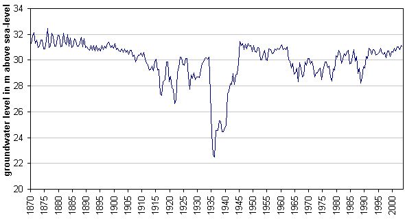
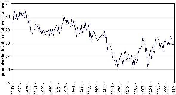
During the ensuing period, from the early ‘50’s to the early ‘80’s, the groundwater level sank continually and over large areas because of increased withdrawal. This was particularly noticeable in water production areas (waterworks facilities). The lowering was caused by the general rise in water consumption by private households, and by construction (rebuilding of the severely destroyed city, subway construction, and large-scale construction projects). The expansion of water production facilities in the West Berlin waterworks was completed by the beginning of the ‘70’s. The expansion of the Friedrichshagen Waterworks in East Berlin began in the mid-‘70’s, to supply water to the new residential areas in Hellersdorf, Marzahn and Hohenschönhausen.

A slight rise in groundwater levels has occurred in West Berlin since the end of the 70’s.

A number of reasons can be given for this rise: reduced withdrawal from private wells; reduced withdrawal at construction sites (a lower construction volume and enforcement of groundwater return); reduced withdrawal volumes by public waterworks; and, not least, effective anthropogenic groundwater recharging (cf. Map 02.11).

Following the political changes in 1989 (fall of the Berlin Wall), the level of water consumption in the eastern boroughs of Berlin was drastically reduced, and the production at the waterworks in those areas dropped an estimated 50 %. This resulted in a rise in the groundwater level throughout the city, east and west. Since then, it has kept relatively steady at this high level; a further increase has not been observed, however (cf. p. & Ch. Basic Data).

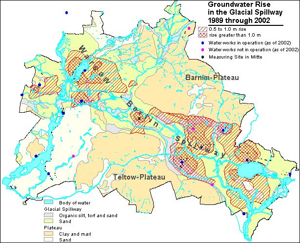
Those areas nearest to waterworks recorded level increases of as high as 3 m during the mid-‘90s. The Berlin Pleistocene Watercourse (or glacial spillway), which covers half the area of the city, has a very low depth to groundwater of only a few meters. Many of the cellars in some areas were not sealed appropriately, and therefore suffered damage through dampness due to a sudden increase in groundwater during this period. In two areas, the damage was so extensive that it was necessary to implement groundwater regulatory measures (Rudow, Kaulsdorf).

Permanent, wide and deep cones of depression have formed in water catchment areas around waterworks wells. The considerable differences observable among groundwater levels are directly related to variations in withdrawal requirements at the respective waterworks. Riemeister Lake and Nikolas Lake were dried out by the water withdrawals of the Beelitzhof Waterworks at the beginning of this century. The groundwater level of the Schlachten Lake fell by 2 m, and at Krumme Lanke by 1 m. Since 1913, water from the Havel has been withdrawn into the Grunewald lakes (inversion of natural flow) to balance this loss. The wetlands of Hundekehlefenn, Langes Luch and Riemeisterfenn, as well as the shore areas of the lakes have been saved by this measure.

The cones of depression around well galleries at the Havel Lake have effects deep into the Grunewald (forest). The groundwater level at Postfenn sank by 3.5 m between 1954 and 1974, and at Pechsee in the Grunewald by about 4.5 m between 1955 and 1975. Well gallery withdrawals at banks of the Havel have caused severe drying out of root soils of plants in the direct vicinity of the Havel.

About 90% of the wetlands around Müggel Lake in southeastern Berlin are threatened (Krumme Laake, Müggelheim, Teufelsseemoor, Neue Wiesen/Kuhgraben, Mostpfuhl, Thyrn, the lower course of Fredersdorfer Fliess).

Some wetland areas were flooded and given seepage of surface water to moderate negative effects caused by the lowering of groundwater levels. These were the West Berlin nature reserves Grosser Rohrpfuhl and Teufelsbruch in the Spandau Forest, and Bars Lake in Grunewald; in East Berlin, Krumme Laake in Grünau and Schildow in Pankow.

Large-scale lowering of groundwater levels has also occurred in the Spandau Forest, caused by the higher withdrawals by the Spandau Waterwork since the 70’s. A groundwater recharging plant, operated since 1983, percolates purified Havel water in an attempt to gradually raise groundwater levels. The groundwater level in the Spandau Forest had been raised by an average of 0.5 – 2.5 m by May 1987. Groundwater recharging in this area has been restricted again because water has appeared in cellars of near-by residential areas. The simultaneously increase in withdrawal amounts of the Spandau Waterwork lowered the groundwater level again after 1990. In the following period, the groundwater level rose once more, due to the further reduction of withdrawal amounts.

Fig. 3: Fluctuation of Groundwater Levels at Measuring Site 1516 in Spandau Forest

Fig. 3: Fluctuation of Groundwater Levels at Measuring Site 1516 in Spandau Forest

However, in May 2002, the groundwater surface was, all in all, at a relatively high level, as it had been during the previous seven years. The reason for this was declining water consumption, which can be seen from the reduced raw water intake by the Berlin Water Utility. Five small Berlin waterworks discontinued their production completely during the period between 1991 and 1997: Altglienicke, Friedrichsfelde, Köpenick, Riemeisterfenn and Buch. In addition, drinking water production at the two waterworks Johannisthal and Jungfernheide was discontinued temporarily in September 2001; at the latter, the same was true for artificial groundwater amplification. In the context of SenStadtUm groundwater management, groundwater is, however still withdrawn at both locations, so as not to endanger current local waste disposal and construction measures. The overall intake of the waterworks for drinking water purposes has dropped by over 40% in Berlin during the past 13 years: In 1989, 378 million m3 were withdrawn, as opposed to 220 million m3 in 2001. The drop in groundwater intake by the Utility in the eastern boroughs was even considerably higher – at 60% – during this period. The result was a city-wide groundwater level rise between 1989 and 2000, which most strongly affected the areas near the wells of the waterworks in the glacial spillway, with their deep cones of depression.

Fig. 4. shows the extent of the large-scale rise in ground-water levels since 1989. The map shows the rise in ground-water levels between 1989 and 2000.

Fig. 4: Groundwater Rise during the Period 1989 through 2000.

Fig. 4: Groundwater Rise during the Period 1989 through 2000.

h6. The rise shown reflects that in the observation pipes of the groundwater measurement sites, i.e., in the confined areas, the increase in groundwater pressure area, and not the actual groundwater surface. Due to the low density of data for the Barnim Plateau, the increase here could not be shown.