Climate Model Berlin - Planning Advices Urban Climate 2015

Map Description

Map 04.11.1 Main map

Settlement area

The thermal situation is classified as “unfavourable” or “less favourable” in around 60% of the settlement area. Especially for the evaluation class “unfavourable”, proactive measures for improving the situation as well as a more responsible handling of the resources is advised urgently. With a view on extreme events as well as the climate change, this can be extended to the areas of the class “less favourable”. In contrast, 40% of the settlement area is to be classified as favourable or as very favourable (see Figure 1). In case of construction measures, it is to be pointed out here that these do not lead to extensive negative impacts on the area itself as well as on adjacent areas for the day or night situation.

Percentage distribution of evaluation classes for the overall thermal situation in the settlement areas of Berlin.

Figure 1: Percentage distribution of evaluation classes for the overall thermal situation in the settlement areas (linking of day and night situation) of Berlin.

The thermal focus areas of the thermal stresses combined during day time lie in the districts of Friedrichshain-Kreuzberg and Mitte (see Figure 2 and Figure 3). Here, 80 % of the settlement areas fall in the classes “less favourable” or “unfavourable”, which results in a recommendation for improving the situation. Closed perimeter developments (area types 2 and 7) as well as the extensive retail trade (type 30) use more than 40 % of the area in both the districts. Accordingly high are construction volume and degree of sealing, and accordingly low is the volume of greenery. Both lead to high stresses in partial areas mainly in the night, but in some areas also during the day.

Comparatively good is the thermal situation in the districts Steglitz-Zehlendorf, Marzahn-Hellersdorf and Treptow-Köpenick, in which measures for improvement are necessary on less than 50 % of the area. The areas can be beneficial firstly because of their high share of greenery and their connection with the cold air origin areas in the city and in the surrounding regions (including Forst Grunewald in Steglitz-Zehlendorf, expanded forest areas between Müggelsee and Dahme in Treptow-Köpenick). Secondly, the historically more open development structure also favours a comparatively lower thermal stress level. Thus, “Single detached houses with garden” (type 23) are taking up the highest area portion in all districts. In Marzahn-Hellersdorf, this percentage is almost 50 %.

However, these values may not hide the fact that attention must be paid to a maintenance/development favouring the urban climate even in the bio-climatically favourable districts and in partial areas, measures are even advised for improving the thermal situation. A good example for this are the localities of Marzahn and Hellersdorf, whose “large settlement areas and high-rises” (type 23) show an unfavourable thermal total evaluation to almost 80 %, the main reason for which is the day situation or the situation on the public (road) space.

Figure 2: Spatial distribution of evaluation classes for the overall thermal situation in the settlement areas (linking of day and night situation ) of Berlin.

Balancing of the overall thermal situation in the settlement area of 12 districts of Berlin

Figure 3: Balancing of the overall thermal situation in the settlement area of 12 districts of Berlin

Public roads, paths, places

Around 55 % of the public roads, paths and places of Berlin can be assigned to both the highest evaluation classes (see Figure 4) For the road sections and places of class 4, it is recommended to implement the short-term measures for improving the thermal situation. These should unfold an effect for the day situation (mainly shadowing measures). If a settlement area designated as thermally stressed in the night situation adjoins directly, additional measures must be taken (mainly the ones, which reduce the heat storage). While doing so, a special focus should be laid on those sections, for which an unfavourable thermal situation as well as a high or very high traffic air stress was modelled.

In the medium-term, measures are also recommended on some areas, which were assigned to the class “less favourable”. During the heat periods, clearly higher stresses can be achieved here than the ones mapped in the modelling. In addition, the climate change will gradually increase the stress level of an average summer day on the public road space too.

On the remaining 45 % of the area of the spatial unit, the thermal situation can currently be identified as favourable or as very favourable. Measures for further improvement are not absolutely necessary, but should be taken into consideration, if possibly adjoining settlement areas show a stress and the measures cannot either be implemented there or not to an adequate extent.

Percentage distribution of the evaluation classes for overall thermal situation on public roads, paths and places in Berlin

Figure 4: Percentage distribution of the evaluation classes for overall thermal situation on public roads, paths and places in Berlin.

The spatial focus areas of the thermal load on the public roads, paths and places show a close relationship with the green volume or the portion of the area of road sections covered by road trees (both the parameters are present as calculated values from the captured vegetation structure (SenStadtUm 2014)). The base area coverage by the road trees is on an average only 8 % in the district of Marzahn-Hellersdorf. Even in case of green volume on the public road space, the district shows the lowest percentages; Steglitz-Zehlendorf, on the other hand, with the lowest percentages (24.5 %) of “less favourable” or “unfavourable” thermal conditions on public roads, paths and places, has in this spatial unit about 2.5 times the green volume as compared to Marzahn-Hellersdorf (see Figure 5 and Figure 6).

In most of the remaining districts, the area percentage of the cumulated values for the load situation lies between 55 % and 65 %. According to the current evaluation, the most pleasant bio-climate on the public road space is present in the districts of Steglitz-Zehlendorf, Charlottenburg-Wilmersdorf and Reinickendorf. The cumulative area percentages of the classes 3 and 4 here are between just 25 to below 40 %. The percentage of the area of road sections covered with trees shows that potential for improvement is still present in these areas. For both the last two mentioned districts, they lie between 14 % and 16 %.

Figure 5: Overall evaluation of the thermal situation on public roads, paths and places in Berlin.

Balancing of the overall thermal situation on public roads, paths and places of the 12 districts of Berlin

Figure 6: Balancing of the overall thermal situation on public roads, paths and places of the 12 districts of Berlin.

Air exchange

The extensive air-exchange system of Berlin consists primarily of three components:

  • Air conducting and ventilation pathways,
  • orographically-thermally induced, extensive cold air outflows,
  • thermally induced, line-like cold air pathways.

The air conducting and ventilation pathways, important for Berlin, follow the valleys of Havel, Dahme and Spree. They are significant mainly in case of allochthonous weather conditions, in which regional wind systems are formed because of more or less extensive air pressure differences. In Berlin, these weather conditions occur in the long-term mean (2001-2010), depending upon the station observed, between 61.9 % (Berlin-Grunewald) and 91.5 % (Berlin-Dahlem) (SenStadtUm 2015a). In doing so, western wind directions are prevalent. In the valleys, the introduced cold air is channelised, accelerated and transported in this way to the inner city having comparatively weaker winds (“jet effect”). To be able to make an optimum use of this phenomenon, the shore areas should be kept free and the development should be kept open in the transition areas to the water bodies.

Autochthonous weather conditions without (or with only weakly pronounced) higher-level wind systems occur rather rarely in Berlin (8.5 % – 38.1 % of the yearly hours). However, they are normally connected with stronger stresses for the health of the urban population, because the transportation of air pollutants is inhibited because of inversions and there is a characterisation of the urban heat island. For these weather situations, local, thermal and/or orographically induced cold air flows and floor wind systems take up the supply of the city with cold/fresh air.

The thermally-orographically induced cold air outflow is to be traced back to relief differences, which in the morning hours leads to an outflow of the cooling air parallel to the slope. The prerequisite for cold air outflow volume relevant for planning is an extensive slope inclination of > 1 %, which should also be assigned in the direction of a (thermally stressed) settlement area. Grunewald has the biggest, area-wise cold air outflow potential. The cold air can outflow here to almost 3,500 ha. The adjoining residential development benefits directly from this, in particular, in the northern and eastern part.

Purely thermally induced cold air pathways are, on the other hand, more frequent and also distributed more homogeneously over the city area. The reason for these is the small-scale succession of local high and low pressure area within Berlin during the night hours of autochthonous weather conditions and they see to it that air rising over the warm, densely built settlement areas is replaced at ground level by comparatively cooler air masses from their surroundings, especially larger green/open spaces. In particular for the inner city area, they represent the most important relief effects.

Demarcating their effective areas against one another and against those of the other components of the air-exchange system based on clearly defined areas is not possible without further model and technical measurement analyses owing to spatial overlaps. However, the core areas of the individual pathways can be demarcated spatially on the basis of modelling and approximately balanced and compared. The greenways are suitable to a large extent as core area of the thermally induced pathway type. They not only transport further the cold air generated in the outer area, but also enrich the air stream with additional volume of cold air. Relevant quantities of cold air can also be transported to the city over broad streets. The pathways with air-hygiene stress must be differentiated here from the unstressed pathways (VDI 2015).

The identification of the pathways and their corridors was done manually as an advisory estimate and is based on the characterisation of the autochthonous flow field of the FITNAH simulation carried out. In doing so, the demarcation of the pathway corridors is not for clearly defined areas and in the actual planning case (e.g. a construction project) requires at least one additional expert assessment.

For the city area of Berlin, a total of 21 pathways were identified (see Figure 7). Their core regions include a total area of around 1,250 ha, which is the same as 1.4% of the complete city area. Each pathway represents a central component of the air-exchange system of Berlin. For this reason, all structural obstacles are to be avoided, which could cause a cold air jam. The basic objective should be to maintain the portion of green and open areas. In case of a construction, the construction height should be kept as low as possible and the new structure should be aligned longitudinally to the pathway. Perimeter developments are to be avoided completely.

Figure 7: Core zones of cold air pathways ("pathway corridors") in Berlin

For all the three main components of Berlin’s air-exchange system, it is equally true that their individual structures (air conducting and ventilation pathways), potential areas (cold air outflows) or core zones (cold air pathways) can be derived from model results and other technical and geo-data. A demarcation of their specific effective areas with respect to area or component – which as a rule go much beyond the areas shown above – cannot be ensured with adequate surety without further in-depth studies owing to mutual spatial overlapping and influencing.

However, it is possible to map and balance the complete cold air effective area of Berlin’s exchange system (see Figure 8). A part of this analysis is also the cold air flowing out of the many smaller and bigger green areas as well as from the strongly green settlement areas. These local phenomena form the smallest piece of mosaic of Berlin’s air-exchange and offer a climate-ecological welfare impact mainly to the partial areas of settlement areas with cold air pathways or away from cold air outflow (this mainly concerns the districts of Mitte and Friedrichshain-Kreuzberg).

Figure 8: Summary effective area of the components of Berlin's air-exchange system in case of autochthonous weather conditions.

As shown by Figure 9, there are big differences among the Berlin’s districts with respect to the absolute and relative portion of the residents benefiting from cold air as well as the settlement area influenced. In all the mentioned categories, the districts of Reinickendorf, Pankow and Spandau have the three most favourable ranks. They benefit the most from the air exchange. The district of Reinickendorf is highlighted especially in the statistics: approximately 80 % of the residents or of the settlement area are connected to cold air flows. It can, therefore, be assumed in a justified way that the clear, below-average nightly thermal stress and mainly the very low portion of block (partial) areas of the class “unfavourable thermal situation” in the three areas is connected very closely with the good supply of cold air. This context can also be assumed in the opposite way for the districts of Tempelhof-Schöneberg and mainly Friedrichshain-Kreuzberg. In both the districts, only a few more than 20,000 residents (same as < 10 %) benefit from the cold air flows. On the whole in Berlin, based on the model results, around 1 million residents (same as approx. 30 % of the total population) benefit from the cold air transported to the city via the versatile air-exchange system or else from the cold air directly produced in it.

These values illustrate the central importance of the cold air management for Berlin. They also show an improvement potential, which can be exploited with the help of measures.

Figure 9: Balancing of cold air effect on the settlement area in Berlin according to districts

Green and open spaces

The highest worthiness for protection has been assigned to a little more than half of the green and open spaces of Berlin (Figure 10 and Figure 11). These areas include the climate-ecological compensation areas important for the current settlement structures. Their climate functions are very important. Structural interventions should be avoided or, if already prepared under the planning law (FNP construction areas), should be done under consideration of the fundamental climate functions. For optimising the ecosystem service, the objective should be a good flowing of the adjoining development, a networking with the neighbouring green and open spaces as well as an increase of micro-climate diversity. Along with all core-urban green/open spaces (incl. park at triangular junction, Tempelhof field, Great Zoo), some agriculturally useful areas to the north of Berlin are also part of the highest evaluation class.

A high worthiness of protection can be ascribed to around one-third of all green and open spaces of Berlin. The expanded forest areas of Berlin make up a major part of this at around 85%. Under the remaining portion of the areas, there is a dominance of parks, small gardens and fallow land with vegetation.

For the current settlement structure, these areas represent important climate-ecological compensation areas. Structural interventions should be done very moderately or, if already prepared under the planning law (FNP construction areas), under consideration of the fundamental climate functions. For optimising the ecosystem service, the objective should be a good flowing of the adjoining development, a networking with the neighbouring green and open spaces as well as an increase of micro-climate diversity.

Like this, around 95 % of all Berlin’s green and open spaces show a high to very high climate-ecological worthiness of protection. This illustrates the high relevance of most of the green and open spaces for a healthy climate of Berlin. Areas with an average worthiness of protection represent the supplementary space to the urban-climatic compensation system, but make up only a very low percentage of the complete area of the spatial unit. The adjacent development benefits from the provided climate function, but is normally not dependent on it. A low worthiness of protection was assigned to all remaining areas. For the current settlement structure, they do not provide any service relevant for climate-ecology. It is true for all areas with a low or average worthiness of protection that their evaluation in case of their construction or a construction in their immediate environment must be done again.

Percentage distribution of evaluation classes for climate-ecological worthiness of protection of open/green spaces in Berlin

Figure 10: Percentage distribution of evaluation classes for climate-ecological worthiness of protection of open/green spaces in Berlin

Figure 11: Spatial distribution of evaluation classes for climate-ecological worthiness of protection of open/green spaces in Berlin

Map 04.11.2 Supplementary planning instructions

Areas with special urban-climatic drawbacks

For all block (partial) areas of the settlement area or all road sections with a less favourable and mainly with an unfavourable thermal situation, it is recommended to implement the measures. Apart from this, there exists for some open and green spaces a potential for improving their climatic ecosystem services (e.g. in the context of micro-climate diversity). The areas with a special urban-climatic drawback are those sections of the areas, for which there is a priority need for action because of high stress level, which can be covered in the scope of an urban sanitation or an urban redevelopment.

To be able to give concrete instructions for the three spatial units (settlement area, green/open spaces, road space) of the main map, a differentiation has been done below in the following six area categories (see Table 1). Four of these refer to the settlement area. One differentiates here between the function of living, trade/industry, public utility/special uses and core areas. A category of priority action space was assigned each to public roads, paths and places as well as green and open spaces. The evaluation is based on purely climatic aspects as defined in a planning instruction. A linking with further vulnerability factors is done in a further step (see Section “Areas with a special vulnerability as compared to the urban climate”).

Table 1: Categories and methods for identifying the areas having special urban-climatic drawbacks

Table 1: Categories and methods for identifying the areas having special urban-climatic drawbacks

h6. * WOZ= Abbreviation for the categories of the structural uses, stands for “Living number”; detailed description see SenStadt 2010

Over all the area categories, 751 priority action spaces have been identified. The highest share in this is shown by the category “Road sections” at almost 60 %. To about one-third, the categories assigned to the settlement space are subsumed. The settlement type “Living” represents here the biggest group with 107 block (partial) areas. The remaining approx. 10 % falls on the category park | green area | town square | promenade (Figure 12).

Percentage distribution of the area categories with special urban-climatic drawbacks in Berlin

Figure 12: Percentage distribution of the area categories with special urban-climatic drawbacks in Berlin.

It can basically be determined that areas with priority need for action have been identified in all districts. The spatial focus lies in the districts Mitte (relevant for all area categories) and Charlottenburg-Wilmersdorf (the road space is mainly significant here). In both these districts, almost 40 % of the areas to be sanitised on priority are located. A subordinated focus point are the districts of Tempelhof-Schöneberg, Marzahn-Hellersdorf and Friedrichshain-Kreuzberg. In the districts Reinickendorf and Steglitz-Zehlendorf, on the other hand, there are only a few hot spots (Figure 13 and Figure 14).

Balancing of areas with special urban-climatic drawbacks for the 12 districts of Berlin

Figure 13: Balancing of areas with special urban-climatic drawbacks for the 12 districts of Berlin

Figure 14: Areas with special urban-climatic drawbacks in Berlin

Areas with a special vulnerability as compared to the urban climate

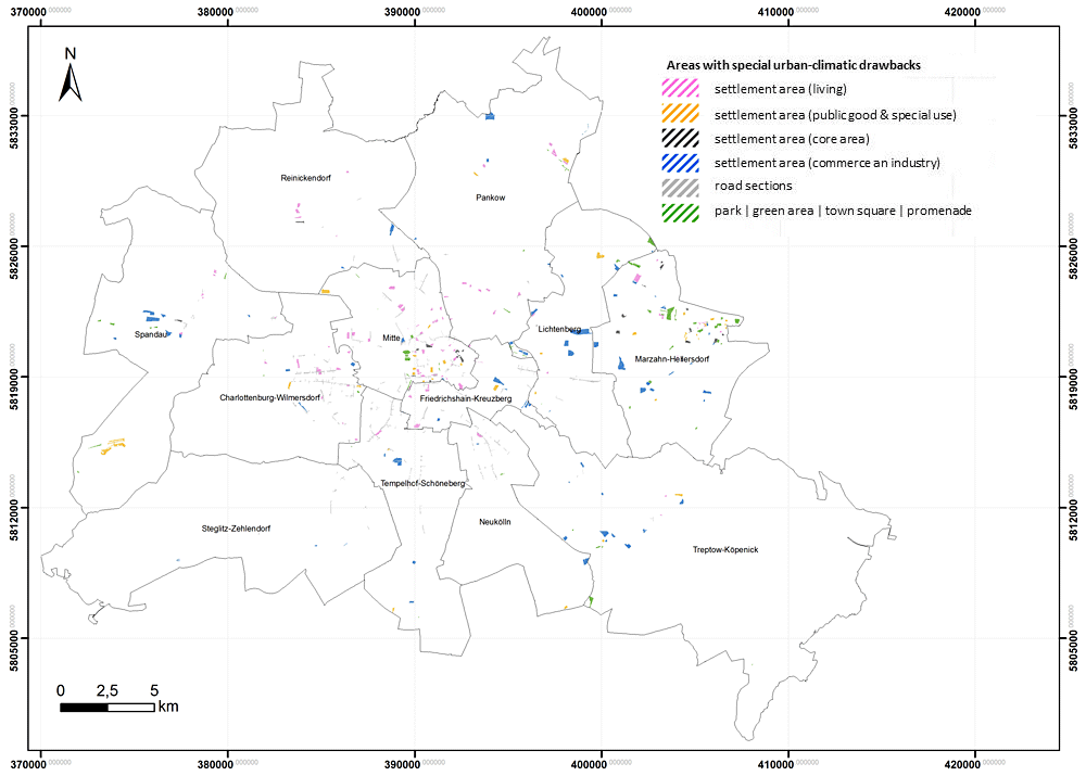
The identification of areas with a special urban-climatic drawback is based on a purely planning, climatic perspective. Their connection with further non-climatic criteria can disclose additional decision-making helps in the context of implementation of measures especially for the spatial unit “settlement area” as defined in a spatially differentiated vulnerability study.

To what extent the block areas of the settlement area are vulnerable to the city-climatic situation depends on primary criteria of time of stay/use as well as on further secondary factors. These include, above all, the demographic composition of the quarters observed. Apart from this, the availability of specific sensitive building/area uses as well as the degree of supply of residential areas with adequate green areas are the factors that influence the level of vulnerability.

h5. Special vulnerability based on demographic composition

Especially sensitive to the thermal (heat) stress are mainly the older people in the population (above 65 years [Ü65]) owing to the susceptibility to cardiovascular disorders increasing with age as well as small children below 6 years (U6), and mainly infants because of their lacking or not fully developed ability for thermal regulation (Jendritzky 2007). A relationship between an increased mortality and the occurrence of heat periods can be shown empirically for the areas of Berlin-Brandenburg and can also be mapped in a model (Scherber 2014, Scherer et al. 2013, Fenner et al. 2015).

In-depth information about the relationships between “Health and urban climate” is offered by the related excursus (Scherber 2016).

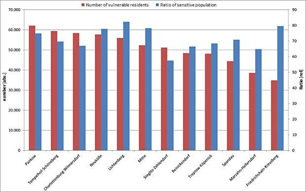
About 850,000 people live in Berlin, for whom a special thermal sensitivity can be assumed owing to their age (Statistics BBB 2014). The ratio of the sensitive older and the sensitive younger percentage of the population is approx. 3.4:1. It applies equally to all districts that the risk group of older people is much higher than that of small children and infants. This phenomenon is most strongly pronounced in the district Steglitz-Zehlendorf (5.3:1), where just about 90,000 of the thermally most sensitive residents of Berlin live. In Friedrichshain-Kreuzberg – the district with the lowest number of thermally sensitive residents (approx. 45,000) – there are only 1.6 Ü65 year old for one person in the age of U6.

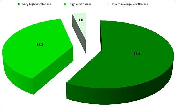
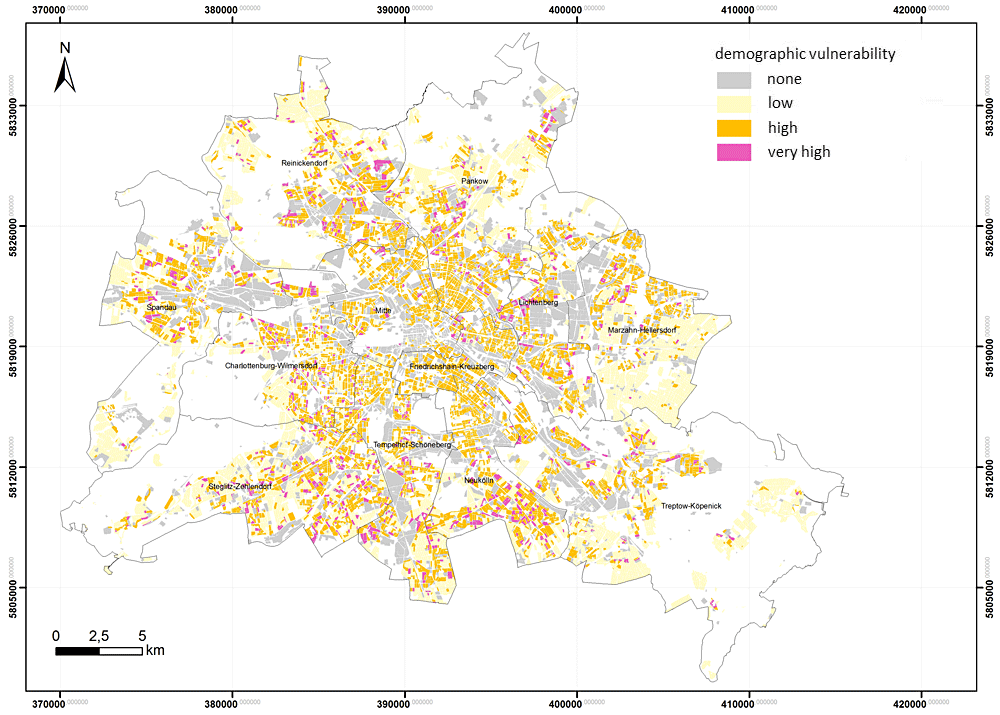
To what extent can an actual vulnerability also be derived from this sensitivity, depends essentially on the geographic distribution of the risk groups in the spatially differentiated stress field. In the result, there is a high or very high demographic vulnerability in approx. one third of all block areas, Approx. three quarters of all heat-sensitive Berliners live in these areas (around 650,000 residents). Vice versa, it also means that measures need to be implemented only in a comparatively small area, in order to give thermal relief to a high percentage of vulnerable population group.

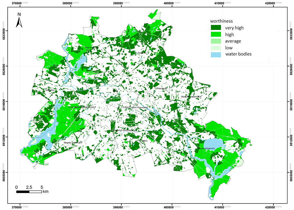
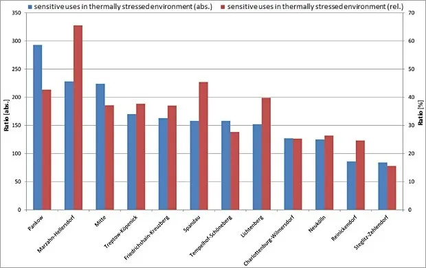
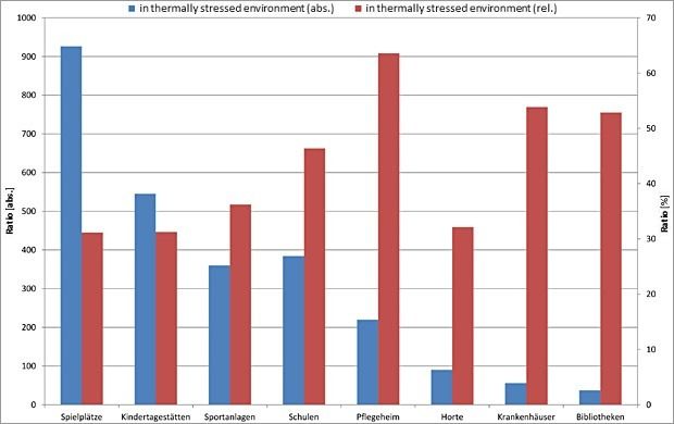
A spatially differentiated analysis at the level of Berlin’s districts shows that although there is a fundamental agreement in the distribution of population groups sensitive to climate with the space patterns of the actual demographic vulnerability, but there are still some essential differences (Figure 15 and Figure 16).

Thus, although the district Steglitz-Zehlendorf is the biggest group of thermally sensitive persons, the district has only rank 7 in case of demographic vulnerability. The reason for this is firstly that the stress level lies on the whole below the average. Secondly, the risk groups are currently living in thermally favourable areas. The reverse case applies to Pankow. Seen absolutely, there is the highest demographic vulnerability here, although the district has only the fourth largest sensitive population.

At the lower end of the scale, both the results match in contrast: Spandau, Marzahn-Hellersdorf and Friedrichshain-Kreuzberg show the lowest number of sensitive persons as well as the demographic vulnerability. However, it applies to Friedrichshain-Kreuzberg that the majority of the sensitive population also lives in areas with thermal stress (approx. 80 %). A higher percentage is also seen in the district of Lichtenberg (82 %). Even Mitte and Neukölln lie at the same level.

Figure 15: Demographic vulnerability as compared to thermal stress - Spatial analysis at the level of block areas in Berlin

Demographic vulnerability as compared to thermal stress - Balancing at the level of Berlin's districts

Figure 16: Demographic vulnerability as compared to thermal stress - Balancing at the level of Berlin's districts

h5. Special vulnerabilities based on building/areas uses sensitive to urban climate

Uses of areas/buildings sensitive from the perspective of urban climate are mainly the ones, which are preferably used by the risk groups. For the present analysis, a total of eight different usage types were differentiated: Hospitals, care homes, libraries, child day care centres, schools, after-school care centres, play areas and sports complexes. In the partial areas of the three higher-level space units of PHK 2015, there are currently a total of around 7,300 corresponding individual uses. The main share is constituted by about 64 % of play areas and child day-care centres.

On the whole, at least one climate-sensitive usage type is found in around 25 % of the settlement areas, approx, 12 % of all green and open spaces and 5 % of all partial areas of the space unit public roads, paths and places. In over 90 % of the cases, not more than two different usage types occur simultaneously for each partial area, but in the individual case up to six types occur as cluster.

The spatial distribution of the sensitive area/building uses within Berlin is relatively homogeneous and shows a high correlation with the total population with respect to the districts. The following applies: The more residents a district has, the more climate-sensitive uses also occur. Accordingly, the district of Pankow with almost 700 affected block areas is present at the upper end of the scale, while the district of Spandau is at the lower end with more than 350 block areas with at least one climate-sensitive use. The evaluation shows that there is a relevance for this topic too in all districts of Berlin.

To what extent an actual vulnerability of the individual areas results from this spatial distribution, depends essentially on the geographical position in the differentiated stress field. The absolutely viewed largest number of areas with vulnerable uses lies in the district of Pankow, which also shows the highest number of sensitive (also potentially vulnerable) uses of areas/buildings. Apart from this condition, the result does not disclose any relationship between the frequency of occurrence of vulnerable and sensitive uses / the population strength. The reason for this is the spatially divergent percentage share of sensitive uses in a thermally sensitive environment. With respect to complete Berlin, the corresponding value is 33 %. However, within the twelve districts of Berlin, this value fluctuates considerably between approx. 15 % in Steglitz-Zehlendorf and almost 66 % in Marzahn-Hellersdorf (Figure 17).

Absolute number and relative percentage of aggregated sensitive uses in thermally stressed environment in the 12 districts of Berlin

Figure 17: Absolute number and relative percentage of aggregated sensitive uses in thermally stressed environment in the 12 districts of Berlin.

In contrast, the sequence of the absolute number of vulnerable usage types matches exactly that of the ranking for the sensitive types. Play areas and child day care centres also occur here very frequently as the remaining usage types. They clearly make up more than 50 % of the total 2618 partial areas having vulnerable area/building uses. Similar to the district-wise evaluation, there are here also higher differences in the scope, in which the climate-sensitive uses also become actually vulnerable uses. Especially relevant is the high rate in case of care homes and hospitals, which are located in a thermally stressed environment to more than 50 % and for which a highlighted, prioritised need for action can be derived.

Absolute number and relative percentage of sensitive use types in thermally stressed environment in Berlin

Figure 18: Absolute number and relative percentage of sensitive use types in thermally stressed environment in Berlin.

h5. Special vulnerabilities based on a shortage of green areas

Apart from providing cold air, the open and green areas of Berlin also provide a second, central climate-ecological service: They are cool islands during the day, which can be visited actively by the (thermally) stressed residents of the city and provide for their relaxation. Unlike the production of cold air – which is dependent on larger consistent areas (> 1-2 ha) for the supply of relevant volume – a regular mosaic made of smaller green areas is especially suitable for a short-term relaxation. Only in this way it can be ensured in the sense of a social-ecological fairness that the residents of the city of all parts can fulfil their need for relaxation (Scherer 2007).

Viewed on a small-scale, the green and open spaces with a high percentage of shade are mainly important in such areas, in which a relevant thermal stress level occurs during the day together with a shortage of private green areas. A linking of both these parameters shows the partial block areas, on which there is a special city-climatic vulnerability because of a shortage of green areas. These areas require a special attention in the provision of thermal comfort islands (so-called “pocket parks”) in the private and public space.

On the whole, 807 partial block areas of the settlement area show a vulnerability against the urban climate because of a shortage of green area (matches about 5 % of all partial block areas or 4 % with reference to their area). The affected quarters have around 375,000 residents, of whom approx. 80,000 belong to a risk group. This implies that approximately each 10th Berliner or each 10th member of the risk group based on age structure is affected by the studied drawback.

The areas are distributed over the complete urban area of Berlin, but the spatial focus areas can be made out. The hot spots include the districts of Mitte and Pankow, which show the mostly affected partial block areas as well as the mostly affected residents. Together, they make up for a percentage of each approx. 30 % (130,000 residents, 250 blocks). During the day, both the districts are not among the most strongly stressed areas of Berlin, which indicates that the supply of green area is distributed unfavourably here with respect to thermal relaxation and/or there are too few relaxation areas on the whole. The reverse case applies to the district of Spandau. In comparison, it shows a lot of areas thermally stressed during the day, but only few vulnerable areas/residents owing to a shortage of green areas. The best situation exists in Steglitz-Zehlendorf, where a thermally relevant short supply can be ascertained for less than 10,000 residents (Figure 19 and Figure 20).

Figure 19: Spatial representation of areas with a special vulnerability as compared to the urban climate based on a shortage of green areas in Berlin

Balancing of the vulnerability as compared to the urban climate based on a shortage of green areas in the 12 districts of Berlin

Figure 20: Balancing of the vulnerability as compared to the urban climate based on a shortage of green areas in the 12 districts of Berlin.

Map 04.11.3 Measures

In the third main level of PHK 2015, 413 individual combinations of 30 different measures and planning instructions have been assigned to around 45,000 partial block areas and road sections. With 312 different measures combinations, a major part of this falls on the settlement areas, which also becomes clear in the area background of the individual measures. Moreover, 88 different measures combinations are assigned to green/open spaces, 12 to the spatial unit of public roads, paths and places as well as 1 to water bodies.

The assignment of measures depends upon the area type, the individual evaluations in the main map as well as in the supplementary planning instructions and some additional technical and geo-information. Based on the scale for the entire city, not all area specifications could be included comprehensively in the analysis so that the results summarised in Table 2 are to be understood as suggestions, which need to be checked and substantiated again when viewing an actual area or a specific measure (= search areas). In this context, there should also be an in-depth discussion on the supporting instruments and tools for implementing the measures.

Detailed statements for the 30 individual measures can be taken from the accompanying document of PHK (SenStadtUm 2015). More information can also be taken from the Urban Development Plan of Berlin for Climate and its substantiation (SenStadtUm 2011), the Climate Booklet for Urban Development (MVI 2012) as well as the Manual of Urban climate (MUNLV 2010).

Table 2: Recommendations for measures specific to spatial units as the third main level of the planning advice map for the urban climate of Berlin 2015

Table 2: Recommendations for measures specific to spatial units as the third main level of the planning advice map for the urban climate of Berlin 2015