Geothermal Potential - Specific Conductivity and Specific Extraction Capacity 2017

Map Description

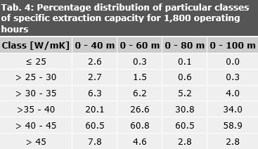
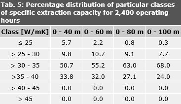
These maps show the specific conductivity and the specific extraction capacity for the state of Berlin. The specific extraction capacity calculated referred to the average single-family home, and are differentiated between space heating only, with an estimated 1,800 annual operating hours (Maps 2.18.5 – 2.18.8), and space heating plus hot water supply, with an estimated 2,400 annual operating hours (Maps 2.18.9 – 2.18.12), and is valid only under the given boundary conditions, shown in chapter Methodology. Maps have been prepared for four established possible depth levels: 0 – 40 m, 0 – 60 m, 0 – 80 m and 0 – 100 m.

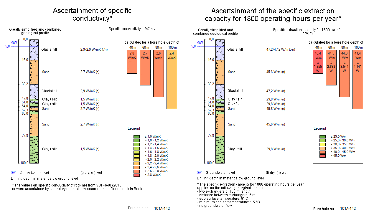
Based on these maps, an evaluation of the suitability of a site for use of geothermal energy is possible. In the simple case of a single-family home, extraction capacity can be directly determined; for other buildings, it can be calculated on the basis of specific conductivity (Maps 2.18.1 – 2.18.4).

This year’s update of the geothermal map was implemented programmatically as 2015 using mapping rules of the petrography and genesis attributes of the bore hole database. This results in differences in individual cases to the 2010, 2012 and 2015 map edition.

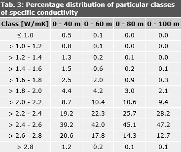
The percentage distribution of the particular classes of specific conductivity present on the territory of Berlin shows that more than 40 % of the surfaces at all depths can be assigned to the class > 2.4 – 2.6 W/mK (Tab. 3).

Tab. 3: Percentage distribution of particular classes of specific conductivity

Tab. 3: Percentage distribution of particular classes of specific conductivity

The specific extraction capacity of the systems which provide only heating without hot water preparation (1,800 h/a) is shown in Tab. 4 to be relatively high (> 40 – 45 W/m) for all depths in over 50 % of areas.

Tab. 4: Percentage distribution of particular classes of specific extraction capacity for 1,800 operating hours

Tab. 4: Percentage distribution of particular classes of specific extraction capacity for 1,800 operating hours

For systems with space heating and hot water supply (2,400 h/a), more than 50 % of the areas, at all depths, have a value of only >30 – 35 W/m (Tab. 4), while the > 35 – 40 W/m category accounts for only 20 to 30 % of the surfaces. A specific extraction capacity of greater than 40 W/m does not occur at all (Tab. 5).

Tab. 5: Percentage distribution of particular classes of specific extraction capacity for 2,400 operating hours

Tab. 5: Percentage distribution of particular classes of specific extraction capacity for 2,400 operating hours

Representation of single boreholes

In addition to the surface depiction of specific conductivities and specific extraction capacities, it is possible to click onto a particular borehole schematically, and thus access a borehole-specific graphic. Here, a concrete borehole is shown in a greatly simplified and combined geological profile, with the groundwater level. Moreover, data on the specific conductivity and the specific extraction capacity for 1,800 operating hours (space heating without hot water supply), or for 2,400 operating hours (space heating with hot water supply) – depending on the map from which the access has been started – can be accessed (Fig. 4).

Fig. 4: Schematic description of borehole, with information on specific conductivity and specific extraction capacity

Restricted areas

In the State of Berlin, supplying drinking water to the population has priority over the thermal use of the subsoil. The use of geothermal energy is hence generally prohibited in certified water protection areas. These areas are cross-hatched in black on the maps.

The use of geothermal energy is restricted in areas with highly saline groundwater above the Holstein layers (aquifer 2). This is to prevent further deterioration of the situation in the main aquifer. These areas are cross-hatched in blue on the maps.

In certain areas of Berlin, the use of geothermal energy is also restricted to ensure groundwater protection. This includes areas with highly saline groundwater located below the Holstein layers (aquifers 3 and 4), areas with artesian confined groundwater or higher levels of Rupelian clay. These areas are hatched on the maps. Additional information can be obtained from the responsible authority. The maps on geothermal potentials serve as a reference guide only. Any change in the marginal conditions, such as the arrangement of the exchangers, the number of operating hours (see above), etc. could lead to deviations in the extraction capacity. Therefore, the maps should not be used as an exact basis for planning.

This project has been funded in the context of the Environmental Relief Programme II by the European Fund for Regional Development in the state of Berlin (Project no. 11203 UEPII/3).

EU-EFRE-Logo

EU-EFRE-Logo