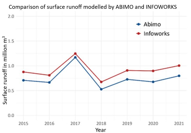
The validation covered the years 2015 to 2021, corresponding to the years in which the BWB used INFOWORKS to model sewered surface runoff in the Berlin I catchment in Friedrichshain-Kreuzberg.
Using ABIMO, surface runoff was calculated for all block segment areas (ISU5) within the same catchment, excluding areas classified as water bodies.
A comparison of the annual results shows that both models respond consistently to climatic variability and display closely aligned overall trends. However, ABIMO systematically estimates lower runoff volumes than INFOWORKS, averaging around 160,000 cubic metres per year less (Mean Absolute Percentage Error, MAPE: 23 %). The MAPE indicates the average percentage by which simulated values deviate from observed ones.
Validation using wastewater treatment plant data
For the second validation, inflow data provided by the BWB was analysed for the period from 1991 to 2020.
Measured inflows were adjusted by subtracting the estimated dry-weather flow, thereby isolating the rainfall-related runoff component.
Data from three wastewater treatment plants connected exclusively to the separate sewer system, where – in theory – only dry-weather flow should occur, was used to estimate the share of improperly connected surfaces. This share was then extrapolated to all treatment plants that also receive partial inflows from the separate sewer system and subtracted from the total runoff.
Losses from combined sewer overflows (CSOs) were also incorporated. These were calculated for each year, starting from an average overflow volume of approximately 5.5 million cubic metres in 1990, and scaled linearly across the study period using summer precipitation as an adjustment factor.
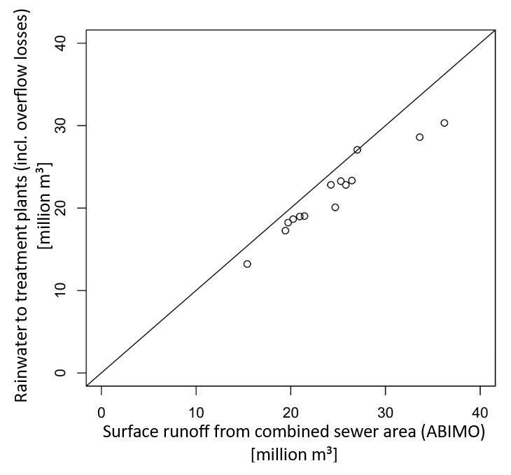
To determine the urban water balance, all block segment areas within the combined sewer system (see Environmental Atlas Map 02.09, 2022) were selected, and ABIMO was applied to all climatic years under investigation.
The comparison shows a strong correlation, although ABIMO systematically overestimates surface runoff relative to the observed wastewater treatment data (MAPE 11%).
Possible causes for this include:
- an overestimation of runoff from road surfaces, since water infiltrating into adjacent green areas may not be captured;
- a systematic underestimation of rainwater inflows from improperly connected surfaces in the separate sewer system; and
- an underestimation of combined sewer overflow volumes.