 German Sign language
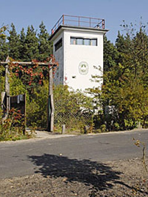
This route begins on Utestrasse; a GDR watchtower is nearby. It has been used by a youth organization, Deutsche Waldjugend, since 1990 as a base for its nature conservation work. Between Hohen Neuendorf and the Bergfelde neighborhood, the border ran parallel to Utestrasse from the northern end of Frohnau’s Invalidensiedlung right through the forest. As part of the GDR’s outer border, this section was closed as early as 1952 and developed into a multi-layered border installation with walls, fences, floodlights, and a border patrol road starting in 1961. The command post built in the 1980s was used to monitor the border and, at the same time, as a control center for other observation towers, which were spaced about 500 meters apart along the border strip. Each command post was occupied by three border guards and an officer, and also had a holding cell for any “border violators” who might be arrested. The 19-year-old East Berliner Joachim Mehr attempted to escape to West Berlin with his 23-year-old friend Hans-Jürgen K. near Bergfelde on 3 December 1964. Two border guards saw the two of them on the border strip and shot at them, killing Joachim Mehr. Hans-Jürgen K. was injured, but survived, while the border guards received medals and promotions. Info markers near the watchtower are dedicated to Joachim Mehr and two other victims of the Wall, Rolf-Dieter Kabelitz and Willi Born.
Berlin Wall Trail - From Hohen Neuendorf to Hermsdorf
 Former border crossings
-
Former waterway checkpoint Show on map
-
Former waterway checkpoint Show on map
 Museums and exhibitions
 Memorials
-
"Entenschnabel" Show on map
-
Cherry tree avenue Show on map
-
Memorial stone recalling Germany's division Show on map
-
Memorial "Mauerkletterer" Show on map
-
Klein Glienicke Show on map
-
Fichtewiese/Erlengrund Show on map
-
Memorial for desecrated graves Show on map
-
Memorial stone for German unification Show on map
-
Cherry tree avenue and memorial stone Show on map
 Artistic markers
-
Wall sculpture: "Border Crosser" Show on map
 Memorial sites for the victims of the Berlin Wall
 Commemorative sites
 Remains of the Wall
-
Checkpoint Qualitz Show on map
-
Remains of the Wall on Martin-Luther-Straße Show on map
-
Remains of the Wall on Schönwalder Allee Show on map
-
Remains of the Wall at Griebnitzsee Show on map
-
Section of the Wall at Potsdamer Platz Show on map
 Historical information
-
Berlin Wall History Mile Frank, Mispelhorn, Einsiedel und Proksch, Klemkestraße Show on map
-
Berlin Wall History Mile Jörg Hartmann u.a. Kiefholzstraße Denkmal Show on map
-
Information and orientation system Berlin Wall Brunnenstrasse Show on map
-
Information and orientation system Berlin Wall Spreebogenpark Show on map
-
Info board at Klein Glienicke Show on map
-
Info board: "Tunnel escape" Show on map
-
Info board at former watchtower Show on map
-
Info board at Steinstücken Show on map
-
Info board Rudower Strasse Show on map
-
Info board at border crossing Waltersdorfer Chaussee Show on map
-
Info board at Kölner Damm Show on map
 Places of interest
 Other key sites
Contact
Governing Mayor of Berlin – Senate Chancellery –
- Tel.: +49 30 9026-2435
- Fax: +49 30 9026-2285
- E-mail an die Landesredaktion Berlin.de