The structure types with predominantly residential use occur only in blocks or block segments which are designated in the Map “Actual Use of Built-up Areas” as residential areas, or as Mixed Areas I. The structure types with predominantly commercial, service, small business and industrial use exist only in blocks or block segments of the categories Core Area, Mixed Area II, Small Business and Industrial Area, Utilities Areas and, in individual cases, Mixed Area I. The structure types with other uses occur in blocks or block segments of the categories Public Facilities / Special Use, Traffic Areas, Construction Sites, and of all categories of Map 06.02 “Inventory of Green and Open Spaces.”
Update of Section Types Based on the Digital Map of Berlin 1:5,000 (ISU5)
All information about actual land use is managed and processed at the ISU (Informationssystem Stadt und Umwelt: Urban and Environmental Information System). This makes possible a graphic data processing of the factual data on basis of a uniform spatial reference system.
The spatial reference system (edition 2007) is provided by the digital map of Berlin in a scale 1:5,000 – the ISU5 of the ISU (Urban and Environmental Information System). This map differs from former editions based on ISU50 (generalized map for the scale 1:50,000) by its higher accuracy due to its scale of 1:5,000. It shows each individual statistical block, which is as a rule delimited by streets like in the ISU50. The numbering and limitation of the blocks are carried by the State Statistical Office (Statistisches Landesamt).
The smallest reference segment is formed by the block segments, which were delimited for different land use within a statistical block.
The uniform reference system makes possible a clear spatial identification of all factual data. Over a common key, which contains, among other things, borough, block and block segment numbers, these data are assigned to the spatial reference system.
Streets do not have any area in the ISU spatial reference system. The course of the street is described by the boundaries of the individual statistical blocks.
The data on actual land use are stored in the use data base. This data base contains, in addition to a statement of the actual land use of a block and/or a block segment, further information about the area size, the section type, the sealing degree, the distribution of differently permeable surface covers.
Update of the Digital Map of Berlin 1:5,000 (ISU5)
The update of the edition 2007 was implemented by an external contractor by means of aerial photography and personal area inspections. Changes of land use between 2001 and 2005 were mapped. Adaptations of geometries and actual block numbers from the department of statistics (Amt für Statistik Berlin-Brandenburg) were made.
According to the methodology of portraying uses and types of areas of the Environmental Atlas Berlin blocks were separated into block-segments. This happened when the current use of a block area could be separated into a residential or open-space type of use. These block-segments were documented by a unique code in the GIS database and the statistical data base.
All together 806 new block/block-segments were created.
Further all railroad properties were updated in 2007, altogether 696 railroad properties and rails were marked off.
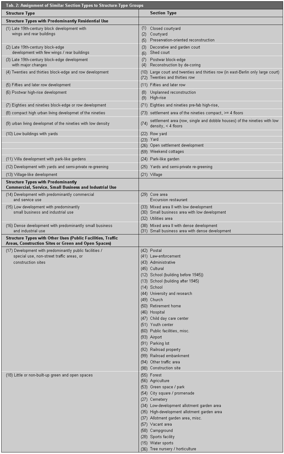
Fundamentally, a single block or block segment received only one section-type designation. If different section types existed within a block or block segment, such as “yard” and “fifties and later row,” the dominant section type was chosen. The following text describes the essential attributes of the single structure types.
Structure Types with Predominantly Residential Use
Late 19th-century block development with wings and rear buildings
This construction structure is marked by closed or almost-closed, predominantly five to six-story block-edge development. According to this section type, the individual properties are built up along more than one, or even all, sides, with a front building, wings and a rear building. The development originated in the years 1870-1918. As part of the preservation-oriented reconstruction at the end of the seventies and in the eighties, former vacant lots were filled by new buildings, and old buildings were renovated. Demolition was carried out only in isolated cases. In East Berlin, the areas rehabilitated at the beginning of the seventies are included, in which relatively large-scale demolition of rear buildings and consolidation of courtyards was carried out.
The open-space structure is marked by crooked block interiors. These consist of entirely or largely enclosed, narrow courtyards, sometimes arranged in a row, and connected by court passages. The courtyards are mostly paved with concrete, asphalt or stone. Sometimes the building edges are planted with decorative flower beds, or single tree is found in the courtyard.
Late 19th-century block-edge development with few wings/rear buildings
In this construction structure, four-story, almost closed block-edge development predominates. The individual properties are built-up with a front building and wings or a rear building. The development emerged mainly between 1892 and 1918; in some cases, older buildings are integrated. The share of the “shed-court” type, which emerged before 1892 and consists mostly of two to three-story houses, some with a village-like structure, increased over time. The block edge is closed only partially. The individual properties are built-up in the rear with one- or two-story sheds.
The open-space structure is distinguished by front yards. The block interior is indented (with wings) or longitudinal (with rear buildings), and not subdivided by fences at the property boundaries. The block interior of the type “shed court” is further subdivided by closed courtyards, which are formed by walls and sheds. Cobblestone pavements prevail as the surface covering. At the edges of the court area, spontaneous vegetation prevails. Industrial use is more frequent than garden and orchard use. With the type “decorative and garden court,” on the other hand, the garden-like formation with fruit trees and flower beds dominates.
Late 19th-century block-edge development with major changes
This construction structure is marked by five to six-story, largely closed block-edge development, interspersed in some cases by entrances, parking lots and scattered vacant lots. This structure developed out of previous late 19th-century courtyard development. The high share of post-World-War-II new buildings at the block edges results from the closing of vacant lots (postwar block-edge) or is a consequence of rehabilitation measures, in which buildings with poor structural soundness were demolished and were replaced by new buildings. The courtyard structure of the “postwar block-edge” type was changed by demolition of individual rear buildings and, for the “reconstruction by de-coring” type, by demolition of nearly all rear buildings.
The open-space structure has a relatively open, coherent block interior, compared with the former courtyard development. In the section type “postwar block-edge,” the block interior is subdivided by fences along the non-built-up property edges. In addition to the old late 19th-century court formations, one finds, in the new or restored courts, paved parking lot areas, in some cases with landscaped edges. In the type “reconstruction by de-coring,” the block interior is often designed as a common space for residents, with playgrounds, paths, and easy-to-care-for green spaces.
Twenties and thirties block-edge and row development
The construction structure is mostly three to four-story, closed or almost-closed block-edge or open development with parallel longitudinal rows of houses. For exposure, the rows extend mainly in east-to-west direction. In some cases, the severity of the row development is loosened up by cross buildings at the block ends, or by a mixture of row and edge development. This section type emerged mainly in the twenties and early thirties.
The open-space structure is marked by large, coherent block quadrangles or by longitudinal, non-closed intervals between the rows. Typical is the distinctive landscaping, with green space areas and scattered trees, as well as hedges along the entrance areas and around the playgrounds and trash-can areas; in some cases, the courts are used as tenant gardens. A low proportion of paved area is typical, since the block interiors are not to be used as parking lots.
Fifties and later row development
In this construction structure, rows of four-story houses prevail. They were laid out initially mainly in an east-to-west direction; later, they were also built staggered in displaced order, or along curved blocks.
Relatively large, longitudinal, non-closed open spaces between the rows of houses characterize the open-space structure. About a third of the open space is used as parking lots and for access driveways. Ornamental green spaces with scattered trees and bushes predominate. Playgrounds, trash-can areas and parking lots are mostly lined by bushes and trees. In the developments built during the seventies, the share of green space was reduced in favor of raised flower beds along broad access driveways.
Postwar high-rise development
Large, high rows and single houses with varying floor-spaces mark the construction structure. The type “high-rise” means at least eight floors in West Berlin, and at least six floors in East Berlin. For the West Berlin types “unplanned reconstruction” and “high-rise,” the order of the buildings within the block appears open, without recognizable rules. The prefab concrete buildings laid out in East Berlin as large-scale developments were built partly in semi-open block-edge style, and partly mixed with row development. The section type “unplanned reconstruction “ emerged after 1945 on blocks of former late 19th-century block-edge development, while the type “high-rise” emerged in West Berlin predominantly during the sixties and seventies, and in East Berlin during the seventies and the beginning of the eighties, mostly in the form of large-scale developments.
The open-space structure of the large-scale developments in East Berlin in semi-open block-edge development of the type “high-rise,” displays a relatively large block interior, which is partly broken up by building rows in the block interior. For the type “unplanned reconstruction,” undeveloped areas are used relatively sparingly, mostly as parking lots; the remaining open areas are green edge-strips. The share of the non-built-up areas is relatively large for the type “high-rise.” Half of the area is paved by large access driveways and parking lots, the other half is landscaped as ornamental green space, geometrically designed with trees and shrubs.
Eighties and nineties block-edge or row development
Three to five-story, semi-open or closed block-edge development, or a mixture of rows and block-edge development in pre-fab concrete-type construction characterize the construction structure. These large-scale developments were built in East Berlin during the eighties and nineties.
The open-space structure consists of relatively large open spaces. The block interior is partly subdivided by building rows. Approx. a third of the non-built-up area is used as parking lots or for access driveways; otherwise, ornamental green spaces with landscaped trees and bushes predominate.
Compact, high urban living development of the nineties and urban living development with low density of the nineties
The big settlements created since the beginning of the nineties differ considerable from the typical big settlements with prefabricated houses erected almost exclusively in East Berlin. They include a wide span of city structures, (e.g. block edge development row development, row-house development, villa development). To enable a differentiation of the big settlements with prefabricated houses of the younger reconstruction areas, two new section types were defined on the basis of the height of the buildings. These areas are usually bigger housing projects in the framework of city development (e.g. water city Spandau, Rummelsburger bay or Karow north).
The section type compact, high development of the nineties is characterized by houses with more than 4 floors with closed yards or half closed yards, partially also with row development. These developments are erected with common infrastructure installations (shopping center, school, kindergartens, energy supply, waste disposal facilities etc) and sometimes in a ecological way of constructing. The structure of open spaces consists of big, publicly usable lawns with rainwater seepage facilities, partially with roof and facade greening and small, privately usable terrace gardens. The average seal degree for 250 areas is approximately 54 %, (spans 20 % until 90 %), the average development degree 33 %, (spans 10 % until 75 %).
The section type urban living development with low density of the nineties consists of rows -, double and one-family houses with fewer than 4 floors, erected mainly at the outskirts. Carports and private gardens etc. are usually on the small private properties, in the case of block structures in the interior areas. The share of publicly usable open spaces is rather low. The average seal degree for approximate 80 appraised areas lies at 50 % (spans 25 % until 80 %), the average development degree is 30 % (spans 10 % until 60 %). The inhabitant density is clearly lesser than in the compact, high development of the nineties.
Low buildings with yards
Mostly one to two-story developments with row houses and closely-built semi-detached houses, single family houses and smaller apartment houses or weekend cottages characterize this construction structure. Until 1945, the buildings were built around the block edge along a uniform building line. After the war, the row houses were frequently staggered along access streets and walkways in the block interior, and the single family houses were erected at irregular distances from the street and, ever more frequently, in the rear of the property, as second houses (hammer-shaped lot). With this type of “open settlement development”, single-family houses, workshops, garages and summer homes appeared at various times, without any planning.
The open-space structure of settlements erected before the war of the types “row-yards” and “ yards “ is marked by uniformly broad front yards and a large block interior, which is broken up only by property enclosures. With all other settlements of this type, the block interior is interspersed with houses. The non-built-up areas are as a rule used as fruit, vegetable, or ornamental gardens.
Villa development with park-like gardens
Predominantly two-story, open block-edge developments with villas behind a uniform building line mark the construction structure. For the buildings, which emerged between 1890 and 1930, a large building volume is typical.
The open-space structure is marked by uniformly broad front yards and the large block interior, and property enclosures with dense hedges or old masonry. The large yard properties have old tree populations on green spaces, in some cases also vegetable gardens and flower beds.
Development with yards and semi-private re-greening
This construction structure is marked by open, multi-story block development with rental and studio apartment houses between single family houses and villas. This type has emerged since 1950 by demolition and condensation of the development of the types “yards “ and “park-like garden.”
A block interior interspersed by larger buildings characterizes the open-space structure. The non-built-up areas are used as yards, or are landscaped uniformly with creepers and ornamental bushes, with pathways reinforced by concrete pavement, and parking lots as well as by gravel strips surrounding the houses.
Village-like development
This construction structure can be described as mostly one or two-story – or, near the city, multistory – development. Between the houses of the former village cores, new buildings of different size have emerged.
The open-space structure is characterized by the preservation of such village elements as the lay-out of the streets, the village green, the village pond, the manor park, or the church grave-yard. The open spaces are used as vegetable gardens or orchards, garden cafés, warehouses for commercial enterprises, workshops etc..
Structure Types with Predominantly Commercial, Service, Small Business and Industrial Use
Development with predominantly commercial and service use
Typically; this type has a high, 75-100% proportion of commercial and service enterprise. The “core area” type is as a rule built very compactly, and occurs mainly in the center of Berlin. The non-built-up parts of the core areas are used intensively, mostly as supply areas and as car parking spaces for staff members, customers and visitors; accordingly, they are often reinforced with asphalt, concrete or stone pavement systems. The section type “excursion restaurants” covers larger excursion restaurants in rest areas. For the non-built-up areas of this section type, large terraces, yards and access driveways, as well as many parking spaces for cars are typical.
Low development with predominantly small business and industrial use
These areas are marked by industrial development with predominantly one or two-story halls and building complexes and generous marginal areas. Under the category “utilities areas,” this also includes the buildings and property areas of the electricity, gas, water and sewage works, the sanitation department and others. Residential use is largely absent. The properties are at most 50% built-up. The large, non-built-up areas serve for storage, as shipment areas for goods, or as car and truck parking spaces. Large, unused, mostly vegetation-covered areas also occur.
Dense development with predominantly small business and industrial use
The main feature of these areas is industrial use. The property areas are built-up to more than 50% with multi-story, predominantly industrial and industrially-used buildings. One finds commercial complexes with factory lofts, factory lofts in rear buildings and wings, or lots with industrial buildings. The non-built-up area is intensively used for delivery traffic and is accordingly paved to a very great degree. These heavily built-up industrial areas frequently emerged during the late 19th-century.
Structure Types with Other Uses (Public Facilities, Traffic Areas, Construction Sites or Green and Open Spaces)
According to these structure types, all areas designated as “ public facilities/ special use,” “traffic areas,” or “construction sites” block and/or block segments in the Map 06.01 “Actual Use of Built-up Areas” are grouped together into one structure-type category, and all green and open-space inventory use types shown in Map 06.02 “Inventory of Green and Open Spaces” are grouped together to form a further structure type (cf. Tab. 2).
The construction carried out in West Berlin during the eighties and nineties was fitted into the existing structure types. For instance, the IBA buildings on Lindenstrasse in the borough of Kreuzberg are classed as section type “reconstruction by de-coring.” The development on Osdorfer Strasse at Lichterfelder Ring was assigned to the section type “fifties and later row.”
Some section types appear only in East or only in West Berlin. The section type “closed courtyard” is included under the section-type “courtyard” in East Berlin. The section type “reconstruction by de-coring” exists only in West Berlin, since in East Berlin, fewer court buildings were torn down. Also, the section type “unplanned reconstruction” developed only in West Berlin. On the other hand, the type “Eighties and nineties block-edge or row development” emerged only in East Berlin. The section type “open development” was reintroduced. In West Berlin, it occurs only rarely, and was included mostly under the type “yard”.